

You are using an out of date browser. It may not display this or other websites correctly.
You should upgrade or use an alternative browser.
You should upgrade or use an alternative browser.
Enhanced Warning Zone
- Thread starter Lees23
- Start date
Don't rely on the FLY app to make decisions about where to fly. It's often incomplete and doesn't provide the official information on airspace. Download the FAA's free B4YOUFLY app or use the online version.Can I fly in an Enhanced Warning Zone?
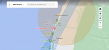
That area is in controlled airspace around the airport. You'll need LAANC approval to fly there. Most of the coast has a 0' ceiling. You won't be able to get automated approval there; but you can request it separately. South of Kaanapali Landing there's some 200' airspace so you could fly there with automated approval. The Aloft app can be used to get LAANC clearance there.
Here's the screen from B4YOUFLY.

66427cobra
Well-Known Member
I don't believe you can get approval, as a recreational pilot, in areas where the max altitude is 0' AGL. It is possible if you are Part 107 certified and you complete an online request. I haven't done one in a while but I also had to specify the specific area, the purpose, specific date and time, and requested altitude AGL. It wasn't instant approval either like LAANC.Don't rely on the FLY app to make decisions about where to fly. It's often incomplete and doesn't provide the official information on airspace. Download the FAA's free B4YOUFLY app or use the online version.
That area is in controlled airspace around the airport. You'll need LAANC approval to fly there. Most of the coast has a 0' ceiling. You won't be able to get automated approval there; but you can request it separately. South of Kaanapali Landing there's some 200' airspace so you could fly there with automated approval. The Aloft app can be used to get LAANC clearance there.
Here's the screen from B4YOUFLY.
View attachment 145298
Things may have changed as there have been a lot of changes to regs. But I doubt this one has changed as it involves close proximity to an airport.
Be careful out there...
I don't believe you can get approval, as a recreational pilot, in areas where the max altitude is 0' AGL. It is possible if you are Part 107 certified and you complete an online request. I haven't done one in a while but I also had to specify the specific area, the purpose, specific date and time, and requested altitude AGL. It wasn't instant approval either like LAANC.
Things may have changed as there have been a lot of changes to regs. But I doubt this one has changed as it involves close proximity to an airport.
Be careful out there...
Yes. It's a different process from the automated LAANC approval and a 107 ticket is required.
Even if you did get clearance to fly in a 0' ceiling area, it wouldn't be a very interesting flight. (humor)
Thanks for the help fellas. I always error on the side of cation and of there is any question, I don’t fly..
This may be a really stupid question, and apologize if my ignorance upsets anyone.. but if I had a Mini, could I fly here? I am watching a guy fly a mini now, is one of the reasons I ask. I know < 250G drones don’t have to be registered, but doesn’t that also mean fly (some) restrictions don’t apply?
This may be a really stupid question, and apologize if my ignorance upsets anyone.. but if I had a Mini, could I fly here? I am watching a guy fly a mini now, is one of the reasons I ask. I know < 250G drones don’t have to be registered, but doesn’t that also mean fly (some) restrictions don’t apply?
The area you are showing is in Class E2 (surface E) airspace and in a 0 altitude area for LAANC. If you are 107 rated you could submit a request through the FAADroneZone, but if you are Recreational then you cannot get authorization to fly there. Using a sub 250g drone like the Mini does not permit flights, all it means is you do not have to register unless you use it for 107 purposes. The following is a screen shot using Aloft which shows the area around the airport that is 0 altitude (surface).

Last edited:
Thanks for the help fellas. I always error on the side of cation and of there is any question, I don’t fly..
This may be a really stupid question, and apologize if my ignorance upsets anyone.. but if I had a Mini, could I fly here? I am watching a guy fly a mini now, is one of the reasons I ask. I know < 250G drones don’t have to be registered, but doesn’t that also mean fly (some) restrictions don’t apply?
If he doesn't have FAA Authorization it's an illegal flight regardless of the brand, model, weight of the aircraft. A LOT of people get confused about that and it's very much NOT a stupid question at all. Well asked
")
Saladshooter
Well-Known Member
The question is why is the DJI GEO Zone map so different than the B4UFLY map.?If he doesn't have FAA Authorization it's an illegal flight regardless of the brand, model, weight of the aircraft. A LOT of people get confused about that and it's very much NOT a stupid question at all. Well asked
B4UFLY's map closely follows the FAA charts on airspace restrictions which creates a circular pattern around most airports. DJI's GeoZone map seems to just restrict normal take off and landing routes other than immediately around the airport.
If DJI's goal is flight safety, I can't understand why this is so.


B4YOUFLY is FAA's product, so it should very closely mirror the FAA regulations. It's the authoritative app.The question is why is the DJI GEO Zone map so different than the B4UFLY map.?
B4UFLY's map closely follows the FAA charts on airspace restrictions which creates a circular pattern around most airports. DJI's GeoZone map seems to just restrict normal take off and landing routes other than immediately around the airport.
If DJI's goal is flight safety, I can't understand why this is so.
View attachment 145322View attachment 145323
Considering that DJI tries to address most of the occupied world, it's not a bad effort at keeping DJI drone users from bumbling into the most sensitive airspace. It seems to focus on airports and doesn't show things like U.S. National Parks. You can get into a bind if you rely solely on the DJI GeoZone Map.
The question is why is the DJI GEO Zone map so different than the B4UFLY map.?
B4UFLY's map closely follows the FAA charts on airspace restrictions which creates a circular pattern around most airports. DJI's GeoZone map seems to just restrict normal take off and landing routes other than immediately around the airport.
If DJI's goal is flight safety, I can't understand why this is so.
View attachment 145322View attachment 145323
DJI GEO Zone map - Map created by Drone Manufacturer trying to make a best effort at keeping unknowing DJI operators from flying where they shouldn't be. They make DRONES.
B4UFLY map - Map created (under contract) for the FAA to be an official source of FAA Regulated Airspace.
Consider the course and remember that the DJI Map, regardless how accurate it is or not, is not legal in ANY WAY!!
My Air 2S hasn’t left it’s case. Above you said much of the coast is 0’ ceiling but when I go on B4UFLY and am outside of the restricted airspace, I don’t see anything saying 0’ ceiling. Do you just mean inside the airspace? It appears I should be able to fly from Lahaina, correct?Don't rely on the FLY app to make decisions about where to fly. It's often incomplete and doesn't provide the official information on airspace. Download the FAA's free B4YOUFLY app or use the online version.
That area is in controlled airspace around the airport. You'll need LAANC approval to fly there. Most of the coast has a 0' ceiling. You won't be able to get automated approval there; but you can request it separately. South of Kaanapali Landing there's some 200' airspace so you could fly there with automated approval. The Aloft app can be used to get LAANC clearance there.
Here's the screen from B4YOUFLY.
View attachment 145298
Attachments
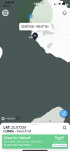
RIght, I was talking about the specific location of the marker on the chart and the western portion of the controlled airspace around the airport. To the south, still inside the controlled airspace, there are some 100 - 400' blocks where you could fly with LAANC approval. Once you get beyond the controlled airspace things look wide open for a long way.
Have fun and post some photos and video.
Have fun and post some photos and video.
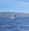
I appreciate all your help. We are headed home soon, so there won’t be any shots from the A2S. We did get some great whale footage. I don’t see a way to post videos. We had a whale direly under us so I stuck my phone in the water.RIght, I was talking about the specific location of the marker on the chart and the western portion of the controlled airspace around the airport. To the south, still inside the controlled airspace, there are some 100 - 400' blocks where you could fly with LAANC approval. Once you get beyond the controlled airspace things look wide open for a long way.
Have fun and post some photos and video.
Attachments
Just click this link to open B4UFLY to a Lahaina takeoff point... B4UFLY is free, and very easy to use.
 b4ufly.aloft.ai
Air Aware - The Leading Airspace & Situational Awareness Tool for Drone Operators
Can I fly my drone here? Use Air Aware on the web or mobile devices to check the airspace for federal & local UAS rules & regulations before taking flight.
You're very welcome. Wow, that's quite a nice shot of that whale. For videos, it seems like posting to Youtube and then providing a link here is the common route.I appreciate all your help. We are headed home soon, so there won’t be any shots from the A2S. We did get some great whale footage. I don’t see a way to post videos. We had a whale direly under us so I stuck my phone in the water.
I hope your phone survived. Mine did fine after being under five feet of water beneath the kayak for 45 minutes a couple of winters ago when I was helping a couple of biologists check on a cold-shocked manatee.
Yes, registration is required to use LAANC.
UAS Data Exchange (LAANC)
 www.faa.gov
UAS Data Exchange (LAANC)
To qualify under Part 107, you must register your drone and hold a Remote Pilot Certificate.
To qualify as a Recreational Flyer, you must register your drone and follow these steps.
(Note that the language for recreational flyers is a bit misleading. For recreational registration, the pilot is registered, not the drone. All the drones operated by the registered pilot display the same registration number.)
Similar threads
- Replies
- 3
- Views
- 759
- Replies
- 3
- Views
- 1K
- Replies
- 0
- Views
- 302


DJI Drone Deals
1. Mini 2
2. Mini 3 Pro
3. Mini 4 Pro
4. Air 2s
5. Air 3
6. Avata 2
7. Mavic 3 Pro
8. Mavic 3 Classic
2. Mini 3 Pro
3. Mini 4 Pro
4. Air 2s
5. Air 3
6. Avata 2
7. Mavic 3 Pro
8. Mavic 3 Classic
Forum statistics
