DJI Mavic, Air and Mini Drones
Friendly, Helpful & Knowledgeable Community
Join Us Now

Air 2 Google Map Photos

Hummingbird.UAV

Well-Known Member
Premium Pilot
Joined
Jul 3, 2019
Messages
353
Reactions
536
Location
Fort Saskatchewan Alberta
Site
www.youtube.com
I have shared 950 of my travel photos on Google Maps. I am fortunate to have traveled around the world a number of times. The last two times with at least two DJI drones. Google Maps loves 360° panoramas which drones do a wonderful and easy way of creating.

Below is an image that shows locations of my posts.
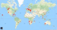
Google Map Pins.JPG
Recently I have shot many indoor 360°s with my Mavic Air 2. I was astonished that a photo uploaded Aug 8 received half a million views by Sep 20.
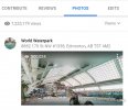
500000 Views C.jpg
Frankly I cannot explain why as it has outperformed all of my other uploads.
Below is the link to it.
Water Park 360° Pano
 
Its flawless , amazing on the Wide Screens, hard to believe it was done by the drone. Im sure every child in all of the Hemispheres clicked on that link .

Phantomrain.org
Gear to fly in the Rain and Land on the Water.
 
Very cool! Regarding the number of views, do you know how Google counts those? Is it counting, for example, every time someone accesses that address, regardless of whether or not they actually view the image?
 
Very cool! Regarding the number of views, do you know how Google counts those? Is it counting, for example, every time someone accesses that address, regardless of whether or not they actually view the image?
I don't know how GM does their counting however this high count is not from just clicking the address. I have 3 other photos of the same place loaded a month earlier and they are only in the tens of thousands views.
What I did discover is that GM will take an image and assign it to a much wider subject. This waterpark is in the city of Edmonton. Right now if you search for "Edmonton" in GM on a phone, it loads one image in the lower left. Right now that image is my waterpark image. Hopefully they keep it for another two months and I could achieve a million views.
 
Google Maps loves 360° panoramas which drones do a wonderful and easy way of creating.
I've tried for hours to figure out how to upload my 360 panos into Google Maps with the location, but no joy. Can you make a video to show everyone how you are doing that? I've changed the photo metadata to show camera brand Ricoh, using model Theta S, which works for other pano sites, but it doesn't work for GM.
 
I've tried for hours to figure out how to upload my 360 panos into Google Maps with the location, but no joy. Can you make a video to show everyone how you are doing that? I've changed the photo metadata to show camera brand Ricoh, using model Theta S, which works for other pano sites, but it doesn't work for GM.
Two questions, what are you using to shot the panorama? Have you loaded them to Google photos? In Google photos if the meta data is not correct but the image is a 360 google will figure it out in a day and then display it as a 360. (If the meta data is correct it will instantly display as a 360)
 
I'm using my M2Z, and I let the craft stitch the images together. Unfortunately the M2Z camera is not recognized as a legit 360 pano camera by most 360 viewers. As a result, I have been changing the M2Z photo metadata, stating the camera type is "Ricoh", and for the camera model I change it to "Theta S." This works with other pano viewing sites such as Kuula, but not with GM.

Can you explain your comment about having the metadata correct? Which metadata fields are you talking about? What metadata are you using for those fields?

What camera are you using, and do you manually stitch the images or do you let the craft stitch them together? Do you change the metadata at all to be compliant with Google's requirements?
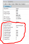
I am using a Mavic Air 2 to shoot panoramas. The drone stitches the panos and includes all the required meta data for google maps. I just load the created file to google maps and it works. My earlier drones (spark, Mavic Pro, Mavic Air) did not work as well. The spark and pro required the pano images to be downloaded to the controller where they were stitched by the GO4 app. The Mavic Air would stitch the pano while it was still flying but it did not include important meta file data. The Air 2 includes the meta data. With my earlier drones I had to edit the meta data using a program called ExifTool GUI. The image below shows the meta data I had to add to the files so that it was recognised by google as a 360 Pano. I would have thought that a Mavic Pro 2 zoom would stitch panos on board and include the required meta data.
1632287609039.png
 
  • Like
Reactions: DronePanorama
I am using a Mavic Air 2 to shoot panoramas. The drone stitches the panos and includes all the required meta data for google maps. I just load the created file to google maps and it works. My earlier drones (spark, Mavic Pro, Mavic Air) did not work as well. The spark and pro required the pano images to be downloaded to the controller where they were stitched by the GO4 app. The Mavic Air would stitch the pano while it was still flying but it did not include important meta file data. The Air 2 includes the meta data. With my earlier drones I had to edit the meta data using a program called ExifTool GUI. The image below shows the meta data I had to add to the files so that it was recognised by google as a 360 Pano. I would have thought that a Mavic Pro 2 zoom would stitch panos on board and include the required meta data.
View attachment 135193
This is really good information, thanks so much!

My M2Z stitches the photos in the craft during flight. I take the panos right off the SD card. But the metadata isn't acceptable to view online with Kuula, Facebook or GM to display property. As I explained, I learned how to alter the metadata for Kuula and Facebook, but the same data didn't work for GM. That's when I gave up, I couldn't find out how to do what you just shared.
I'm surprised your M2P doesn't stitch panos in the craft. I've never had Go4 do the stitching for my M2Z, same craft, different camera. Hmm. I'm unfamiliar how Go4 stitches post flight, since it was automatic in M2Z craft right after all the shots were taken.
Coincidentally I have a new A2S that I have taken a few pano's, but haven't tried to upload to GM. I assumed it wouldn't work because it's a DJI camera. It appears DJI has become aware if the issue for pano viewing compliance and fixed the issue, so I'll have to try uploading one. Too bad they don't fix it in the M2 craft with new firmware, however I wouldn't update the craft firmware anyway because of the new GEO restrictions. That's more important to avoid than gaining panos IMO.

Thanks again!
 
Lycus Tech Mavic Air 3 Case

DJI Drone Deals

New Threads

Forum statistics

Threads
130,983
Messages
1,558,543
Members
159,972
Latest member
valter123