DJI Mavic, Air and Mini Drones
Friendly, Helpful & Knowledgeable Community
Join Us Now

Has anyone tried mapping inside a building?

mikegrad

Well-Known Member
Joined
Dec 29, 2017
Messages
100
Reactions
57
Location
Westchester NY
I was thinking it might be a cool thing to be able to do a 3d map inside a building. Think like a large tennis dome, or indoor soccer fields, etc. It would be a great marketing tool if you could create a 3D model that you could be inside of, vs outside? just wondering if anyone has tried this with something like ODM Lightning, and if it would actually work? you would probably need to fly it manually as GPS wouldnt be available.

thanks
Mike
 
It will work if you can keep signal and use a mapping software like dronelink . keeping signal will be the struggle as to why you might not be able to do that.

One tip : Get your signal first than fly into the building might give you a chance to keep the signal.

Phantomrain.org
Gear to fly in the Rain. Land on the Water

even if you could fly the automated route, I'm thinking that only covers the ground and part of the walls. Im thinking doing the ceiling as well to create the enclosed space. in past mapping missions i've manually taken photos under overhangs and things like that to get good detail on say the side of a house. Could you manually take some photos of the walls, ceilings, etc?
 
You could also consider just doing a 360 as its most likely small enough to capture the ceiling . Keep in mind that even if you could get 18,000 pictures taken to create the 3D image requires some serious computing power.

Phantomrain.org
Gear to fly in the Rain. Land on the Water.
 
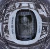
I did what you refer to with an Inspire 1 a few years ago. This stadium is partly covered. We were flying underneath much of the canopy while mapping the field. ATTI mode would come and go. We did acquire a signal first, then started the mission. It was a challenge, mostly because of the Inspire 1. :-0
Today, I think the sensor positioning would be much better.
IMG_1446.jpeg
 
You can map internal structures accurately with the lidar scanner built into the i-phone 12. Very good accuracy and the render is remarkable
 
I am not sure about ODM, but with Metashape you could just use a terrestrial camera for inside, process it as a separate chunk and then combine with the exterior chunk with manual tie points.

It is indoors so you will most likely not have GPS for the terrestrial camera or the drone.

I just have the exterior in a cloud based viewing site, and link to a Matterport tour. It is seamless and actually easier to navigate for clients since they tend to have a nightmare transitioning from indoors to outdoors on 3D models.
 
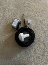
There are GPS repeaters, not to terribly expensive. I have one, not for the drone, but the airplane. Seems everything in the new systems in aircraft want a GPS lock. Makes it virtually impossible to program some systems inside. Which in the winter is not a great time to be outdoors. I think I paid something in the area of $100 for it. It has an antenna you place outside and a re-transmitter you put inside. Takes a few minutes to get its signal going inside.
gps.jpg
 
Lycus Tech Mavic Air 3 Case

DJI Drone Deals

New Threads

Forum statistics

Threads
131,145
Messages
1,560,351
Members
160,116
Latest member
henryairsoft1