DJI Mavic, Air and Mini Drones
Friendly, Helpful & Knowledgeable Community
Join Us Now

help retrieving lost drone

shyke

New Member
Joined
Jan 21, 2023
Messages
3
Reactions
0
Age
51
Location
Israel
Hi guys,

I lost my drone after it enter ATTI mode and somehow lost connection to all satellites.
A few facts:
* Home point was updated when the drone took off.
* During the early stages of the flight, the connection to the remote was lost, reconnected and then lost again for good.
* When the connection first lost, I ran towards the direction of the drone, to maybe get closer and reconnect again.
* After disconnecting the cable from the phone to the remote and connecting it again, the connection to the drone regained and I sent RH command which was acknowledged by the drone.
* I was promoted to select between the original home point and the new one I was at, I selected the new one.
* A few seconds after, the connection lost again for good.
* Reconnecting the cable did not help at this time.
* There was barely no wind on the ground, so drifting in ATTI mode with no connection is maybe minimal.
* I went to the place the drone last reported using find my drone, scanned a large radius and did not find the drone.
* I understand that in ATTI mode were there is no satellite connection, the GPS info is not accurate.

Here is the flight log.

I will appreciate any idea where to look for the drone.
Thank you very much
 
It's not easy to help you find the drone.
You had good GPS until 1:47.9 when your drone was 280 metres away.
When the drone passed 195 metres the numbers of sats rapidly dropped to zero.
Having this happen when you climb beyond a certain altitude could be assocoated with GPS jamming which has been observed several times in your part of the world.
If that was the case, bringing the drone back down probably would have restored GPS reception.

From 2:16 you started losing signal, which should have been a hint to bring the drone back while you could.
But you left it up there and flew for a little longer until the downlink was lost at 2:24.
Downlink was restored four minutes later.

At around 6:50 there were more messages about losing the downlink, but you never completely lost signal which would have cause the drone to autoland wherever it was.

There's no way to know where you flew too because there is no location data at all after GPS was lost.
Without GPS, the drone had no ability to hold position and will have drifted with the wind.
You left the drone drifting until signal was lost at 10:06.5.
Wherever it was at that time, it will have autolanded.


* After disconnecting the cable from the phone to the remote and connecting it again, the connection to the drone regained and I sent RH command which was acknowledged by the drone.
* I was promoted to select between the original home point and the new one I was at, I selected the new one.
It made no difference.
Without GPS, the drone has no idea where it is or where that homepoint is or how to get there.
* I went to the place the drone last reported using find my drone, scanned a large radius and did not find the drone.
FMD can only show you the last place where the drone was able to report its location back to the app.
But you flew the drone for some time after that.
* I understand that in ATTI mode were there is no satellite connection, the GPS info is not accurate.
It's not a matter of not accurate.
It's a case of no location data at all.
 
  • Like
Reactions: GFields
It's not easy to help you find the drone.
You had good GPS until 1:47.9 when your drone was 280 metres away.
When the drone passed 195 metres the numbers of sats rapidly dropped to zero.
Having this happen when you climb beyond a certain altitude could be assocoated with GPS jamming which has been observed several times in your part of the world.
If that was the case, bringing the drone back down probably would have restored GPS reception.

From 2:16 you started losing signal, which should have been a hint to bring the drone back while you could.
But you left it up there and flew for a little longer until the downlink was lost at 2:24.
Downlink was restored four minutes later.

At around 6:50 there were more messages about losing the downlink, but you never completely lost signal which would have cause the drone to autoland wherever it was.

There's no way to know where you flew too because there is no location data at all after GPS was lost.
Without GPS, the drone had no ability to hold position and will have drifted with the wind.
You left the drone drifting until signal was lost at 10:06.5.
Wherever it was at that time, it will have autolanded.


It made no difference.
Without GPS, the drone has no idea where it is or where that homepoint is or how to get there.

FMD can only show you the last place where the drone was able to report its location back to the app.
But you flew the drone for some time after that.

It's not a matter of not accurate.
It's a case of no location data at all.
Thank you very much Meta4 for your kind and informative reply. really appreciate it.
I understand now it is a long shot but I would like to try and search for the drone.
it was really a calm day with no winds so maybe it did not drift far away.
from your knowledge and expertise can you suggest a most likely area/route for search? (it is all open fields there)
Thank you very much again for all your help
 
from your knowledge and expertise can you suggest a most likely area/route for search?
Sorry if I could, I would have but this one doesn't have enough clues to work with.
 
...sent RH command which was acknowledged by the drone.
No RTH phase is recorded in the log... your drone was in only 2 modes during this flight, P-mode (ordinary GPS mode) & ATTI mode.

* There was barely no wind on the ground, so drifting in ATTI mode with no connection is maybe minimal.
This was the different wind speeds calculated out from your M2P's attitudes by Airdata.com...
1674307801800.png

If investigating your made stick inputs from the last known position (where ATTI started), we see that you nearly exclusively made elevator inputs up to the point when the connection was lost... in other words, your M2P continued in the same direction as the earlier recorded flight path. Everything after the ATTI mode had started, consisted of either a continued flight in the same earlier direction or drifting in the wind direction (due to being in ATTI). The wind direction on the height your M2P was, almost perfectly lined up with the earlier recorded flight path... so you either flew or drifted in the same direction.

This is the facts we can work with... taken either from the M2P specs & from the log...

-3m/s descent speed (according to the specs)
-12m/s in max elevator stick command (according to the specs)
-Adding up those seconds after you came in ATTI where you applied full elevator input:

(1,7+2,5+0,6+10,5+1,0+0,3: total 16,6s full forward from last known position)
-Adding up those seconds after you came in ATTI where you let the M2P just drift with the wind:
(13,5+461,2: total 474,7s in drift (wind speed) from last known position)
-Wind speed 7,9m/s up on max height before landing (in a direction of 208 degrees, coming from log recorded tilt angle before going into ATTI)

This gives:
Distance with full elevator applied 166m
Distance with drift up on max height, either neutral sticks or disconnect 3750m

And to this add the time for landing from a 189,8m height... drifting in an average wind speed on the way down of 6,6m/s...

Drift distance for landing (63,2s) 417m

In total: Distance from last recorded position may be 4333m before the M2P touched ground...


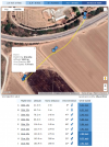
If drawing out this on a Google Earth map, it could have been like this... your M2P could be as far away out where the red cross is.

All above is very imprecise due to lack of real proper data... it just gives you a picture of how far out your M2P could have gone.

(Click on the pic to make it larger)
1674309800853.png


*EDIT*

Might add...

Was initially a bit puzzled about why the M2P didn't land during that longer "disconnect" (461,2s) shown in the log (if in ATTI & looses the connection a DJI drone lands)... but I imagine that the reason was that it was there you fiddled with the USB cable & just disconnected the mobile device (& by that stopped the recording)... the RC & M2P was still connected.

If you let the M2P drift during those 461,2s without stick inputs, the above calculation stick... if you made inputs, all above gets an unknown variable of flight in an unknown direction & falls flat.
 
Last edited:
  • Like
Reactions: GFields and Yaros
No RTH phase is recorded in the log... your drone was in only 2 modes during this flight, P-mode (ordinary GPS mode) & ATTI mode.


This was the different wind speeds calculated out from your M2P's attitudes by Airdata.com...
View attachment 159752

If investigating your made stick inputs from the last known position (where ATTI started), we see that you nearly exclusively made elevator inputs up to the point when the connection was lost... in other words, your M2P continued in the same direction as the earlier recorded flight path. Everything after the ATTI mode had started, consisted of either a continued flight in the same earlier direction or drifting in the wind direction (due to being in ATTI). The wind direction on the height your M2P was, almost perfectly lined up with the earlier recorded flight path... so you either flew or drifted in the same direction.

This is the facts we can work with... taken either from the M2P specs & from the log...

-3m/s descent speed (according to the specs)
-12m/s in max elevator stick command (according to the specs)
-Adding up those seconds after you came in ATTI where you applied full elevator input:

(1,7+2,5+0,6+10,5+1,0+0,3: total 16,6s full forward from last known position)
-Adding up those seconds after you came in ATTI where you let the M2P just drift with the wind:
(13,5+461,2: total 474,7s in drift (wind speed) from last known position)
-Wind speed 7,9m/s up on max height before landing (in a direction of 208 degrees, coming from log recorded tilt angle before going into ATTI)

This gives:
Distance with full elevator applied 166m
Distance with drift up on max height, either neutral sticks or disconnect 3750m

And to this add the time for landing from a 189,8m height... drifting in an average wind speed on the way down of 6,6m/s...

Drift distance for landing (63,2s) 417m

In total: Distance from last recorded position may be 4333m before the M2P touched ground...


If drawing out this on a Google Earth map, it could have been like this... your M2P could be as far away out where the red cross is.

All above is very imprecise due to lack of real proper data... it just gives you a picture of how far out your M2P could have gone.

(Click on the pic to make it larger)
View attachment 159754


*EDIT*

Might add...

Was initially a bit puzzled about why the M2P didn't land during that longer "disconnect" (461,2s) shown in the log (if in ATTI & looses the connection a DJI drone lands)... but I imagine that the reason was that it was there you fiddled with the USB cable & just disconnected the mobile device (& by that stopped the recording)... the RC & M2P was still connected.

If you let the M2P drift during those 461,2s without stick inputs, the above calculation stick... if you made inputs, all above gets an unknown variable of flight in an unknown direction & falls flat.

Slup i am so grateful for your comprehnsive analysis and effort. Thank you for taking the time to give such an elaborate and educative answer.
Wow I have not imagined it could drift so far. I went earlier today to look out for the drone but searched a radius of up to 1km from where it lost connection. now seeing your answer I see I wasn't even close (-:
I will try again where you pointed out. hopefully a miracle will come through.
All the best,
Shy cohen
 
Was initially a bit puzzled about why the M2P didn't land during that longer "disconnect" (461,2s) shown in the log (if in ATTI & looses the connection a DJI drone lands)... but I imagine that the reason was that it was there you fiddled with the USB cable & just disconnected the mobile device (& by that stopped the recording)... the RC & M2P was still connected.
The data says Downlink lost ... downlink restored, so the uplink was still there and signal was not totally lost until the end.
 
Lycus Tech Mavic Air 3 Case

DJI Drone Deals

New Threads

Forum statistics

Threads
130,974
Messages
1,558,486
Members
159,964
Latest member
swigmofa