DJI Mavic, Air and Mini Drones
Friendly, Helpful & Knowledgeable Community
Join Us Now

How to get white parts of image out of finished product?

Surveying BML

New Member
Joined
Oct 21, 2021
Messages
4
Reactions
0
Age
34
Location
Missoula, MT
Hello,

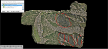
I am trying to edit photogramatric data so it does not have the white parts in the photo. We flew the west and east sides of this ranch with our Matrice 300, with zenmuse camera and on the east side data there is white parts for some reason? Does anyone knoe what causes this?

We post procesed data in Pix4D and then brought it into global mapper.


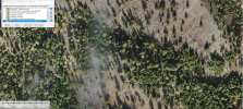
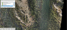
Another question I have is, The west side data is not as great quality as east side? do you know what could have caused this and how we could match the image qualities better?
 

Attachments

  • Drone troubleshoot data.png
    Drone troubleshoot data.png
    2.1 MB · Views: 50
How high was the drone? It looks like fog or clouds. Both the white areas and sharpness of select areas could be improved in Photoshop. Resolution of the attached images is only 20x9 @96dpi. When blown up to 200% it was already becoming a bit pixelated. What's the max size/resolution available? What do you mean by "different quality?

This was done with a mapping pattern of flight? If so, you have to remember that sections were probably captured at different times with different exposures. What is it that you would want done exactly?
 
The drone was at 70 meters I believe. Clouds did come over at some point but they wouldn't have been under the drone. We were thinking the exposure would have been off because different parts were flown at different times through out the day. The actual file size is about 2.3 GB, I apologize for not knowing the actual resolution. The west side just looked a little blurry when zoomed in on global mapper. It could have been a processing thing in Pix4D, we are very new to drone processing data so it could have been a setting we missed.

This was a drone mapping with terrain follow on and about 6 flights total. The photo shop route, what software would you reccommend and with what tools would we use to try to clear up the white areas?
 
Smoke? In any case, if smoke or fog, there's really no way to easily mask it. Pretty sure there are algorithms that can, but access may be expensive. And if the smoke obscures something on the ground, well, you can't get something from nothing. So whatever is under the smoke is essentially lost.
 
No it definitely wasn't smoke. It was a blue bird day with hardly any clouds around. There was one time of day when some clouds came in and shaded an area but, it only lasted maybe 10 minutes and we were out there for about 8 hours.
 
Here is a zoomed in picture of where the problem area is.
 

Attachments

  • Zoomed in Troubleshooting .png
    Zoomed in Troubleshooting .png
    4 MB · Views: 22
  • Zoomed in Troubleshooting 2 .png
    Zoomed in Troubleshooting 2 .png
    3.7 MB · Views: 22
Two areas of a tree shadow:

Zoomed in Troubleshooting2.png
Clearly there is a change in shadow density, something is occluding the ground. If you can see such a change within a single image, pretty clear evidence of smoke or mist.

There's a chance the camera was changing exposure, or something in your post processing is changing the camera contrast - I'm basing this on the assumption the black rectangles on the far right in one of your samples being the actual camera view captured.
 
Last edited:
..
It looks like fog or clouds.

I was also thinking similarly, mist / higher humidity forming in gullies and moving up the ridges.

I'm not a Pix4D user, but I love the newsletters they send, and know they have a forum community.
It would be great to ask there I am reasonably sure you will get more experienced replies (just that I haven't seen many Pix4D posts here in the past).

The community forum there gets replies from Pix 4D staff too.

It's not easy to navigate, but I'll just go find the general Questions / Troubleshooting section for you . . .

PIX4Dcapture

There are lots of sections for individual Pix4D tools so go up a menu to the main one (Community link up top bar, left) and look through to see if there might be a better section.
 
Does that occur in every photo you take or just these few? The fact that the image is noticeably more blurry under those areas and how they look in the image makes me think it's mist or fog as well, even if it may not have been noticeable to you while flying. If it doesn't occur in every photo or during controlled testing, you can rule out a hardware issue.

Assuming you don't need that data to be 100% accurate beneath those small areas, content-aware fill in Photoshop would make short work of those in a few clicks, or the clone tool from a similar area on the image. With these being survey images though I realize they may need to remain 100% accurate.
 
I’m wondering if it’s an issue with the stitching of the photos. Just a thought.
Regards
 
The drone was at 70 meters I believe. Clouds did come over at some point but they wouldn't have been under the drone. We were thinking the exposure would have been off because different parts were flown at different times through out the day. The actual file size is about 2.3 GB, I apologize for not knowing the actual resolution. The west side just looked a little blurry when zoomed in on global mapper. It could have been a processing thing in Pix4D, we are very new to drone processing data so it could have been a setting we missed.

This was a drone mapping with terrain follow on and about 6 flights total. The photo shop route, what software would you reccommend and with what tools would we use to try to clear up the white areas?
With Photoshop I would use... Photoshop. Technique? I'm not sure, but there are always 3 or more ways to do anything in Photoshop. It all depends on what's needed. There is a dichotomy in Photoshop that I want to share with you and those interested...

"THINGS THAT APPEAR EASY ARE OFTEN DIFFICULT AND THINGS THAT APPEAR DIFFICULT ARE OFTEN EASY"

... ergo a lot of times I don't know what it will take until it's time to do the work.
 
from the shadows it was early morning or later evening, both times when you could get some low level fog forming in the depression/valley areas of the imaged area. To avoid this either fly later if morning and earlier if evening, to avoid the atmospherics that will cause this mist/fog forming. Alternatively, fly on a day that the temperature and dew point are such that will avoid this situation.

As for removing white spots, that is very simple in Photoshop, if you know Photoshop. You can use the clone tool or the healing brush or the stamp or other things, depending on what version of photoshop you have. PM me if you need detailed instructions and I can walk you through it.

One further point, if you are flying over an 8 hour period and then wanting to stitch something together from various shots during that 8 hour period, that is just not going to be possible, due to the change in shadow size and angle, from trees and hills in the terrain, as well as the difference in the light throughout the day, regarding temperature (Degrees Kelvin) and intensity.
 
Last edited:
Lycus Tech Mavic Air 3 Case

DJI Drone Deals

New Threads

Forum statistics

Threads
130,588
Messages
1,554,140
Members
159,592
Latest member
MaxRichu