DJI Mavic, Air and Mini Drones
Friendly, Helpful & Knowledgeable Community
Join Us Now

How to Judge Winds Quickly with your Drone !

The best way used to be ATTI mode...

Atti mode can with much caution I might add . be used to determine the direction of the wind but not how strong the winds are.

With that said if it is really windy , Atti mode should be your last resort.

Phantomrain.org
Gear to fly your Air 2 in the Rain and Float on water.
 
Last edited:
Here is the Mini 2 engaging 12 to 15 mph winds seen with the Hover test.
Mini 2 is geared up with the New improved Wet Suits for the Heavy Rain. .

Notice how because the winds are constant they appear to be stronger than they really are .
The drone holds 2 ft on the hover spot if I were to fly at 200 ft this would be the cut off 2 1/2 drift and I would not attempt , as the first risk would be a forced landing do to Esc error and the second issue would be the landing itself .
The drone hover test shows these winds to be 12 to 15 mph winds.

Phantomrain.org
Gear to fly your Mavics in the Rain and Float on water.

 
Having spent around $NZ2200 on the Mavic Air 2 Fly More Combo plus some extra accessories and run it off a new iPhone 11 Pro, I have absolutely zero intention or interest in poking it up in a torrential downpour with a high chance of a blow away, also! Similarly any of my other expensive Nikon and Sony camera gear. And if I owned a Ferrari, it would not be doing spins along a salty beach flat ........ ?????????? I will just sit back and enjoy seeing somebody else’s hurricane weather shots!
Hi David,
I lived in T'ga from early 1988 'till my return 'home' to Oz January 2008 ?
You live in a Very Special Place. ?
Recently I purchased the Mavic Air 2 combo, plus extras. But so far I have only recently started learning to fly it. I'm within 5 1/2 kms and under the local flight path, so have to go around 25 kms away (west) and practice on a small country sports playing field.
However I think in Tauranga there would be several scenic safe flying areas to visit.
When you start putting up videos please let me know. (Nothing wrong with a good dose of homesickness).
Coffs Harbour is in several ways a parallel to T'ga. I must check out it's airspace restrictions.
I too have no intention of putting my drone nor the public at risk.
 
Theoretically the speed of the craft shown on the APP interface = speed of the wind if no stick input is applied. I am going to try it out on my M2P.
Exactly. GPS still used for telemetry, just not for flight control while in ATTI. I've done it with my P3.

Note though if you force ATTI by covering GPS reception, then there's nothing to record speed. You also risk loss since you can't get GPS back for stabilization or RTH.
If you can safely get low enough, then you have VPS.
 
More valuable information. This apply to DJI Go 4 App.
 
More valuable information. This apply to DJI Go 4 App.
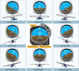
The video is wrong about the direction of the attitude indicator. E.g. the craft should be banking to the left ( left side lower ) if the attitude indicator is like this :

1605851816699.png
 
I hate to disagree but the video looks right. This video is made by DJI.
 
I hate to disagree but the video looks right. This video is made by DJI.
You can check it out with your drone. The attitude indicator is actually mimicking the artifical horizon on a real aircraft. If the horizon has the right side down as shown in my post, the craft is tilted to the left. From Attitude indicator - Wikipedia :

1605852465745.png
 
Last edited:
You can check it out with your drone. The attitude indicator is actually mimicking the artifical horizon on a real aircraft. If the horizon has the right side down as shown in my post, the craft is tilted to the left. From Attitude indicator - Wikipedia :
Phantomrain.org


So the problem with this is that this is not true for DJI

Here is why
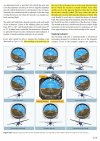
Most banking scale indicators on the top of the instrument move in the same direction from that in which the aircraft is actually banked. Some other models move in the opposite direction from that in which the aircraft is actually banked. This may confuse the pilot if the indicator is used to determine the direction of bank.

Phantomrain.org
Gear to fly in the rain
 
1.jpg
 
The camera is right. The instrument represent the drone angle, not the horizon angle.
 
1) Follow Mode: The angle between the gimbal’s orientation and aircraft’s nose remains constant at all times.
2) FPV Mode: The gimbal will synchronize with the movement of the aircraft to provide a first-person perspective flying experience.
The difference between Follow Mode and FPV Mode is that the image transmission screen will tilt when the left sticks are pushed to the left or right in FPV Mode while the image transmission screen will not in Follow Mode.
 
This is what is great about this forum. You can learn more about flying the drone in all kinds of condition.
I really appreciate seeing the videos but the older I get the less likely I will be out in rain, wind, or the cold.
But I am suited up for it if I change my mind or I am just so bored (or crazy) to want to go out in it.
When flying your drone, in some areas you never know when storm will blow in and I would want to be prepared for it.
One thing I did realize with some of the posts on this forum, I would rather be safe then sorry.
But that is just my opinion.
 
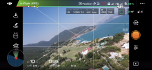
Tried out two ways to determine wind speed and direction with my M2P today :

1) switch the craft to ATTI mode. Release all sticks and let the craft drift with the wind
2) point the camera to the front leg. Turn one round and observe the position change of the front leg in the camera's view

Both methods seem to work quite well. For the ATTI mode, the measured wind speed and direction match quite well with that measured by the anemometer of the government weather station there ( the small white tower in the video )

 
  • Like
Reactions: itsneedtokno
Lycus Tech Mavic Air 3 Case

DJI Drone Deals

New Threads

Forum statistics

Threads
130,583
Messages
1,554,086
Members
159,587
Latest member
Bigbrute