DJI Mavic, Air and Mini Drones
Friendly, Helpful & Knowledgeable Community
Join Us Now

Incorrect METAR AND TAF

Unit0505

Member
Joined
Mar 21, 2022
Messages
5
Reactions
1
Age
52
Location
Shreveport
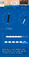
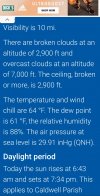
Still studying for my Part 107 and I'm curious if I'm wrong or if my local airport Metar and Taf are wrong. I'm watching the weather this morning and I observed a local communication tower that is 1,985 agl, 2049 msl and was only half visible. The upper half was completely hidden in the clouds. According to Metar and Taf, clouds were broken at 2,900ft and overcast at 7,000. This shouldn't affect my flight up to 400ft, but with the 500ft buffer below cloud level, it appeared to be pretty close. I'm really curious as to whether or not metars and tafs are wrong often, were they wrong or do I need to do some more studying?Screenshot_20220411-082445_Chrome.jpgScreenshot_20220411-082330_Chrome.jpg
 
I was watching weather coming into several airports last night, and since the METARs are at hour intervals, I wouldn't be trusting the METARs.
 
Still studying for my Part 107 and I'm curious if I'm wrong or if my local airport Metar and Taf are wrong. I'm watching the weather this morning and I observed a local communication tower that is 1,985 agl, 2049 msl and was only half visible. The upper half was completely hidden in the clouds. According to Metar and Taf, clouds were broken at 2,900ft and overcast at 7,000. This shouldn't affect my flight up to 400ft, but with the 500ft buffer below cloud level, it appeared to be pretty close. I'm really curious as to whether or not metars and tafs are wrong often, were they wrong or do I need to do some more studying?View attachment 146597View attachment 146598
May not want to be flying when LGT DSNT is on there. Also dew point is closing in with 88% humidity.
 
In addition to the timing described above, your location is presumably not exactly the same as where the airport observation is taken. Cloud bases are not flat, so even a short distance away you might experience differences from what the METAR reports.
 
METARs are actual measured data at an airport at hourly intervals. They are 100% accurate at the time they are issued for that location. You should go to the transport authority source to read the data, who knows what a third party app does with the data.
 
Unless you're flying AT the AIRPORT and AT the time of the reading it's just background information for you to use as a tool to help ESTIMATE your weather. The only weather that matters is where your aircraft is flying.
 
Unless you're flying AT the AIRPORT and AT the time of the reading it's just background information for you to use as a tool to help ESTIMATE your weather. The only weather that matters is where your aircraft is flying.
fuel_guage_accuracy.jpg


This is no time to finding out the headwinds changed over an hour ago.
 
The info I posted came from Metar-taf.com. it was the same information from several different sites. The Metar was issued at the same time that I was watching the conditions. I wasn't getting ready to fly at that time, just making an observation while driving down the highway and decided to see what the metar or taf showed for clouds. I've made it a habit of identifying towers and other structures on sectional charts just to be more proficient and to check TFR 's and weather data.
 
  • Like
Reactions: BigAl07

DJI Drone Deals

New Threads

Members online

No members online now.

Forum statistics

Threads
134,578
Messages
1,596,448
Members
163,078
Latest member
dewitt00
Want to Remove this Ad? Simply login or create a free account