DJI Mavic, Air and Mini Drones
Friendly, Helpful & Knowledgeable Community
Join Us Now

LAANC discrepancy in different Apps

JerryM

Member
Joined
Nov 24, 2019
Messages
16
Reactions
10
Age
71
Location
USA
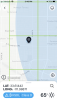
I've been flying my drones around my property since November after checking B4UFLY. It showed me .96 miles from any restricted areas. Airmap shows the same, but Kitty hawk shows I need LAANC approval. Why the discrepancy and which one should I believe. I searched for answers to this question before I posted hoping not to double up. Any help would be appreciated.
 
  • Like
Reactions: Bekanne
Kittyhawk & B4UFLY should show the same thing, B4UFLY is powered by Kittyhawk. What does Kittyhawk show for a warning and does the map show a light blue shaded area over your location? I live ~.5 mile inside of Class D airspace and the there's an area within the square on Kittyhawk that is safe to fly without getting LAANC authorization.
 

Attachments

  • File Feb 25, 3 41 16 PM.png
    File Feb 25, 3 41 16 PM.png
    306.4 KB · Views: 12
I noticed something like this, too. For a spot just outside of the local airport's range, B4UFly shows clear and ready to fly, but KittyHawk shows I need to make a request (I can't use LAANC, as my local airport doesn't have LAANC . . . yet?). It seems to be because KittyHawk uses this boxed method thing, and you can see on the attached, one box barely touches the outer ring of the airport range, but the entire box will get you a warning to get permission to fly. First image is B4UFly, next two are KittyHawk of the same area.

I would give preference to B4UFly, as that's the official FAA app.

B4UFly.pngKittyHawk1.pngKittyHawk2.png
 
Lot's of discrepancies because "Authorization Apps" and the Facilities Grid use Rectangles to depict sections within ROUND airspace... most of us learned many years ago that concept doesn't work.

Legally you go by the AIRSPACE your aircraft is operating in (or you intend to) so you want to use something that accurately depicts the exact airspace.
 
@JerryM .. you could apply through the FAA’s DroneZone and receive up to two year’s flight clearance for the area. I have one covering over 2 square miles and encompasses NFZs for a busy but small local airport and a regional hub.
I found it the easiest way.
 
  • Like
Reactions: FlyingHevy
I understand that Kittyhawk and B4UFLY are the same, but as you can see in the screen shots below Kittyhawk has boxes outside the radius. Am I looking at this wrong in that if it's in a box but outside the circle it is still required to make a request to fly?Screenshot_20200225-165050.pngScreenshot_20200225-164918.png
 
I understand that Kittyhawk and B4UFLY are the same, but as you can see in the screen shots below Kittyhawk has boxes outside the radius. Am I looking at this wrong in that if it's in a box but outside the circle it is still required to make a request to fly?
Can you post screenshots showing numbers in the squares?
 
BigA107,
Thank you for the clarification. As a retired tradesman I know the problems of trying to fit a round peg in a square hole, I just wanted to make sure I wasn't missing something.

Jerry.
 
@JerryM .. you could apply through the FAA’s DroneZone and receive up to two year’s flight clearance for the area. I have one covering over 2 square miles and encompasses NFZs for a busy but small local airport and a regional hub.
I found it the easiest way.
This sounds awesome. From reviewing dronezone itself I thought I had to choose a specific date and time to fly, although I'll admit I hadn't dug too deeply into it yet. I assume that I need to apply only for altitude below what is permitted (kittyhawk says the permissible altitude for authorization is 100 feet)? I'd take that to be able to walk out my back door and fly around a little bit!
 
  • Like
Reactions: Thomas B
This sounds awesome. From reviewing dronezone itself I thought I had to choose a specific date and time to fly, although I'll admit I hadn't dug too deeply into it yet. I assume that I need to apply only for altitude below what is permitted (kittyhawk says the permissible altitude for authorization is 100 feet)? I'd take that to be able to walk out my back door and fly around a little bit!
DroneZone/FAA will want latitudes and longitudes defining the area, but can help you there if you ask.
 
  • Like
Reactions: FlyingHevy
I understand that Kittyhawk and B4UFLY are the same, but as you can see in the screen shots below Kittyhawk has boxes outside the radius. Am I looking at this wrong in that if it's in a box but outside the circle it is still required to make a request to fly?View attachment 95108View attachment 95109
The magenta colored bit is what you need to be concerned with. That little bit that's in the upper part of your location square is the culprit. Kittyhawk will report anything in that square as within the airspace due to the grid they overlay on the airspace. The grid is used to differentiate ceiling limits within the airspace. You're good to fly without authorization as long as you stay out of the magenta airspace.
 
Lycus Tech Mavic Air 3 Case

DJI Drone Deals

New Threads

Members online

Forum statistics

Threads
131,110
Messages
1,559,925
Members
160,087
Latest member
O'Ryan