

Hi there, flying a mission with Litchi today and got a "strong wind" warning and then the drone "disconnected". Didn't return home and no idea why. I have tried to attached the flight log from the Litchi app, but seem unable to attach the csv file Any help would be very much appreciated
You are using an out of date browser. It may not display this or other websites correctly.
You should upgrade or use an alternative browser.
You should upgrade or use an alternative browser.
Lost Drone
- Thread starter davidpat
- Start date
Posting your data is necessary if you want anyone to see what might have happened.Hi there, flying a mission with Litchi today and got a "strong wind" warning and then the drone "disconnected". Didn't return home and no idea why. I have tried to attached the flight log from the Litchi app, but seem unable to attach the csv file Any help would be very much appreciated
You could follow the instructions here: DJI Flight Log Viewer | Phantom Help
.. to upload your Litchi data to Phantomhelp and then post a link to the Phantomhelp report.
It would also be helpful to post something to show details of the waypoint mission, so we know what you had programmed to drone to do.

Posting your data is necessary if you want anyone to see what might have happened.
You could follow the instructions here: DJI Flight Log Viewer | Phantom Help
.. to upload your Litchi data to Phantomhelp and then post a link to the Phantomhelp report.
It would also be helpful to post something to show details of the waypoint mission, so we know what you had programmed to drone to do.
Thank you for your response, I have followed your instruction and used Phantom Help. This is the link for the flight log
DJI Flight Log Viewer | Phantom Help
Upload and view flight logs from your DJI drones
 www.phantomhelp.com
Unfortunately I deleted the waypoint mission in Litchi before I saw your response. Not sure of there is a way to retrieve this. Thanks again
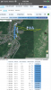
It seems that the disconnection was due to the signal being blocked by the trees right in front of you. The vertical green line is the take off path. The yellow line is the path flown by the craft when executing the waypoint mission. You can see that the path goes behind the trees.

The wind was strong but should not have caused much problem because it was blowing towards the home point. It's possible that you have set the action to something other than return to home when the connection is lost.
The wind was strong but should not have caused much problem because it was blowing towards the home point. It's possible that you have set the action to something other than return to home when the connection is lost.
Last edited:
This looks like quite a puzzle, with a few important pieces missing.Thank you for your response, I have followed your instruction and used Phantom Help. This is the link for the flight log
DJI Flight Log Viewer | Phantom Help
Upload and view flight logs from your DJI drones
Unfortunately I deleted the waypoint mission in Litchi before I saw your response. Not sure of there is a way to retrieve this. Thanks again
Common reasons for non-returning drones include:
Wind too strong and wrong direction for the return flight
Not enough battery for the return flight
Obstacles on the return path
Drone hardware issue
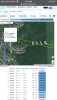
Normally I look for hints regarding wind speed where the flyer leaves the drone hovering, but with the waypoint mission, there's no hovering and no indication of how hard it was being flown to help guage this.
I'm not sure where the drone was programmed to fly past the end of data, but looking around on Google Earth in all directions from there, I think we can rule out obstacles.
There is one glaring problem in the battery department.
The battery was showing 49% at launch and two cells were already at critical low level under load on the climb, only 10 seconds into the flight.
This is not a good sign.
Can you help with a few pieces of the puzzle?
How far was the mission?
The drone was only flying at 9-10 mph at end of data.
What speed was set for the mission?
Do you remember what direction the wind was blowing?
It was a Litchi waypoint mission.It's possible that you have set the action to something other than return to home when the connection was loss.
The Litchi default loss of signal action is to continue flying the mission.
The mission was around 12 mins in total. The speed set was 12km/ph for the mission. Cant remember the exact wind direction but the prevailing wind is from the N/W. Thanks for assistanceThis looks like quite a puzzle, with a few important pieces missing.
Common reasons for non-returning drones include:
Wind too strong and wrong direction for the return flight
Not enough battery for the return flight
Obstacles on the return path
Drone hardware issue
Normally I look for hints regarding wind speed where the flyer leaves the drone hovering, but with the waypoint mission, there's no hovering and no indication of how hard it was being flown to help guage this.
I'm not sure where the drone was programmed to fly past the end of data, but looking around on Google Earth in all directions from there, I think we can rule out obstacles.
There is one glaring problem in the battery department.
The battery was showing 49% at launch and two cells were already at critical low level under load on the climb, only 10 seconds into the flight.
This is not a good sign.
Can you help with a few pieces of the puzzle?
How far was the mission?
The drone was only flying at 9-10 mph at end of data.
What speed was set for the mission?
Do you remember what direction the wind was blowing?
It was a Litchi waypoint mission.
The Litchi default loss of signal action is to continue flying the mission.
It looks like a picturesque area for flying.
But the drone was making a fairly steady 9.5 mph up 175 ft.
This suggests a stiff tailwind on the flight we have data for, which would mean that the drone had to turn around sometime and make way against a headwind to come home.
Where as it heading after the data stopped?
What was the shape of the mission?
Was it a straight line out and back, round a square or something
Total mission length was 12 mins x 12 km/h = 2.4 km
At end of data, the battery was running down at approx 11 sec/percent and had just hit 30%.
It will have reached critical low voltage in perhaps 2-3 minutes and could not have completed the mission with the battery at that level..
On reaching critical low voltage the drone will have landed.
If the drone continued the mission until the battery was too low, it will have landed where it was.
If it attempted to return home on reaching low battery level, it might have had trouble with the headwind and not made it all the way back.
The set mission speed was 12km/h = 7.5 mphThe mission was around 12 mins in total. The speed set was 12km/ph for the mission. Cant remember the exact wind direction but the prevailing wind is from the N/W.
But the drone was making a fairly steady 9.5 mph up 175 ft.
This suggests a stiff tailwind on the flight we have data for, which would mean that the drone had to turn around sometime and make way against a headwind to come home.
Where as it heading after the data stopped?
What was the shape of the mission?
Was it a straight line out and back, round a square or something
Total mission length was 12 mins x 12 km/h = 2.4 km
At end of data, the battery was running down at approx 11 sec/percent and had just hit 30%.
It will have reached critical low voltage in perhaps 2-3 minutes and could not have completed the mission with the battery at that level..
On reaching critical low voltage the drone will have landed.
If the drone continued the mission until the battery was too low, it will have landed where it was.
If it attempted to return home on reaching low battery level, it might have had trouble with the headwind and not made it all the way back.
Thank you for this, I can roughly remember the direction of the mission so can estimate where the critical level may have been reached. I will take a walk and see if I have any luck. I assume nobody knows if it is possible to retrieve a deleted mission in Litchi. Thanks again for the supportIt looks like a picturesque area for flying.
The set mission speed was 12km/h = 7.5 mph
But the drone was making a fairly steady 9.5 mph up 175 ft.
This suggests a stiff tailwind on the flight we have data for, which would mean that the drone had to turn around sometime and make way against a headwind to come home.
Where as it heading after the data stopped?
What was the shape of the mission?
Was it a straight line out and back, round a square or something
Total mission length was 12 mins x 12 km/h = 2.4 km
At end of data, the battery was running down at approx 11 sec/percent and had just hit 30%.
It will have reached critical low voltage in perhaps 2-3 minutes and could not have completed the mission with the battery at that level..
On reaching critical low voltage the drone will have landed.
If the drone continued the mission until the battery was too low, it will have landed where it was.
If it attempted to return home on reaching low battery level, it might have had trouble with the headwind and not made it all the way back.
DrizzyDrones
Well-Known Member
Thanks very much. I used Litchi and I could only get a csv file which I converted XLS. However i was still unable to upload to this site. I have included a link to the shared file if that is any good. Thanks againI have a enterprise Airdata account if u uploaded the txt file I could get the in flight wind info and show a map of where gusts happened like this

DrizzyDrones
Well-Known Member
do u have an air data account? U can uplod litchi log to your air data and i can download it wheres the csv file
Don't have an air data account but could get one . Here is the link to the csv filedo u have an air data account? U can uplod litchi log to your air data and i can download it wheres the csv file
OneDrive
 1drv.ms
Similar threads
- Replies
- 17
- Views
- 2K
- Replies
- 30
- Views
- 3K
- Replies
- 41
- Views
- 6K
- Replies
- 24
- Views
- 2K


DJI Drone Deals
1. Mini 2
2. Mini 3 Pro
3. Mini 4 Pro
4. Air 2s
5. Air 3
6. Avata 2
7. Mavic 3 Pro
8. Mavic 3 Classic
2. Mini 3 Pro
3. Mini 4 Pro
4. Air 2s
5. Air 3
6. Avata 2
7. Mavic 3 Pro
8. Mavic 3 Classic
New Threads
-
 Mini 4 Posting for posterity, my first Hyperlapse
- Started by Feek
- Replies: 0
-
 2 Pro Exploring the Fire Mine: Secret tunnels and dark arcades
- Started by wind-up
- Replies: 0
-
-

-
Members online
Total: 880 (members: 16, guests: 864)
Forum statistics
