DJI Mavic, Air and Mini Drones
Friendly, Helpful & Knowledgeable Community
Join Us Now

Maiden flight - wow - and questions

G’day from Sydney.

As long as you take-off and hover briefly at around 7 to 8-metres and there are sufficient GPS satellites in view, your home point should have been accurately recorded. I’m flying a Mavic 2 Pro and RTH lands in the middle of the landing pad every time.

And that's why it's almost twice as much .
 
Fullbore, that’s exactly what I ordered, direct from DJI, 8 days ago. Its a long story with customs delays in Memphis, but scheduled to arrive Dallas this Friday, a total of about 11 days if it stays on schedule. From what I’ve read, others have experienced the same frustrations I’ve had when trying to make sense of the FedEx tracking thing, but as of today, I‘m still on the expected date FedEx originally provided me. I think FedEx anticipates these types of things and builds that into their schedule estimates.
This morning, FedEx tracking shows this was shipped yesterday and should arrive Thursday. We’ll see...

edit 4:30 pm cst: now see that item not yet shipped, no pick up by FedEx. Only paper work submitted to create shipping label.
 
Last edited:
Welcome to the forum from the beautiful woods of Maine!
The map in the lower left corner will give you the drone orientation and a line from the homepoint to help return it to the launch location.
 
  • Like
Reactions: hiflyer201
I disagree RTH is yes for emergencies but also ease of use....IMO
I agree with you that it is also intended for ease of use. That said, I personally almost never use auto anything for flying. Learning to bring it back home using your eyes and telemetry as well as landing in the "right" spot is an important skill you may need in the event something goes wrong. The more you practice the more natural it will be. In case of an "emergency" people generally panic and don't think straight, and the more something is routine, the easier it will be to do under pressure.
 
  • Like
Reactions: A.O.
Hello Jarnie:

Congratulations on your first flight. Great advice up thread from many experienced fliers.

To summarize points made in several different previous posts:

Return to Home (RTH) and Precision Landing (PL) are related, but different. Return to Home depends upon GPS signals to get your drone back to a small area that includes your takeoff point. When your display or audio tells you that RTH has been updated, that means GPS coverage and the received signal has combined to identify that area. As long as everything else goes correctly, your drone should be able to find that area when a RTH event is requested - either by you or an automated function.

Precision Landing depends on RTH to get to the takeoff area and then uses the downward sensors to match a stored image of the precise takeoff point that your drone recorded as it climbed up upon takeoff. That’s why PL functions best when you ascend straight up for 7 or so meters upon takeoff. I don’t think there is any indication (audio or visual) that your drone has recorded an image that will result in a precise landing.

As others have mentioned, using RTH to get to the takeoff area and then manually landing your drone on the pad are good skills to master. I manually land in two ways (or a combination of both) - Watch the drone directly without looking at the controller and bring her down into the center of the pad or tilt the gimbal straight down and watch the controller as I descend the drone to the center of the pad. For the latter I find using the grid and “X” overlays on the camera helpful.

Keep flying and let us know how it goes!

Howard
 
Keep your drone away from tree's and yourself near them. Shade is your friend. You should familiarize yourself completely with RTH (I'm guilty of not doing that) but then use it as a last resort.
As Laborous stated..use the small map in the lower left corner. It shows a direct line home. Glance at it from time to time just to increase your situational awareness and practice lining up with it a few times. Once you're comfortable doing that I'm sure you'll forget about automatically using RTH.. After all ..we bought the drone to fly not push buttons. LOS is a requirement but it is very easy to lose.
 
  • Like
Reactions: A.O.
Keep your drone away from tree's and yourself near them. Shade is your friend. You should familiarize yourself completely with RTH (I'm guilty of not doing that) but then use it as a last resort.
As Laborous stated..use the small map in the lower left corner. It shows a direct line home. Glance at it from time to time just to increase your situational awareness and practice lining up with it a few times. Once you're comfortable doing that I'm sure you'll forget about automatically using RTH.. After all ..we bought the drone to fly not push buttons. LOS is a requirement but it is very easy to lose.
I'm going to have to check out that little map and the orientation it affords. I know its there but never really paid attention to it.
 
  • Like
Reactions: hiflyer201
Well after purchasing my MA2 longer ago than I want to divulge for many reasons such as too windy, too busy and nervous I did my maiden flight this morning in the middle of a large playing field nearby in the Blue Mountains. I checked the map in cache and verified that the 'home' location was where I was located and then flew for about 20 minutes.

I was gobbed smacked. Loved the way that the FLY app talked to me rather than having to peer at the display in bright sunlight.
Loved the way it beeped at me when it got close to me and I assume that may have been obstacle avoidance? Is that correct?

The only annoyances I had was using (auto) takeoff as I have watched many videos and read lots of things which simply stated 'tap the take off button and then tap and hold'. I cannot remember ever seeing that the tap and hold was in the middle of the screen and not the same icon which I initially tapped. As the screen was difficult to see in the bright sunlight it didn't 'stand out' and after tapping and holding the take off icon 2 or 3 times I looked closely at the screen and saw the somewhat large display in the middle where the tap and hold needs to be done. Please note that due to the bright sunshine I had to look at the display from very close to it. I am not young and have a cataract in one eye.

Also when I tested the return home it did come back to close to where it took off (I used a large round landing mat on the grassed surface) it landed about 500mm from the edge which could have resulted in the props touching the grass if it hadn't been recently cut. Did I do anything wrong or what is the correct procedure to lock in the start location or is this normal?
Try sticking controller in a paper bag on bright days
 
when you ascend straight up for 7 or so meters upon takeoff.
Thanks for reminding me of this. I did ascend vertically upon takeoff but maybe not 7+ metres. This begs the question should the ascent be made slowly or doesn't it matter?
Watch the drone directly without looking at the controller
I did this probably 95% of the time as the screen was difficult to see in the bright sunlight (I had forgotten to take a hat to shade my photo chromatic glasses which had darkened)
manually landing your drone on the pad are good skills to master
I intend to hone my skills with the joysticks next time. I had intended to attempt a manual return home and landing but wanted to test the functionality of RTH. The screen indicated I then only had 10 minutes left so decided not to take off again.
As Laborous stated..use the small map in the lower left corner. It shows a direct line home.
Not sure though if it shows the attitude of the drone (which way it is pointing) and therefore whether or not to turn the drone and whether to push or pull the joystick. I will check that out later.

I am truely appreciative of everyone's input.
Try sticking controller in a paper bag on bright days
Is this a 'wind up', 'g-up'?
 
Thanks for reminding me of this. I did ascend vertically upon takeoff but maybe not 7+ metres. This begs the question should the ascent be made slowly or doesn't it matter?


Not sure though if it shows the attitude of the drone (which way it is pointing) and therefore whether or not to turn the drone and whether to push or pull the joystick. I will check that out later.
I take off and hover up there a few seconds just for good measure.

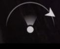
Bottom center of your screen will show you which way the drone is facing and its relationship to you. (dot with a small arc around it), triangle on the arc is the drone, triangle points the way it is facing, and you are the dot.
 
Also when I tested the return home it did come back to close to where it took off (I used a large round landing mat on the grassed surface) it landed about 500mm from the edge which could have resulted in the props touching the grass if it hadn't been recently cut. Did I do anything wrong or what is the correct procedure to lock in the start location or is this normal?

I have been flying my MA2 heavily for a few weeks now and autolanding only brought it back perfectly twice for me so far. I have mostly been flying off a very narrow dock so I manually land pretty much every time since it has tried to land on the edge or in the water too many times, missing the X by a foot or so.
 
.....autolanding only brought it back perfectly twice for me so far. ....... missing the X by a foot or so.
Very interesting especially in view of a previous reply.
Anyway I will have to remember next time to take off vertically to a height of at least 7 metres (the bottom left of screen will indicate that).

I found what I think is a good tutorial for beginners ( mavic air 2 for beginners ) and while it explains all the 'settings' it also explained a bit more about the icon bottom centre which indicates where the drone is in relation to where you are standing and it's orientation so you know which way the controls will affect it. That is great to know as starboard (green) and port (red) strobes are probably not necessary to know the orientation of the drone. I will only get a white one but maybe that too is not necessary? Please note that I have viewed lots of tutorials and thought this one quite good.
drone orientation icon.jpg
Please note that the cost of this drone really stretched my budget (I am retired) and as such I am probably over cautious to try and ensure I don't crash it or loose it. If I do then I probably would not be able to afford to replace it.
 
  • Like
Reactions: JackL and SkyeHigh
Anyway I will have to remember next time to take off vertically to a height of at least 7 metres (the bottom left of screen will indicate that).


View attachment 118835
I always let it sit on the ground after turning it on until I get > 12 gps satellites and make sure the compass triangle on the map is pointing the right way and moving correctly. I also take off vertically and hover briefly before flying away.

I could also just be paranoid and cancelling autolanding because I think it looks to tight when it would be fine. These things are not cheap!
 
  • Like
Reactions: A.O.
I take off and hover up there a few seconds just for good measure.

Bottom center of your screen will show you which way the drone is facing and its relationship to you. (dot with a small arc around it), triangle on the arc is the drone, triangle points the way it is facing, and you are the dot.
That's often been inaccurate, especially if device compass is out of calibration.

Map is always accurate, though it might not be oriented in the same direction you are.
 
Not sure though if it shows the attitude of the drone (which way it is pointing)
It does. just yaw the drone till it lines up and push the right stick forward. ..you might have to correct for drift but you'll soon see your drone.
 
however..you should be practicing flight maneuvers for awhile. You won't have any fun unless you're comfortable and that only comes with experience. I have lots of flying time and lots of ratings but I stayed in my back yard for a long time and I'm still not comfortable doing a lot of the things that people on the forum do without a second thought.
 
Whoops
I just 'revisited' compass and imu calibration and noted that they must be calibrated first time out of the box or if the drone has been transported to a different location. I did NOT do this and I never checked the top left of screen to see if they needed calibration before my maiden flight because I had forgotten AND I could not view the screen well in the bright sunlight. Something else in my list of 'must do before each flight' which I compiled and print out to take with me.

I have (re)learned/was reminded of lots with this thread and so appreciative that so many people have bothered to assist. At least I didn't crash.
 
That's often been inaccurate, especially if device compass is out of calibration.

Map is always accurate, though it might not be oriented in the same direction you are.
Whats often been inaccurate?
 
Lycus Tech Mavic Air 3 Case

DJI Drone Deals

New Threads

Members online

Forum statistics

Threads
133,803
Messages
1,587,731
Members
162,472
Latest member
DvrkDrone