DJI Mavic, Air and Mini Drones
Friendly, Helpful & Knowledgeable Community
Join Us Now

Mavic 3 - ?? Maybe Global Shutter (mechanical) ready for Mapping / Modeling possible?

Estou executando levantamento topográfico e nuvem de pontos com M3. O resultado tem sido excelente mesmo realizando vôo manual. Este ortomosaico representa uma área de 67.000m². Usei apenas uma bateria.View attachment 145822View attachment 145823
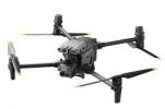
Nice work . . . yes would love it if they just let me use PILOT instead of FLY with the M3 . . . but now with M30 M30T . . there's another leap forward. . . . another game changer . . expensive but game changing for commercial, government and first responder users . . note the UP/DOWN props. I'd love to be able to map with either of them. Just waiting for a bit more spring to go exercise my M3. Best feature is the battery time
1648384480435.png
 
  • Like
Reactions: Gabriel Arcieri
easy as "google Translate" I am executing topographic survey and cloud of points with M3. The result has been excellent even when performing manual voo. This orthomosaic represents an area of 67,000m². I barely used a battery.
That should be for @Gabriel Arcieri , not me! 🤣
Not my job, or yours, to translate his foreign posts on an English only forum!
 
Nice work . . . yes would love it if they just let me use PILOT instead of FLY with the M3 . . . but now with M30 M30T . . there's another leap forward. . . . another game changer . . expensive but game changing for commercial, government and first responder users . . note the UP/DOWN props. I'd love to be able to map with either of them. Just waiting for a bit more spring to go exercise my M3. Best feature is the battery time
View attachment 145830
Other than they could mount the RTK receivers on the tail props what’s the significance of the upside down props?
 
"vôo" = flight. Don't know why Google missed that one.
Doesn't matter the language these days. I'm more interested in the information. . . but thanks for the detail. Looks like the SDK will finally get out "by Dec 23" I've heard. . . .maybe then we'll get some better use out of a really good camera.
 
Until an SDK comes out, here is a site I just found when I was searching how to manually map with a Mavic 3. Looks like it could work well! I'm definitely going to try it.

The Mavic 3 for photogrammetry - Manual Nadir Scanning

The Mavic 3 - latest and greatest DJI drone without support for flight planners yet. Learn how to fly manually for photogrammetry purposes.
www.pix-pro.com
www.pix-pro.com
 
  • Like
Reactions: GadgetGuy
Lycus Tech Mavic Air 3 Case

DJI Drone Deals

New Threads

Members online

Forum statistics

Threads
130,983
Messages
1,558,552
Members
159,972
Latest member
valter123