Hi, thanks for your reply.
Can you tell me which free tool you used to convert to TIFF?
Also, I did a flight in orthocollection with both RGB and IR camera to eventually create an orthomosaic of IR images. However, each image has a different temperature range because the camera automatically adjusts to present a "nice" result, i.e. nice colors.
Won't this cause problems with pixel matching in software like Pix4D or Agisoft? From my experience it seems like it will, because for the exact same pixel with the same temperature, the colors will be different in the 2+ images where it appears. When I tried to import my jpg in Metashape (only 3 bands, not yet converted to TIFF to have temperature info), all the images were in random places and the pixel matching was terrible.
So my second question is: is there a way to fix the temperature range so that all images from the same flight have the exact same color for the same temperature value?
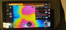
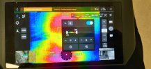
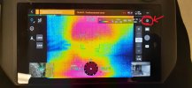
I've tried going into the thermal camera's settings to either set the range or disable "FFC auto", but it doesn't work (see attached files).
Thanks in advance!
P.S. I'm used with RGB photogrammetry in Pix4Dmapper and Mavic 3E, but I'm very new to thermal imagery.