DJI Mavic, Air and Mini Drones
Friendly, Helpful & Knowledgeable Community
Join Us Now

MAVIC FLY AWAY AND DJI CASE ANALYSES

I think most of us didn't even get to the end of the post that suggests the humoristic nature of it...
 
Hi, guys,
just checking in to tell you guys I found my drone at that building. It really crashed into the side wall and fell to the ground, on the sidewalk. A passerby found and hand it to the security.
I just had to overcome some bureaucracy but the drone is already with me.
Lost the camera and battery, some scratches, I'll try to have it repaired by DJI.
Thank you for your support and expertise.
best

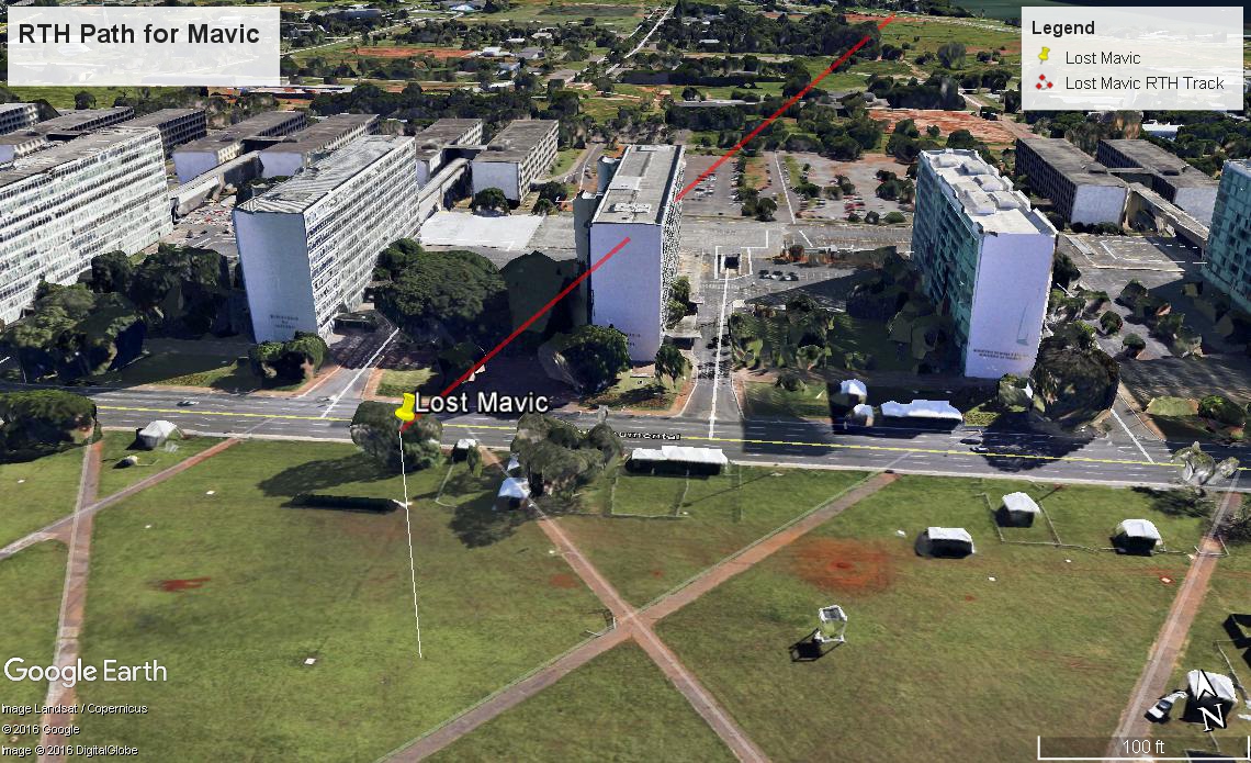
Here is a graphic that shows your Mavic and two different paths back to your location. The first picture shows the Line Of Site path between you and your Mavic. As you can see, it was blocked by the building. This is likely why you lost connectivity to your Mavic. I should also point out that you were facing a highway that was on a berm roughly 20 feet above your location- this was also blocking LOS to your Mavic to some degree.

Lost_Mavic_RTH_Track.jpg


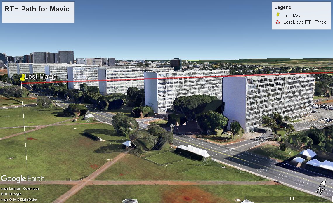
In this second picture, the actual RTH path at 103 meters is shown. As you can see, it would have barely skimmed over the top of the building, if Google Earth is accurate. It may have hit antennas or other objects on top of the building, or it may have simply hit the side of the building. It may even be on top of the building, ready to retrieve.

Lost_Mavic_RTH_Track_3.jpg
 
The most likely thing that he would hit is the mechanical room.

Fernando should pay the building manager a visit.
The most likely thing that he would hit is the mechanical room.

Fernando should pay the building manager a visit.


Hi, guys,
just checking in to tell you guys I found my drone at that building. It really crashed into the side wall and fell to the ground, on the sidewalk. A passerby found and hand it to the security.
I just had to overcome some bureaucracy but the drone is already with me.
Lost the camera and battery, some scratches, I'll try to have it repaired by DJI.
Thank you for your support and expertise.
best

Glad you recovered it!
 
Hi, guys,
just checking in to tell you guys I found my drone at that building. It really crashed into the side wall and fell to the ground, on the sidewalk. A passerby found and hand it to the security.
I just had to overcome some bureaucracy but the drone is already with me.
Lost the camera and battery, some scratches, I'll try to have it repaired by DJI.
Thank you for your support and expertise.
best

Actually I said, 90%: mech room; 9% side of the building! Glad you got it back.
 
Actually I said, 90%: mech room; 9% side of the building! Glad you got it back.
Hi, how do you find out the ground altitude of a site?
By that logic we should arrive at the same height above ground since 1113 - 1075 = 38 m. I mean you seem to believe in the 1010 m ASL for the HP, why not for the 1075 m ASL ground altitude at the building?

I did it that way because I would not trust GE over long distances for elevations. But at short ranges and relative differences in height, then you have something.

Further, there is no knowing short of getting the architects plans what the actual height of that building is.

So rendering relative to the local ground is what counts IMO. Believing the top of the building relative to sea level is accurate is really going out there with GE, notwithstanding how accurate it might be for the building rendering itself.

You also have to look at the mechanical rooms on top of the building. They are not correctly rendered. See my earlier graphic. So if "your" grazing height is correct, it would likely hit the mech rooms on the roof.

Can you help me out? how do you find out the height ASL? this is important to know before the flight...
 
Hi, how do you find out the ground altitude of a site?


Can you help me out? how do you find out the height ASL? this is important to know before the flight...

I use aviation maps (sectionals (1:500,000 and VFR Terminal Area Charts 1:250,000) though the horizontal resolution is not great. Also Google Earth, but I don't trust it for ASL at any given location. (I also have UTM maps at 1:50,000 but haven't dragged them out for drone use).

You can use your smart phone to at least use its GPS to get your take off area as well as the operations area - they won't be necessarily accurate wrt to ASL, but it will be fairly accurate 1 spot v the other. (about ±3 m for each, count ±6 m between the two).
 
  • Like
Reactions: FERNANDO
You might also consider that all of those building have various antenna on the roof. In fact, the one shown in the picture "appears" to have a large HF array. Not enough of it is visible to know for sure what it is. Any tall building is be looked at for protrusions because they are normally ideal antenna locations.
 
Yes! The conclusion(s) by the experts here have been validated!! Twist and turns and some conflicts in analysis - red lines askew here, incorrect slopes there - is it US/Brazil?? Now, after reading through the whole thread, I have to get some rest. My head is quite weary. Time to count Mavics flying over buildings...
 
Lycus Tech Mavic Air 3 Case

DJI Drone Deals

New Threads

Forum statistics

Threads
131,244
Messages
1,561,206
Members
160,193
Latest member
Pocki