

Is that the Igor Pro mentioned above? I'm looking for something where I can essentially put in the Csv and it generates a graph that I can tweak and extend. Hopefully in the future I'll have the knowledge to do more than that, but for now, that would really be nice. Thanks -CFThat question is probably best asked of @BudWalker, since he wrote the software. Personally I use the .csv files created by DatCon, imported into data analysis software, for extrapolation, integration or any other kind of numerical analysis.
You are using an out of date browser. It may not display this or other websites correctly.
You should upgrade or use an alternative browser.
You should upgrade or use an alternative browser.
Mavic Pro flew away following erratic flying, loss of control
- Thread starter JNU
- Start date
- Joined
- Oct 12, 2016
- Messages
- 30,389
- Reactions
- 34,348
- Location
- Harrisburg, PA (US)
- Site
- mavichelp.com
I'm suggesting you don't use CsvView if all you want is the CSV data.So can you just import the Csv file, highlight it, and hit the graphing button?(sorry, I have studied little on this subject yet).
Ok, say I take CsvView out of the picture, I have used DatCon to produce the Csv file, What program would I than use to create the various graphs? Does Excel accept straight Csv files or should I look into using Igor Pro like Sar104 mentioned?I'm suggesting you don't use CsvView if all you want is the CSV data.
I see. You want the .csv that's been generated so that you can import that into Excel and manipulate it. You can use the tool @msinger suggested ( this converter.) that will convert the .txt to a .csv Or, you can export it from CsvView by going to the main menu bar and selecting File->Export CsvThanks, I did figure that much out, I guess my problem is creating a graph from the info I put into Excel (not that familiar with it). I'm want to extrapolate the line past what is shown on the CsvView page so I can predict how far the AC can fly before auto landing.
So can you just import the Csv file, highlight it, and hit the graphing button?(sorry, I have studied little on this subject yet).

- Joined
- Oct 12, 2016
- Messages
- 30,389
- Reactions
- 34,348
- Location
- Harrisburg, PA (US)
- Site
- mavichelp.com
That's really up to you. There are many graphing apps that accept CSV data.What program would I than use to create the various graphs?
Ok, say I take CsvView out of the picture, I have used DatCon to produce the Csv file, What program would I than use to create the various graphs? Does Excel accept straight Csv files or should I look into using Igor Pro like Sar104 mentioned?
Yes - you can import a csv directly into Excel. And while it's not a fully fledged analysis program, it will do data extrapolation or "projecting values" as I think they call it. There are plenty of tutorials on YouTube and elsewhere on those functions.
That's really up to you. There are many graphing apps that accept CSV data.
Thanks to you both, I'll go do some research and see where I end up! Really appreciate the help! -CFYes - you can import a csv directly into Excel. And while it's not a fully fledged analysis program, it will do data extrapolation or "projecting values" as I think they call it. There are plenty of tutorials on YouTube and elsewhere on those functions.
So far I have been using CsvView to export the TXT files as CSVs, your programs are awesome and I have certainly learned a lot from them! Thanks again, -CFI see. You want the .csv that's been generated so that you can import that into Excel and manipulate it. You can use the tool @msinger suggested ( this converter.) that will convert the .txt to a .csv Or, you can export it from CsvView by going to the main menu bar and selecting File->Export Csv
Mauro Massari
New Member
- Joined
- Dec 31, 2017
- Messages
- 2
- Reactions
- 0
- Age
- 56
I am very happy about this group specially when other people help without looking for profits...... I am a reader and learn a lot just reading lots of posts.... Once again thank you for all your knowledge you are putting out and make us learn more and more and saving some drones....
Start for fly drones for more then 7 years in Brazil with the firsts DJI controllers and now I am in Australia for more then 2 year and got me a used Mavic Pro. So far so good but sometimes have a problem with video feedback, I believe is my old Samsung Note 4 and then when I restart it most of the time goes fine.... (don't want to get out directions on this post).
Keep up with your work and once more GREAT JOB......
ScubaBob
Well-Known Member
very cool ending.UPDATE
Well sar104, I am amazed. I cannot thank you enough for your prediction, as I went to this area this morning and your estimate was absolutley spot on! I walked to the exact area you suggesed at the intersection of the plotted lines and started searching, and found it at the point shown above. Your calculation was entirley correct. Thank you so much!
In terms of the drone, it was upright in the grass, intact and the only visible damage I can see is a small crack to one of the rotors, no other visible damage, just very damp. Memory card and footage also intact, I watched the footage and, as you predicted, it was drifting further and further away in the wind, for a full 15 minutes after the disconnect.
It then descended, with a lot of movement left to right as it got lower down, and completed what looks to be a very hard landing, onto snow covered grass. Was then burried in the snow for 48 hours.
It narowly missed trees and a river, by a matter of a few feet either side. I am not sure how well it was working on avoiding these at the point of critical battery landing or whether this was simply luck, but I was amazed to have found it - was truly like looking for a needle in a haystack.
My next steps now are to dry it out thoroughly and then carefully test it. I will update the thread this week with the outcome.
Really wasn't expecting to find it after 3 days searching, so thanks again for the advice, a great result today.
No feed back please. I have experienced one time a loss of control 10-15 feet off the ground at my house where I fly daily. The only thing that I noticed is we do have a green humming transformer box in out yard basically and it was between me and my MP. MP would not do anything belief me I shut off controller turned on and no connection. Only one time ever i in 62 flights but man I had to drag it out of the street. And wrestle with it while it fought me to maintain its GPS location and not get hit by the blades but hit the power button twice and hold to shut her down.. All while a guy is walking by watching this happen... At 6:30am.. Too funny.Yesterday I took my Mavic Pro on a routine flight, with a fully charged battery and a normal default RTH height of 98 ft, flying in normal mode (not sport) for the entire flight. It was 0 degrees C at the time...I fear this could be the root of all the problems I then experienced.
4 minutes into the flight, with 81% battery and at a height of 250 ft, I hit return to home.
Something very strange then happened.
The sequence of events that followed immediatley after were:
1. In RTH mode, Mavic started to climb, without any input from me.
2. I tried to counter this by pulling down on the altitude stick briefly, log shows me pulling down on stick 20%-60% for around 2 seconds. This cancelled the RTH.
3. The Mavic didn't respond and rapidly continued to climb and was also now flying away from me, backwards, with no input from me on the remote control.
4. The Mavic climbed to 311 ft on its own, and I again hit RTH, and it went into RTH mode.
5. The Mavic continued to climb with no input from me, and continued to rapidly fly further away in a straght line ascending upwards, and making big distance gains away from me.
6. I again tried to counter this by pushing the forward stick 100% on the RC, for 15 seconds. This did nothing, and the Mavic continued to fly away backwards in a straght line at around 12mph and rapidly climbing without any command, was now up to 370 ft and climbing.
7. I again hit RTH, and it went back into RTH mode.
8. In RTH mode and with no input from me on the RC, it continued to rapidly climb through 400 ft, and continuing to fly away from me backwards, totally out of control and getting further and further away.
9. Climbing through 403 ft, speeding away from me, "Battery:Overcurrent during discharge" warning was displayed. Never experienced this before.
10. Still with no input from me on the RC whatsoever, Mavic continued to fly away in a straght line, climbing, now at 420 ft and distance by this point becoming a real concern (had now reached 7,700 ft away from me, still out of control)
11. This continued a few more seconds and at a height now of 430 ft, I recieved "Motor Current Error" warning, also never experienced before. Battery at this exact moment showed 54% remaining and 4 min 30 sec remaining on the countdown bar.
12. At a height of 440 ft and climbing, and a somewhat terrifying 7900 ft away, it disconnected, and never reconnected.
This all happened over a golf course. It was unoccupied at the time, due to being covered in snow. I immediatley got in the car and drove to the area, and pulled up Find My Drone on my iPhone. On foot, I went to the exact point shown on the map, which was in the middle of a green area. No sign of the mavic anywhere.
I then spent the next 2 hours searching the area, without being able to find it. Today, I went back with two others and we searched the area extensivley again for a further 3 hours, and nothing. We tried to simulate the drone flying further away in a straght line, searching the area but no sign of it. I guess this suggests the flight continued for some time on its own accord following disconnect and went further away. There are woods either side of the area, so likely it could be in there somewhere and that is literally like trying to find a needle in a haystack.
I will try and upload the flight logs, but upon first glance has anybody ever experienced this complete loss of control and does anybody have any idea as to why this may have happened?
I will contact DJI care about this, and will update this thread with their response when I get it. I'm looking at a claim on my home insurance for this, but in the meantime would love to hear if anyone has experienced similar issues as this was pretty scary, and has sadly resulted in a complete loss.
Thanks all in advance
Justin
That’s the funniest thing I have read in a long time...I guess because I am feeling the same way. Haha!Every morning I wake up feeling smart ~until I see stuff like this. And @msinger ~not too shabby, either. I'm going to go throw some poo on the wall now.
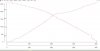
Well I got Igor Pro and man is it some software! It took me a couple days to figure out what I wanted to do (I'm sure it isn't as accurate as it could be) but here is what I came up with.Yes - you can import a csv directly into Excel. And while it's not a fully fledged analysis program, it will do data extrapolation or "projecting values" as I think they call it. There are plenty of tutorials on YouTube and elsewhere on those functions.
I'm a couple hundred meters off from yours (I think it has something to do with my extrapolated distance line) but I'm pretty happy! Thanks for mentioning what you used as it was exactly what I was looking for! Here is the location I came up with

Thanks again and this program is awesome! -CF
Attachments
Now you have to step up to the plate and help out when @sar104,@BudWalker and @msinger are too busy helping out others find their birds!Well I got Igor Pro and man is it some software! It took me a couple days to figure out what I wanted to do (I'm sure it isn't as accurate as it could be) but here is what I came up with. View attachment 33559
I'm a couple hundred meters off from yours (I think it has something to do with my extrapolated distance line) but I'm pretty happy! Thanks for mentioning what you used as it was exactly what I was looking for! Here is the location I came up with View attachment 33560
Thanks again and this program is awesome! -CF
That's a little intimidating don't you think?Now you have to step up to the plate and help out when @sar104,@BudWalker and @msinger are too busy helping out others find their birds!

Well I got Igor Pro and man is it some software! It took me a couple days to figure out what I wanted to do (I'm sure it isn't as accurate as it could be) but here is what I came up with. View attachment 33559
I'm a couple hundred meters off from yours (I think it has something to do with my extrapolated distance line) but I'm pretty happy! Thanks for mentioning what you used as it was exactly what I was looking for! Here is the location I came up with View attachment 33560
Thanks again and this program is awesome! -CF
The distance difference is mainly because you fitted a second order polynomial to the battery depletion rate, whereas I used a linear fit to the depletion rate once it was at altitude. One of those situations where more advanced is not necessarily better. Also, of course, there was a significant element of luck in my estimate being so close to the actual location.
I'm glad to hear you like the program - it is extremely powerful, especially with the compiled, user-defined functions.
Yeah, I'm sure I've only scratched the surface of what it is capable of and it will take me a while to make everything smoother and more accurate. I really know very little of what I'm doing, but fortunately Igor is smart enough to make up for any lapse in my knowledge.The distance difference is mainly because you fitted a second order polynomial to the battery depletion rate, whereas I used a linear fit to the depletion rate once it was at altitude. One of those situations where more advanced is not necessarily better. Also, of course, there was a significant element of luck in my estimate being so close to the actual location.
I'm glad to hear you like the program - it is extremely powerful, especially with the compiled, user-defined functions.
") -CF
-CFFranzinator
Well-Known Member
- Joined
- Apr 28, 2017
- Messages
- 91
- Reactions
- 32
- Age
- 55
@sar104 amazing work! You guys are good
Thank you. There's no doubt that I got a little lucky on this one, but the method seems to be fundamentally sound.
Similar threads
- Replies
- 2
- Views
- 1K
- Replies
- 4
- Views
- 441
- Replies
- 2
- Views
- 657
- Replies
- 11
- Views
- 2K


DJI Drone Deals
New Threads
-
3 A Cyclone is about to hit Darwin, do we stay or go?
- Started by Vernon
- Replies: 0
-
-
-

Members online
Total: 3,941 (members: 10, guests: 3,931)
Forum statistics
