DJI Mavic, Air and Mini Drones
Friendly, Helpful & Knowledgeable Community
Join Us Now

Mavic Pro Lost going to wrong Home

jookieapc

Member
Joined
Dec 15, 2018
Messages
9
Reactions
2
Hi Mav Pilots

After an extended time out of action, I finally replaced a broken prop arm and reassembled the Mavic Pro. It was flying well too but my rustyness was apparent in losing the drone yesterday afternoon.

I went into Sport Mode and travelled through a nice scenic view. I wasn't paying attention to the drone's battery as I should have. I also didn't notice there was no GPS coverage when I first took off, so the drone didn't have a valid home location.

The battery hit 20% and prompted me to return home
Low power. Returning home.

I did not delay, selecting to let it do the work and come back in a battery efficient way (another mistake on my part). It flew back slowly, and flew to a random location beside a busy road and was not happy to land.

At 13% battery it said
AutoLandingCritically low power. Aircraft is landing.

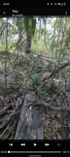
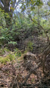
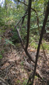
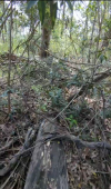
When I realised it was lost at about 10% battery and I was in trouble. I saw power lines above, the road with cars, trees and high trees. I ascended, and reversed out of the trapped area (while in sport mode?) I think. Although the logs do say it was in Return to Home mode. Somehow, I ascended from around 2 metres alt in the sonar sensor, up to around 20 metres alt baro. I flew forward then, but I was still too low. Looking at the GPS location and reconstructing things, it appears I flew toward a tall, large tree and hit it. I have used Find my Drone, but the location it takes me to is the large tree. I've searched the area all around the drone which is thick vegetation with no luck. I searched for 2 hours last night and around 5 hours today.

I'm find the GPS position on my phone bounces around a lot from the tree cover or from a nearby pole mounted transformer.

Do you have any recovery tips or advice for me? Would my drone still be in sport mode, if I had selected return to home?

Foolishly, because it's been about 2 years since I regularly flew my Mavic Pro on my old phone, my new phone's app wasn't set up right. It was set to 2G local storage only. So on the trip of 15 minutes, it only recored about the first 5 minutes and not the critical last 30 seconds. If I only I could get that it would help! Are there any tricky locations where the DJI4 app might save the last video footage?

When my drone got stuck, it seemed like it was at 18m altitude, in the tree maybe? I could see in the video feed as I rushed toward it, that it appeared to be in a tree. As I got closer the video feed went to black and white just as I lost all contact with it.

1639747811853.png

The final location say it was 17.7m above the takeoff height. When I lost contact with the drone it was stable somewhere, with the motor stuck.

I'm thinking to return to the site with another loan drone and try to travel to the same location and check up in the tree better.

*sigh*.

jookieapc
 
  • Wow
Reactions: Rchawks
Hi there & welcome to the forum ... even though it's under these circumstances.

... I also didn't notice there was no GPS coverage when I first took off, so the drone didn't have a valid home location.
Your drone wasn't on it's way to the "wrong Home" ... it was on it's way to where the GPS data for the first time became sufficient for recording a home point, and that was somewhere along the flight path you flew your drone.

The battery hit 20% and prompted me to return home...selecting to let it do the work and come back

At 13% battery it said...AutoLanding...Critically low power. Aircraft is landing.

Would my drone still be in sport mode, if I had selected return to home?
No ... when you confirmed the lowbattery RTH it went from Sport to RTH ... & then later when the battery percentage hit the lowbattery force auto land threshold it would have been in landing mode (both RTH & landing have the same specs as normal mode). Once the force landing have started you can't cancel it... you can arrest the descending by applying throttle for ascending but as soon as you release the stick to neutral it will descend again. During this it's possible to maneuver the drone horizontally.

...Are there any tricky locations where the DJI4 app might save the last video footage?
Unfortunately no ...

Do you have any recovery tips or advice for me?
I'm thinking to return to the site with another loan drone and try to travel to the same location and check up in the tree better.
As you propose ... check off that tree thoroughly.
 
Up load the flight log to DJI Flight Log Viewer | Phantom Help then expand the ariel view to maximum and work out where the location is in the real world then go to that location with or without the aid of gps on your phone.
Alternatively do a www search for the last latitude and longitude then look at ariel view of that location in the likes of google maps or bing maps.
 
  • Like
Reactions: jookieapc
Upload the log so we can check it! That would help a lot.
 
  • Like
Reactions: jookieapc
I went into Sport Mode and travelled through a nice scenic view. I wasn't paying attention to the drone's battery as I should have. I also didn't notice there was no GPS coverage when I first took off, so the drone didn't have a valid home location.
Your drone records a home point when it first gets good GPS location data.
As you launched without waiting for good GPS, the homepoint will be somewhere on your outward flight path.
Do you have any recovery tips or advice for me?
Post your flight data and someone will be able to confirm the landing location from that.
Go to DJI Flight Log Viewer | Phantom Help
Follow the instructions there to upload your flight record from your phone or tablet.
That will give you a detailed report of the flight.
Come back and post a link to the report it gives you.
Or .. just post the txt file here.
 
So sorry for your loss. Hope you are able to recover it.
 
  • Love
Reactions: jookieapc
Your drone records a home point when it first gets good GPS location data.
As you launched without waiting for good GPS, the homepoint will be somewhere on your outward flight path.

Post your flight data and someone will be able to confirm the landing location from that.
Go to DJI Flight Log Viewer | Phantom Help
Follow the instructions there to upload your flight record from your phone or tablet.
That will give you a detailed report of the flight.
Come back and post a link to the report it gives you.
Or .. just post the txt file here.

Ok thank you and to everyone else for the helpful responses and offers to help. I opened the KML of the flight in Google Earth using AirData export and it's incredible to see the 3d perspective of the flight. It's giving me another location I'm thinking to check out now.

Above is a link to the flight on phantomhelp and also the DJI text file is attached. (BTW, isn't it weird to call it a text file when it's all encrypted and not text like?)

Can you try to answer a couple of questions that should be helpful in the search.

  1. Did the drone land, or was it stuck in a tree?
  2. Is there any sign of the drone using obstacle avoidance in the final path?
  3. Did it land in the bush or by the side of the road?

I'm going to search again tomorrow with my cousin and his Mini 2.
 

Attachments

  • DJIFlightRecord_2021-12-16_[19-20-19].txt
    1.2 MB · Views: 12
  • Like
Reactions: toadmeister2k
  1. Did the drone land, or was it stuck in a tree?
  2. Is there any sign of the drone using obstacle avoidance in the final path?
  3. Did it land in the bush or by the side of the road?
You launched before the drone had GPS data.
It wasn't until 59 seconds into the flight that the drone got god GPS data and recorded it's homepoint where it was at the time.
That was at -33.53069 151.20121.
Low Battery Autolanding (from 400 ft) commenced at 12:09.3.
The pitch, rol and yaw data suggests that the deone gently touched tree branches at about 13:10.1 and bounced around a little as it came down from there, landing about 8 metres further down.

The drone descended gradually and came to rest in a level position, indicating that it landed on the ground rather than crashing or getting stuck in a tree.
The indicated height in the data is -1.5 metres, but because of the drift that's commonly seem in altitude readiings this may not be accurate.

The location of the landing was -33.52998 151.20118.

Obstacle avoidance isn't active during landing.
 
  • Like
Reactions: jookieapc
  1. Did it land in the bush or by the side of the road?
Here's a rough location out east of the road where the drone came down
i-m46JM4Q-L.jpg
 
...The pitch, rol and yaw data suggests that the deone gently touched tree branches at about 13:10.1 and bounced around a little as it came down from there, landing about 8 metres further down.
Suspect that you've mixed up some flight logs you where working with at the same time..?

When the craft makes contact with the tree the craft pitched from about -22 degrees up to nearly +62 & then down to -57 degrees. At the same time it rolled from about 0 degrees over to the left with 47 degrees then to the right with 119 degrees, the crash continued during a 7sec period ... all consistent with a craft plowing through a tree. The height difference between when it hit the tree for the first time & when it came to rest is only 3m down.

The drone descended gradually and came to rest in a level position, indicating that it landed on the ground rather than crashing or getting stuck in a tree.
The indicated height in the data is -1.5 metres, but because of the drift that's commonly seem in altitude readiings this may not be accurate.
When the log ends the craft pitches down 18 degrees & is rolled over to the left side with 61 degrees. The height there is 17,7m above the point where the craft was reported to be airborne. In the sat pic further below the green path is where the mobile device was located & that was presumably the take-off spot (... not at the yellow star where the HP later got recorded). The height difference between the presumed launch spot & where the craft ended up is about the same (differs only a couple meters with the crash location slightly higher) ... so with a craft position (pitch & roll) & on approx 14m height above ground beneath, the craft most likely is stuck up in the tree.

1639914362012.png

1639914975730.png

The location...was -33.52998 151.20118.
Yep ... that position matches this incident ...
 
Suspect that you've mixed up some flight logs you where working with at the same time..?
That's weird ... I've reloaded the same spreadsheet file and it's showing different numbers for some things.
Same location data, same time for the initial collision with the tree, but different numbers for height, VPS and pitch/roll on the way down.

I'm not sure what the explanation is.
 
Last edited:
Your drone records a home point when it first gets good GPS location data.
As you launched without waiting for good GPS, the homepoint will be somewhere on your outward flight path.

Post your flight data and someone will be able to confirm the landing location from that.
Go to DJI Flight Log Viewer | Phantom Help
Follow the instructions there to upload your flight record from your phone or tablet.
That will give you a detailed report of the flight.
Come back and post a link to the report it gives you.
Or .. just post the txt file here.
I thought I had posted my reply yesterday but it was sitting as a draft. Thank you for the speedy response.

Can you help me understand a bit more about your altitude analysis? I tried to determine the land height above sea level around the crash site but I'm lost. The last altitude measure was around 17m so I was looking up in trees!

The vegetation is very thick there. I have trampled and chopped the lantana around the lat long of the area.

Suspect that you've mixed up some flight logs you where working with at the same time..?

When the craft makes contact with the tree the craft pitched from about -22 degrees up to nearly +62 & then down to -57 degrees. At the same time it rolled from about 0 degrees over to the left with 47 degrees then to the right with 119 degrees, the crash continued during a 7sec period ... all consistent with a craft plowing through a tree. The height difference between when it hit the tree for the first time & when it came to rest is only 3m down.


When the log ends the craft pitches down 18 degrees & is rolled over to the left side with 61 degrees. The height there is 17,7m above the point where the craft was reported to be airborne. In the sat pic further below the green path is where the mobile device was located & that was presumably the take-off spot (... not at the yellow star where the HP later got recorded). The height difference between the presumed launch spot & where the craft ended up is about the same (differs only a couple meters with the crash location slightly higher) ... so with a craft position (pitch & roll) & on approx 14m height above ground beneath, the craft most likely is stuck up in the tree.

View attachment 140396

View attachment 140397


Yep ... that position matches this incident ...
What does the yellow icon indicate? <<the HP (HOME POINT) >>

You're correct about the launch site. That is in an elevated car park area. The yellow mark is at the same level as the Pacific Hiway which is about 4 metres lower than the car park.

As I had a video feed from when the drone was stuck, I had the impression that the drone was trapped in a tree at that point. It continued to give me a video feed for sometime in the stuck position with motor stuck errors for around 30 seconds or so before the feed went to grey scale and faded out.

I really wish my drone had a separate back up battery with a location beacon and I was more cautious with flying again after being off the controls for so long.
 

Attachments

  • Screenshot_20211219-234239.png
    Screenshot_20211219-234239.png
    2.8 MB · Views: 27
  • Screenshot_20211219-234254.png
    Screenshot_20211219-234254.png
    3.3 MB · Views: 26
  • Screenshot_20211219-234327~2.png
    Screenshot_20211219-234327~2.png
    3 MB · Views: 26
  • Screenshot_20211219-234239~2.png
    Screenshot_20211219-234239~2.png
    2.7 MB · Views: 26
Last edited:
Can you help me understand a bit more about your altitude analysis? I tried to determine the land height above sea level around the crash site but I'm lost. The last altitude measure was around 17m so I was looking up in trees!
The altitude numbers I was looking at appear to have been incorrect.
The numbers Slup gave are correct.
Remember the height is not necessarily correct.
It is a height relative to the launch point, not where the drone is.
And barometric altitude data is subject to drifting during the time of a flight.
The drift might might be +/- 6 metres or so.
The vegetation is very thick there. I have trampled and chopped the lantana around the lat long of the area.
You could be within a metre of a grey Mavic in lantana and still not see it.
 
  • Like
Reactions: jookieapc
The altitude numbers I was looking at appear to have been incorrect.
The numbers Slup gave are correct.
Remember the height is not necessarily correct.
It is a height relative to the launch point, not where the drone is.
And barometric altitude data is subject to drifting during the time of a flight.
The drift might might be +/- 6 metres or so.

You could be within a metre of a grey Mavic in lantana and still not see it.
Yep!! Plus there are multiple levels to check too.

Leading up to the crash there's a sonar reading of an object below of 5.6m. I'm assuming that was when the drone was flying about 5 metres above some trees/shrubs. The lat long where the drone is mostly stationary at the end is all around the north western side of the largest tree in the area which around 20m high.
 
These drones are very good at hiding in trees unless you get there in time to use the find me function and, if applicable, can make the lights flash etc. I tree'd a Mavic Mini in a low tree and it turns out I was within an arms length of the drone and I couldn't see it. Fortunately the camera was still alive and I could recognise what the drone was seeing, I put the end of a brush shaft in shot and moved it back closer to the camera. It turned out that the MM was in a branch fork at arm's length over head.
You perhaps have an advantage in that the MP is bigger than the MM.
Using a screen recorder on the phone is a good idea, it would have captured the last image seen by the camera.
Good luck with your hunt.
Also placing some smaller reflective stickers on various places, top & bottom of the craft can be an effective way to find it higher up in trees ... just wait until it get dark & use a flashlight, the craft, if it's there, will reveal it's position within seconds 😁
 
I have just noticed the height in the early part of the flight, I can think of at least 3 other "can you help find my drone" threads where similar heights are involved.
Coincidence?
 
These drones are very good at hiding in trees unless you get there in time to use the find me function and, if applicable, can make the lights flash etc. I tree'd a Mavic Mini in a low tree and it turns out I was within an arms length of the drone and I couldn't see it. Fortunately the camera was still alive and I could recognise what the drone was seeing, I put the end of a brush shaft in shot and moved it back closer to the camera. It turned out that the MM was in a branch fork at arm's length over head.
You perhaps have an advantage in that the MP is bigger than the MM.
Using a screen recorder on the phone is a good idea, it would have captured the last image seen by the camera.
Good luck with your hunt.
That's the other annoying part. When I previously was flying on a previous phone, I had the local video cache turned right up to record more video feed. That's why I don't have the video feed of the last moments but only have a very very rough recollection of what I could see on the video feed as I was rushing down to rescue my drone when battery was down to 1%.

I'd much rather the video cache on the phone to work like a crash cam, i.e. It always retains the last 10 minutes of video, rather than simply stopping recording once it hit 2 gigabytes. Is it possible through the settings for it to delete older footage and always have the latest available?
 
I have just noticed the height in the early part of the flight, I can think of at least 3 other "can you help find my drone" threads where similar heights are involved.
Coincidence?
What are you suggesting the connection is Philius? That height is high risk for crashing/getting stuck in trees?
 
Last edited:
I am wondering if there is a connection between the way the drone is flown and the risk of it's being lost through the battery being drained or whatever.
 
Lycus Tech Mavic Air 3 Case

DJI Drone Deals

New Threads

Forum statistics

Threads
130,411
Messages
1,552,346
Members
159,418
Latest member
jamoke