DJI Mavic, Air and Mini Drones
Friendly, Helpful & Knowledgeable Community
Join Us Now

Mini 3 Pro "flyaway" Lost control!

GILLYuk

Member
Joined
May 3, 2023
Messages
8
Reactions
14
Age
40
Location
Dorset, UK
Hey, this is my first post and sadly not a good one!

I was out flying my mini 3 pro close to my home at the weekend over the sea, I had been trying to grab some pics and footage of jet ski's visiting the area. The conditions were good and at the time of the incident I was trying to compose a shot of the riders who were stationary about 10 metres or so in front with no other obstacles in range. All of a sudden the screen showed my drone/gimbal moving erratically as though it was tumbling from height, like nothing I have seen before with the mini 3 pro or my mavic pro! At this point I lost all control and then shortly after the signal. There is no chance of getting the drone back unless it one day washes up on the shore!

I have been flying for a few years without any problems so never had to look at the logs until now. I'm hoping you guys can help me work out what went wrong! I have spoken with a couple of guys at DJI, one has said I hit an obstacle and then received the error messages once it landed in the water... The next guy said the obstacle I hit was the water?!


Any help is appreciated, cheers
 
Last edited:
  • Like
Reactions: f13dfx
I have spoken with a couple of guys at DJI, one has said I hit an obstacle and then received the error messages once it landed in the water... The next guy said the obstacle I hit was the water?!
Did the DJI support people see and analyse the data to come to those conclusions?
What they say is the common explanation for drones coming to grief flying low over water, but it's hard to see this confirmed in your data.
A number of things don't make this incident look like a typical drone flown into the water or a wave coming up to catch the drone.

When things started to go bad, how far above the water do you think the drone was?
How high were the waves .. or how flat was the water surface?
Do you have cached video from the controller?

I'm looking at the recorded data and there is a difficulty with the height data that makes it hard to be sure how far the drone was above the water.

It's common for the barometric sensor that's the primary height sensor, to drift over the duration of a flight so that the height indication at the end of a flight could be easily +/- 10 feet or more from the true value.
The secondary, short range infrared height sensor is more precise and reliable, but on the day, it wasn't getting good readings from the water's surface.

The first sign of trouble that shows in the data comes at 13:02.0 when you gave a little left rudder to rotate the drone anti-clockwise.
But instead of rotating anticlockwise, the drone started rotating in a clockwise direction.
At 13:02.2 the data shows the drone which had been hovering, flying forward at erratic speed, with no corresponding right stick input.

At 13:02.8 after you released the rudder, the drone started to rotate anticlockwise with no rudder input.
The pitch and roll data suggest the drone is flying forward as it's rotating and at one point shows an extreme pitch value of -47.5°.

At 13:03.3 you gave full left stick up to climb away from trouble.
The barometric sensor shows the drone only gaining 2 ft of height, in the next second before falling back 4 feet before the data ends.

Two IMU error messages start to appear from 13:02.2:
AGyroscope initialization failed. Restart aircraft (Code: 16020004).; Sensor error. Restart aircraft (Code: 1610004A).; Navigation system error.​
IMU hardware malfunction. Repairs required. Contact DJI Support for assistance (Code: 16100005).; AGyroscope initialization failed. Restart aircraft (Code: 16020004).; Gyroscope initialization failed. Restart aircraft (Code: 30045).; Sensor error. Restart aircraft (Code: 1602000D, 1610004A).​

This is as the drone was spinning and just before you gave it left stick up.
If the drone was well clear of the water/waves, this suggests a genuine hardware error caused the incident.
The difficulty in the data is telling the actual distance above the water when this happened.
I appreciate the detailed reply! When it happened, I was easily a few metres above the water. The water was relatively flat as it was a calm day. I also took off 3 or more metres above sea level if that makes any difference. Sadly I dont see any saved video on the handset which I know would help my case!

The guys at DJI didnt even mention the errors so I'm not sure what they see from the logs their end, I would assume it was the same the data here! This is the reply I got from them:


Hello,

thank you for your patience.

I have just recieved the result of your data analysis.

  • The aircraft worked under the GPS mode, and responded well to the pilot's command;
  • Flight Time T=13:01, Relative Height H=2.2 m, Distance to Home Point D=873.5 m, the pilot moved the yaw stick to the left, the aircraft rotated leftward and crashed with obstacles;
  • The incident coordinate: 50.7057486, -2.7629058.

Conclusion: There was no technical malfunction of the drone.
 
When it happened, I was easily a few metres above the water. The water was relatively flat as it was a calm day.
This is the important point.
DJI and I have no way to tell how high the drone was above the water.
The drone was too far away to see so you would only have the screen view to judge this.
The wideangle lens of the drone makes things appear further away than they are.
This makes flying close to the water surface risky, particularly when the water level can rise or fall as it does at sea.
I also took off 3 or more metres above sea level if that makes any difference.
It doesn't and is what I assumed looking at where you flew from.
The guys at DJI didnt even mention the errors so I'm not sure what they see from the logs their end, I would assume it was the same the data here!
They would have looked at the same data.

  • The aircraft worked under the GPS mode, and responded well to the pilot's command;
  • Flight Time T=13:01, Relative Height H=2.2 m, Distance to Home Point D=873.5 m, the pilot moved the yaw stick to the left, the aircraft rotated leftward and crashed with obstacles;
  • The incident coordinate: 50.7057486, -2.7629058.

Conclusion: There was no technical malfunction of the drone.
Here are my thoughts.
Where I've used bold type, it's paraphrasing DJI's comments

The aircraft worked under the GPS mode, and responded well to the pilot's command
This is correct

Flight Time T=13:01, Relative Height H=2.2 m, Distance to Home Point D=873.5 m, the pilot moved the yaw stick to the left, the aircraft rotated leftward and crashed with obstacles;

At 13:01.8, while hovering at an indicated relative height of 2.2 metres above the launch point....
As explained earlier we cannot be sure from the data whether the drone was 6 inches or 16 feet above the water.
The lack of VPS altitude data for the whole of the flight while the drone was over water makes this impossible.

.... you gave the drone a little left yaw to rotate the drone anticlockwise.
When a hovering drone rotates, it's not usual for for it to collide with anything.

Out on open water, the only way to collide with something would be for the drone to be low enough to be hit by a wave.
What did it collide with?
The data doesn't show the usual pitch, roll and yaw data that would indicate a collision.

What caused the horizontal flight (with no corresponding joystick input) seen from 13:02.2?
After 13:02.2 the data shows erratic behaviour by the drone accompanied by IMU error messages.
We cannot rely on the height data to tell how high the drone was above water, but it should be a reliable indication of whether the drone was rising or falling.

I can't tell if you were so close to the water that a small wave could have just caught the drone enough to fry some circuits with salt water and cause erratic behaviour ...
Or if the drone was hovering 10 feet above the water, suffered IMU fault that caused erratic behaviour.

I wish it was more clear cut as it would be if there was VPS data to give certainty of teh height above the water.
Perhaps @slup might have some additional insight?
 
...Perhaps @slup might have some additional insight?
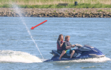
Well... I don't see anything more than you in the logs, but I can imagine a scenario based on what the OP writes below.

... footage of jet ski's visiting the area. ...I was trying to compose a shot of the riders who were stationary about 10 metres or so in front...
Were these guys with the jet skis your buddies or just some unknown & did you have all of them in front of you or was it somebody behind you?

Here in Sweden jet skis are a plague during summer, going close to other boats & bathing people, stirring up the water around people canoeing & just acting like real dumb a$$es.

One scenario that could have caused this, as you were close to the surface & close up to them... either by mistake or they aimed to take your drone down.

1683189919138.png
 
One of my favorite things is to fly over the water as long as I can as low as i can and the problem with 3 ft is that over time the drone lowers on it own, most likely you just hit the water.

If you want to get low to the water you have to start at a reference point close to you so you can see the drone exact height , than as you go across the water after about 100 ft you have to slowly gain altitude as slow as you can , thus the further you go the more your drone has gained height.

Each drone has its own starting point as to how low I can start the flight from, the key is to start as low as possible and than through out the entire flight after about 100 ft gently raise the alt . Each time you start and stop over the water there is a chance your going lower.

It is very difficult to lower you drone from far away over the water and than try to suspend that height.
you really have to have a Reference point first. This may mean that each take you have to come back to the starting point where you can see how high your drone really is from the water, and go again.


Phantomrain.org
Gear to Fly in the Rain. Land on the Water, and fly very low over the breakers.
 
This is the important point.
DJI and I have no way to tell how high the drone was above the water.
The drone was too far away to see so you would only have the screen view to judge this.
The wideangle lens of the drone makes things appear further away than they are.
This makes flying close to the water surface risky, particularly when the water level can rise or fall as it does at sea.

It doesn't and is what I assumed looking at where you flew from.

They would have looked at the same data.


Here are my thoughts.
Where I've used bold type, it's paraphrasing DJI's comments

The aircraft worked under the GPS mode, and responded well to the pilot's command
This is correct

Flight Time T=13:01, Relative Height H=2.2 m, Distance to Home Point D=873.5 m, the pilot moved the yaw stick to the left, the aircraft rotated leftward and crashed with obstacles;

At 13:01.8, while hovering at an indicated relative height of 2.2 metres above the launch point....
As explained earlier we cannot be sure from the data whether the drone was 6 inches or 16 feet above the water.
The lack of VPS altitude data for the whole of the flight while the drone was over water makes this impossible.

.... you gave the drone a little left yaw to rotate the drone anticlockwise.
When a hovering drone rotates, it's not usual for for it to collide with anything.

Out on open water, the only way to collide with something would be for the drone to be low enough to be hit by a wave.
What did it collide with?
The data doesn't show the usual pitch, roll and yaw data that would indicate a collision.

What caused the horizontal flight (with no corresponding joystick input) seen from 13:02.2?
After 13:02.2 the data shows erratic behaviour by the drone accompanied by IMU error messages.
We cannot rely on the height data to tell how high the drone was above water, but it should be a reliable indication of whether the drone was rising or falling.

I can't tell if you were so close to the water that a small wave could have just caught the drone enough to fry some circuits with salt water and cause erratic behaviour ...
Or if the drone was hovering 10 feet above the water, suffered IMU fault that caused erratic behaviour.

I wish it was more clear cut as it would be if there was VPS data to give certainty of teh height above the water.
Perhaps @slup might have some additional insight?

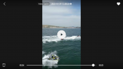
So I have fired up the controller and there is a chached video in the aircraft album. It doesn't show when the crash happened, it only shows when i shot a short video of the jet ski's heading to the the crash site. But if i have looked at the data correctly, it shows how high the drone would have been when it crashed at 6.2ft. The problem I have now is there is no option to download or share from the controller, any ideas?

Screenshot_20230504-193622.png
 
Last edited:
Well... I don't see anything more than you in the logs, but I can imagine a scenario based on what the OP writes below.


Were these guys with the jet skis your buddies or just some unknown & did you have all of them in front of you or was it somebody behind you?

Here in Sweden jet skis are a plague during summer, going close to other boats & bathing people, stirring up the water around people canoeing & just acting like real dumb a$$es.

One scenario that could have caused this, as you were close to the surface & close up to them... either by mistake or they aimed to take your drone down.

View attachment 163646

So it was a race event that happens here once a year. The organisers are always happy with us taking the drones up. We liaise with them so we know who is where with their drones. At the time of the crash I was the only one up and all of the riders(jet ski's) were in front and in my frame. They had been stationary for a short while as this was before the race and thankfully their jet ski's do not shoot water up like that.
 
So I have fired up the controller and there is a chached video in the aircraft album. It doesn't show when the crash happened, it only shows when i shot a short video of the jet ski's heading to the the crash site. But if i have looked at the data correctly, it shows how high the drone would have been when it crashed at 6.2ft. The problem I have now is there is no option to download or share from the controller, any ideas?

View attachment 163671
I recognise that place, Westbay, Your drone is a long way out, problem with that is you can't see what happend to it. Always risky flying BVLOS. Hope someone can shed light on why it ended in the sea. Good luck.
 
I recognise that place, Westbay, Your drone is a long way out, problem with that is you can't see what happend to it. Always risky flying BVLOS. Hope someone can shed light on why it ended in the sea. Good luck.
Yeah, it's further away then I had planned to be, but the conditions were good and I had no problems with signal. I was also in comms with another pilot who was situated much closer on the east pier who could see my drone, but 1 second it's there, the next it's gone, hence the post and wanting to see if there was anything obvious. Cheers
 
One of my favorite things is to fly over the water as long as I can as low as i can and the problem with 3 ft is that over time the drone lowers on it own, most likely you just hit the water.

If you want to get low to the water you have to start at a reference point close to you so you can see the drone exact height , than as you go across the water after about 100 ft you have to slowly gain altitude as slow as you can , thus the further you go the more your drone has gained height.

Each drone has its own starting point as to how low I can start the flight from, the key is to start as low as possible and than through out the entire flight after about 100 ft gently raise the alt . Each time you start and stop over the water there is a chance your going lower.

It is very difficult to lower you drone from far away over the water and than try to suspend that height.
you really have to have a Reference point first. This may mean that each take you have to come back to the starting point where you can see how high your drone really is from the water, and go again.


Phantomrain.org
Gear to Fly in the Rain. Land on the Water, and fly very low over the breakers.
My Phantomrain A2 Rescue Jacket has been great since it’s usually over water. Less pucker factor, never needed but great insurance. My old Mini 1 liked to descend over water, especially under 15’ above surface..hover or moving. A2 not so much, some just got personalities. I figure don’t fly close to water without planning for a wet landing. Jacket may have helped OP this time, hard to tell but recovery would be assured.
PS: is mini 2 Rescue Jacket compatible mini 3?

Thanks again, my suit and jacket still fit and look good too.
 
Yeah, it's further away then I had planned to be, but the conditions were good and I had no problems with signal. I was also in comms with another pilot who was situated much closer on the east pier who could see my drone, but 1 second it's there, the next it's gone, hence the post and wanting to see if there was anything obvious. Cheers
I don't know how long you have been droning ? I've always been nervous about losing my drone due to the cost of a replacement. When I started back in 2017 with a Mavic Pro, there were youtube video's of flying in cities, NY etc, as the years have passed more and more regulations have been introduced. I sold a Mavic 2 pro, and bought a Mini 2, then a Mini 3 pro due to the reduced restrictions of a <250g drone. Its a great freedom with just a a few key restrictions, No flying in a NFZ, No flying over crowds, and the real frustrating one VLOS, Visual Line of Sight, VLOS has just been tightened in the UK to meaning being able to see the orentation of the drone by sight. These rules are nothing to do with protecting me from losing my drone (although it helps) its because we can only see a narrow view on the screen and not 360° of where our drone is and hence maybe not a paraglider, an air ambulance, police helicopter, all that can fly within 120m altitude anywhere.

The gulls of West Bay are ruthless, stealing food, ice cream of the cone, and just maybe attacking drones.

You may have to accept the loss of this drone, but don't let it deter you from getting another, just respect you need to be careful.

You could post on the DJI forum for further analysis of the flight data under the Mini 3 pro category. If you do I won't be passing any further comments. All the best and good luck if DJI reimbuse you.
 
But if i have looked at the data correctly, it shows how high the drone would have been when it crashed at 6.2ft.
The data has no accurate indication of how high the drone was above the water.
The height you see on screen is relative to the launch point, but its accuracy drifts aver the duration of a flight due to changes in air pressure.
The VPS height recorded in the data would be quite accurate if it was working, but unfortunately it only worked during the first few seconds of flight before the drone reached the water.
Flying low over water is fine if you have he option of pushing up if you see it losing height, if your flying blind ? Accept you may lose your drone / money.
 
The data has no accurate indication of how high the drone was above the water.
The height you see on screen is relative to the launch point, but its accuracy drifts aver the duration of a flight due to changes in air pressure.
The VPS height recorded in the data would be quite accurate if it was working, but unfortunately it only worked during the first few seconds of flight before the drone reached the water.
Oh, I meant the video gives an idea of my height at my lowest point which would have been well out of reach of a wave and the riders. Just unsure how to download the video.
 
I don't know how long you have been droning ? I've always been nervous about losing my drone due to the cost of a replacement. When I started back in 2017 with a Mavic Pro, there were youtube video's of flying in cities, NY etc, as the years have passed more and more regulations have been introduced. I sold a Mavic 2 pro, and bought a Mini 2, then a Mini 3 pro due to the reduced restrictions of a <250g drone. Its a great freedom with just a a few key restrictions, No flying in a NFZ, No flying over crowds, and the real frustrating one VLOS, Visual Line of Sight, VLOS has just been tightened in the UK to meaning being able to see the orentation of the drone by sight. These rules are nothing to do with protecting me from losing my drone (although it helps) its because we can only see a narrow view on the screen and not 360° of where our drone is and hence maybe not a paraglider, an air ambulance, police helicopter, all that can fly within 120m altitude anywhere.

The gulls of West Bay are ruthless, stealing food, ice cream of the cone, and just maybe attacking drones.

You may have to accept the loss of this drone, but don't let it deter you from getting another, just respect you need to be careful.

You could post on the DJI forum for further analysis of the flight data under the Mini 3 pro category. If you do I won't be passing any further comments. All the best and good luck if DJI reimbuse you.
I have been flying roughly 4/5 years with a mavic pro and last year bought the mini 3 pro, I use a drone most days when the weather allows at West Bay over the water. Haha the gulls can be a pain, but they are no different to any other seaside town. It certainly won't deter me, I used my mavic pro to photograph the event in the end.
I'm not sure if posting there would be of any help, the guys here seem to know their stuff.
 
Lycus Tech Mavic Air 3 Case

DJI Drone Deals

Forum statistics

Threads
134,438
Messages
1,594,777
Members
162,975
Latest member
JNard1