DJI Mavic, Air and Mini Drones
Friendly, Helpful & Knowledgeable Community
Join Us Now

Mixed map low contrast.

jwilson

Well-Known Member
Joined
Jan 5, 2024
Messages
87
Reactions
15
Age
56
Location
Japan
I'm testing my drone stuff for an upcoming trip. I noticed some problems I never knew about. So i ema8led DJI about them. Rather than typing the whole thing out again, I will just post the email I sent to DJI.

I'm testing, and flying, my mavic 3 pro, with all the different devices, and controllers, I have? I found that on the map, in mixed mode, you don't get the best contest, or brightness, until you put your finger on the map. Are we supposed to hold our finger on the map all the time we are flying? Can you fix this?
Also, I have a slow tablet, that can't play the 4k files. But you name the 720p files .LRF, so my tablets media players can't play them. You should create subdirectories in the 4k directory, named 720p and SRT. Then, the 720p files, in the 720p directory, can have the extension. .mp4.
Do you know how to create subdirectories?
 
Turn off the gray map Altitude layer. That’s what is hiding your map.
It's not a contrast issue.

Just rename the *.LRF files to *.mp4
That's what I do, to use them for proxies, during video editing, after moving them to their own subdirectory. Recording the 4K videos in *.mov format will allow you to still tell them apart, if kept in the same directory.
 
Just rename the *.LRF files to *.mp4
I know I can do that, but I shouldn't have to. That's my point. And I certainly wouldn't switch to apple's .mov format to solve this problem. That a totally different codex and container that I want my files to be. I'm an Windows and Android person.
 
Recording the 4K videos in *.mov format will allow you to still tell them apart, if kept in the same directory.
Why would you want to keep them in the same directory? That's why we have directories, to organize the files on our computer. I guess if you wanted to, you could have every single file on your computer in the same directory. I always move LRF and SRT files into different directories. I'm not stupid, like the people at DJI.
 
So I found a web page that talks about this. The guy says touch the i, and uncheck altitude zone. The only problem is, I did that, and it doesn't work!

By the way. What is an altitude zone? Where ever you fly, you're going to have some altitude limit. I guess, to DJI, the whole world is an altitude zone!

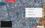
Here's the web page and a picture of what I did. When I tried to post this reply, it said files are still being uploaded. Do you want to continue. WTF?


Screenshot_20240330_194334.jpg
 
So I found a web page that talks about this. The guy says touch the i, and uncheck altitude zone. The only problem is, I did that, and it doesn't work!

Here's the web page and a picture of what I did. When I tried to post this reply, it said files are still being uploaded. Do you want to continue. WTF?


View attachment 173933
That's the Blue Authorization Zone that you must unlock to fly in, but you can also uncheck to clear that map layer. Just uncheck all the boxes if you only want to see a clear screen everywhere. However, they are reset back to "on" every time you reopen the app, or change batteries.
 
Last edited:
Why would you want to keep them in the same directory? That's why we have directories, to organize the files on our computer. I guess if you wanted to, you could have every single file on your computer in the same directory. I always move LRF and SRT files into different directories. I'm not stupid, like the people at DJI.
I never said you would want to keep them in the same directory, but they are recorded into the same directory by DJI. If you also create separate directories for each upon import, as I do, you'll be fine.
 
I know I can do that, but I shouldn't have to. That's my point. And I certainly wouldn't switch to apple's .mov format to solve this problem. That a totally different codex and container that I want my files to be. I'm an Windows and Android person.
Windows has no problem recognizing and playing .mov files. It's just a container. Premiere Pro handles both equally upon import. Export into whatever codec you want. I import as .mov and I export as .mp4 to know which are which. You can even rename the *.LRF files *.mov if you like. Any recognizable video extension will work.
 
However, they are reset back to "on" every time you reopen the app, or change batteries.
How stupid is that? So every time I fly, I have to do that to have a good looking map? I'm going to be sending DJI some really nasty emails about this. Their ears will be ringing. I know it's not your fault gagetguy.
 
Windows has no problem recognizing and playing .mov files. It's just a container. Premiere Pro handles both equally upon import. Export into whatever codec you want. I import as .mov and I export as .mp4 to know which are which. You can even rename the *.LRF files *.mov if you like. Any recognizable video extension will work.
I know windows can play .mov files. But i want .mp4 files. I keep and watch the exact 4k files that come off the drone. Why would I use Priemer, or any other video editing program? If you use any of these programs, and reencode, you will lose quality. I only do a lossless join with avimux. That's what I watch on my 65 inch TV.
 
Yes it is. You ars seeing different layers.
If you look at the picture on post #6, you can clearly see that on the far right the map the contrast is high, on most of the map, to the left, the contrast is low, and altitude zone is unchecked. So it's not working. That picture was taken when my tablet was not connected to the RC or drone. I will try tomorrow, when I'm totally connected.

The guy said do this. The guy says touch the i, and uncheck altitude zone. But maybe you have to uncheck authorization zone too.
 
If you look at the picture on post #7, you can clearly see that on the far right the map the contrast is high, on most of the map, to the left, the contrast is low, and altitude zone is unchecked. So it's not working. That picture was taken when my tablet was not connected to the RC or drone. I will try tomorrow, when I'm totally connected.
You need to zoom out. The altitude zone IS OFF! Look at the layer list.
 
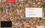
I just tested it. The guy was wrong. You have to uncheck authorization zone, not altitude zone.

Screenshot_20240330_233840.jpg
 
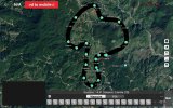
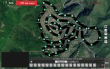
Kind of off topic, but here are the first two waypoint missions for the Banaue rice terraces.
What do you think?

Screenshot_20240330_234339.jpg

Screenshot_20240330_234217.jpg
 

DJI Drone Deals

New Threads

Forum statistics

Threads
131,195
Messages
1,560,783
Members
160,161
Latest member
Keith J