Wide angle, 180, vertical and 360What other pano modes does it have, vertical and 180 in addition to the 360?
Wish it had custom modes, like you specify the number of rows and columns.
You are using an out of date browser. It may not display this or other websites correctly.
You should upgrade or use an alternative browser.
You should upgrade or use an alternative browser.
My first 360° Pano with the Air3
- Thread starter mic.kue
- Start date
No, 180 is wider.Is wide angle wider than 180?
How many shots for WA vs for 180?
I would have to check how many images are taken.
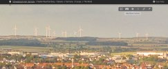
Perfect! I can now clearly see the windmill farm on the horizon, and all the detail I would expect, when zooming in!Take a look here for higher resolution:

Kocherschleife, Schwäbisch Hall 360 Panorama | 360Cities
360° panorama photo from Schwaebisch Hall, Germany by Michael Kühneisen.www.360cities.net
The newly improved resolution of 50,000 x 25,000 makes a huge difference, compared to Kuula's mere 16,384 x 8,192!

Last edited:
Just for your information,the max image wide on kuula 16000px, not 16mb and the air3 takes 33 images for a panorama
Thanks for the corrections. I don't yet have an Air 3 to test. All other DJI 360 panos are from only 25 images. That extra top row of 8 images isn't very helpful when the horizon is in the middle, and there is only empty sky above it, without any detail for stitching. However, being able to include 60° up would certainly help with tall buildings from beneath them, that otherwise get smudged in the ceiling cloning! Maybe that also explains why the automated stitching has been dodgy. Never really had a problem with the 25 images with the ceiling cloning. How large is the 33 image in camera stitch jpg in MB?
I thought I read on the Kuula website that the max resolution was 16MB.
"Maximum supported image dimensions are 16384 x 8192 pixels (16K)."
However, they state the size in MB is not limited….Hmmm
It's 16K pixels, not MB!
How many bits per pixel are used for the original Air 3 still images?
Are the 33 images taken using the 12MB or 48MB still resolution for the pano?
In any event, Kuula's rendering certainly doesn’t hold a candle to the 360Cities rendering on my iPad, and Kuula also limits the mobile device dimension rendering to only 4096 x 2048, which is a mere 25% of the desktop size, and I am on an iPad, so that's all I can see from their website.
"On desktop computers and laptops, Kuula uses the full size image or 8192 x 4096 pixels, whichever is smallest. On mobile devices, 4096 x 2048 pixel images are used."
Awesome image when seen on 360Cities!
Just wish they wouldn't limit me to a small window view in the browser.
iPad sadly won't let it display in true full screen.
Last edited:
Nice! Question though: Why didn't you just accept the drone's stitching?Feel free to take a look at it:
HERE
It was manualy stiched, zenith was filled in PS.
I am pretty satisfied with the drone so far.
The only thing i noticed is, that the automatic mode didn't work so well.
It's better to dial in the values.
Because I like self-stichted one better.Nice! Question though: Why didn't you just accept the drone's stitching?
Well that makes sense; thanksBecause I like self-stichted one better.
DJ Wes
Well-Known Member
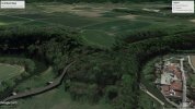
It definately looks weird from that 360 degree pano. However, looking at that location in Google Earth Pro shows that the tracks must go through a short tunnel and then into a valley/gulley on the other side. When there are elevation changes and roads or railway tracks, Google Earth Pro sometimes makes them look quite strange.It appears that the railroad tracks cross that small creek and then end in the woods. Is that real? Would you share the location so we can look at the area on Google Maps?

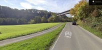
I think you're right. Here's a view from the road on the north side of the field seen in the bottom left of the image you posted. That's the railroad tracks crossing over the roadway.It definately looks weird from that 360 degree pano. However, looking at that location in Google Earth Pro shows that the tracks must go through a short tunnel and then into a valley/gulley on the other side. When there are elevation changes and roads or railway tracks, Google Earth Pro sometimes makes them look quite strange.
View attachment 167126
Mystery solved.

Last edited:
How large in MB is the HiRes 33 image "in camera" stitch jpg?Because I like self-stichted one better.
How many bits per pixel are used for the original Air 3 still images?
Are the 33 images taken using the 12MB or 48MB still resolution for the pano?
I think you're right. Here's a view from the road on the north side of the field seen in the bottom left of the image you posted. That's the railroad tracks crossing over the roadway.
Mystery solved.
View attachment 167127
I have a hard time understanding what's the problem. But I guess it's because I am used to the landscape and the track.
How large in MB is the HiRes 33 image "in camera" stitch jpg?
How many bits per pixel are used for the original Air 3 still images?
Are the 33 images taken using the 12MB or 48MB still resolution for the pano?
- About 25-30mb
- 8bit (24 in total)
- it uses the 12mp images to generate a 12000x6000px pano (72mp).
Everyone was wondering about the area where the railroad tracks completely disappear into the forest. Is there no tunnel, or are the tracks just the hidden under the canopy of trees, before it comes out the other side, seemingly having shifted significantly from straight through?I have a hard time understanding what's the problem. But I guess it's because I am used to the landscape and the track.
- About 25-30mb
- 8bit (24 in total)
- it uses the 12mp images to generate a 12000x6000px pano (72mp).
Thanks for the "in camera" pano details.
The Mavic 3 series HiRes "in camera" stitch from its twenty-five 20MP images is almost 3x as large at 65-75MB, so much more detail. Mavic 3 only elevates 12° above horizontal during the pano shooting, so more sky has to be cloned in, but the terrestrial detail is still far greater at 20MP than 12MP.
izometric
Well-Known Member
I saw some automatic 360x180 panoramas shot with Air 3 and they still have a hole in the sky. I wonder why is that, since the drone can lift the gimbal to 60 degrees, just like the Mini 3 Pro. The Mini 3 pro leaves a minuscule rectangular patch. I solve that patch by manually shooting 2 more dng photos in vertical mode immediately after the automatic panorama.
Can you confirm how many automatic shots does the Air 3 take in a 360 panorama? The Mini 3 Pro takes 35 shots.
Can you confirm how many automatic shots does the Air 3 take in a 360 panorama? The Mini 3 Pro takes 35 shots.
I am being told 33 images of 12MP each, which is 4 rows of 8 every 45°, plus one straight down. It's the same 24mm equivalent FOV as all the other drones. The Mavic 2 and the Mavic 3 series all clone in a ceiling in the automated 360° in the in camera stitch. Odd that the Air 3 doesn’t do that, instead doing a crappy alignment of 33 images, 8 of which are sky, without any detail for stitching!I saw some automatic 360x180 panoramas shot with Air 3 and they still have a hole in the sky. I wonder why is that, since the drone can lift the gimbal to 60 degrees, just like the Mini 3 Pro. The Mini 3 pro leaves a minuscule rectangular patch. I solve that patch by manually shooting 2 more dng photos in vertical mode immediately after the automatic panorama.
Can you confirm how many automatic shots does the Air 3 take in a 360 panorama? The Mini 3 Pro takes 35 shots.
Similar threads
- Replies
- 23
- Views
- 5K
- Replies
- 5
- Views
- 770
DJI Drone Deals
New Threads
-
-
Selling a Care Refresh replacement drone question
- Started by kanesimages
- Replies: 2
-
Air 2 Best Of | Portugal Like You’ve Never Seen It
- Started by Daniel Boavida
- Replies: 3
-
-
Members online
Total: 4,864 (members: 10, guests: 4,854)


