DJI Mavic, Air and Mini Drones
Friendly, Helpful & Knowledgeable Community
Join Us Now

Never happened before

sawyerbrownlive

Well-Known Member
Joined
Jan 27, 2017
Messages
55
Reactions
21
Age
46
Any input is appreciated. Been flying for 5 years, hundreds of hours, zero problems. Yesterday on a gorgeous sunny day i flew towards a mountain my wife/friends were hiking. 8000' from launch in a near straightline, i spotted them and started to record. As they spotted me and started to pose for the camera, i lost connection. 30' above them and i had no control as it just hovered. RTH didn't work on my tablet or controller. I rebooted the tablet but nothing changed. I drove to within 500' of it hoping it would reconnect, no luck. When the battery drained i got a "force landing" notification. It landed hard on a rock and did some damage. Wife was able to retrieve it. I've looked at my settings and it is set to RTH (not hover) when i lose connection. This makes no sense to me. The only notifications i received was "ambient lighting" and "max altitude reached." I will make necessary repairs as this is my favorite hobby, and i mostly fly to areas that i would never be able to retrieve it if this kind of problem happens. I got lucky this time that wife was nearby. But i'm a little shy about flying like that until i know what caused the problem and how to avoid/correct. Any advice or input? Thanks in advance!
 
Any input is appreciated. Been flying for 5 years, hundreds of hours, zero problems. Yesterday on a gorgeous sunny day i flew towards a mountain my wife/friends were hiking. 8000' from launch in a near straightline, i spotted them and started to record. As they spotted me and started to pose for the camera, i lost connection. 30' above them and i had no control as it just hovered. RTH didn't work on my tablet or controller. I rebooted the tablet but nothing changed. I drove to within 500' of it hoping it would reconnect, no luck. When the battery drained i got a "force landing" notification. It landed hard on a rock and did some damage. Wife was able to retrieve it. I've looked at my settings and it is set to RTH (not hover) when i lose connection. This makes no sense to me. The only notifications i received was "ambient lighting" and "max altitude reached." I will make necessary repairs as this is my favorite hobby, and i mostly fly to areas that i would never be able to retrieve it if this kind of problem happens. I got lucky this time that wife was nearby. But i'm a little shy about flying like that until i know what caused the problem and how to avoid/correct. Any advice or input? Thanks in advance!
I'm guessing the flight logs would help so I'd encourage you to have those ready. However, I'm thinking that maybe the drone didn't lose connection to the controller and it was just the tablet. If indeed that was the case, it would have stayed in that position. However, that idea falls apart because you said that you had no control whatsoever.
 
I'm working on getting the logs uploaded. Never done that so give me a few. Yea i had no control. Tried RTH on the tablet and on the controller.
 
Hopefully i've done this right. I'm anxious to see what happened....and curious to know what magic you people have to be able to deduce from the records what might have happened!
 

Attachments

  • DJIFlightRecord_2021-10-09_[10-05-54].txt
    807.6 KB · Views: 30
  • DJIFlightRecord_2021-10-09_[10-25-42].txt
    6.4 KB · Views: 16
Just to confirm some details , were you flying between and below the Mountains as that might have been just to much interference for the drone to navigate the RTH , it will be interesting to see what the logs show.

Phantomrain.org
Gear to fly in the Rain.
 
Just to confirm some details , were you flying between and below the Mountains as that might have been just to much interference for the drone to navigate the RTH , it will be interesting to see what the logs show.

Phantomrain.org
Gear to fly in the Rain.
Are you able to see the logs? So i was next to a large rock. I said mountain in my OP but indeed it is a gigantic rock. I was about 30' above a flatish area and 30' or so away from the side of the rock. The rock wall extends up probably 100' higher than my Mavic. There are other much smaller rocks nearby....however i had flown in a straight line to the point it lost connection. I did not fly behind or under anything. While there was a huge rock wall to my right, and much smaller rocks to the left and in front and below....there was nothing between the Mavic and where i launched except open field.
 
Hopefully i've done this right. I'm anxious to see what happened....and curious to know what magic you people have to be able to deduce from the records what might have happened!

Those are the correct TXT log files, but I think this is going to require the aircraft DAT file for that flight (ending FLY111.DAT).
 
  • Like
Reactions: MARK (LI)
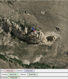
My guess is the drone went behind the rock spire, the controller signal was lost, and the drone tried to return to home, but crashed into the side of the rock. Not sure what the "controller can't change modes" is all about.


The useful one ...

DJIFlightRecord_2021-10-09_[10-05-54].png
 
Last edited:
Dat files! This flight was at Dripping Springs in Las Cruces. You are in Los Alamos so you might have a good idea of where i'm talking about.
 

Attachments

  • 2021-10-09_10-05-43_FLY111.DAT
    2.4 MB · Views: 10
  • 2021-10-09_11-23-41_FLY113.DAT
    8.8 MB · Views: 9
Why would the RTH path make a hard right and go someplace that was nowhere near home? More importantly...why did i lose connection and never regain it, even after i drove up to within a few hundred feet of it?
sar104 knows this stuff - so if he says I am wrong, I trust him.

The blue arrow in my sketch is pointing toward your home point, and is what I'd expect the drone to have done. I overlooked the battery levels in the second log showing a forced landing. Maybe collision avoidance braked the drone next to the rock, and it hovered until it landed hard.

You have two logs, so there was a brief connection at some point several minutes after you lost control. Then the battery died.

Did you find the drone near the rock?

Capture.JPG
 
Last edited:
  • Like
Reactions: NedKelly
1633882959861.png
After several minutes of no control and no transmission, i drove to the picnic area you see here at the bottom left. Yes there was a large rock between me and the Mavic.
 
sar104 knows this stuff - so if he says I am wrong, I trust him. The blue arrow in my sketch is pointing toward your home point, and is what I'd expect the drone to have done.

You have two logs, so there was a brief connection at some point several minutes after you lost control.

Did you find the drone near the rock?

View attachment 136293
My wife retrieved it straight below where it hovered for 10-15 minutes.
 
Dat files! This flight was at Dripping Springs in Las Cruces. You are in Los Alamos so you might have a good idea of where i'm talking about.
I am familiar with that location - as it happens I had a search and rescue incident right there a few weeks ago, when some teenagers lost the trail after dark and became stranded on the slope below where this happened.

Those files are the mobile device DAT files, but since the aircraft had disconnected from the device, it's the aircraft DAT files that matter. You will have to connect to the aircraft to retrieve those.
 
I'm out of my league. I don't know anything about getting files off the aircraft. I looked at the guide in your signature but it says that i need DJI assistant 2. I can't even find that.
 
sar104 knows this stuff - so if he says I am wrong, I trust him.

The blue arrow in my sketch is pointing toward your home point, and is what I'd expect the drone to have done. I overlooked the battery levels in the second log showing a forced landing. Maybe collision avoidance braked the drone next to the rock, and it hovered until it landed hard.

You have two logs, so there was a brief connection at some point several minutes after you lost control. Then the battery died.

Did you find the drone near the rock?

View attachment 136293
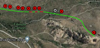
I think your basic hypothesis is correct. The failsafe was set to RTH, and the signal was lost when the aircraft went behind the rock. The Mavic Pro doesn't have failsafe retrace, and so it headed directly back towards the home point. Unfortunately it had already reached its set maximum flight altitude (200 m), and so when it encountered the spire it was unable to climb over it, and instead hovered until smart-battery forced landing. The aircraft DAT will likely confirm that.

In the image below, the green line is the direct path home:

grab11.jpg
 
  • Like
Reactions: NedKelly
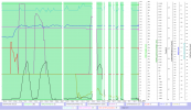
Your first TXT log ended at around 343sec with 64% battery ... your craft was then up on the max set height (200m) & the connection started to be sketchy (white vertical stripes in the chart=disconnected). All RC commands was nicely obeyed by the craft as shown in the data compiled in the chart.

Dotted graphs is the stick inputs ... Rudder (red) correlates to a yaw movement (blue), Elevator input (purple) correlates nicely to heading speed changes (black) ... and throttle commands (yellow) fits nicely to changes in the vertical Z-speed (light blue).

All was normal ...

1633882946604.png

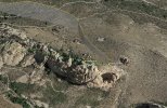
... and your craft was here when the first log ended ... note at the big red arrow that the mobile device location is included in the data (explain further below...)

1.jpg

When the log recording continues (the second .TXT log) the timing is 1188sec & the battery is down at 1% & the craft is lowbattery auto landing. No stick inputs is made what so ever. & the connection is still sketchy (white vertical stripes in the chart=disconnected).

1633883607989.png

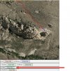
... and the craft is now here & are descending, the second log ends at 181,9m height relative the HP. Also note that during this short second log no mobile device position data is included anymore.

1633883638767.png

So what happened in between those 2 logs separated with 845sec & 63% battery ..?

My firm belief is that this was due to a disconnect between your RC & mobile device ... the craft obeyed all inputs it got according to the logs ... it had moved horizontally in between the 2 logs (due to that you fiddled with the sticks & the craft & RC still was connected) ... & in the first log the mobile device position was included in the data but not in the second.

So why didn't it make a low battery RTH ? I believe it actually did ... but either you canceled it unintentionally by pushing the RTH button on the RC, below from the manual... or it encountered an obstacle blocking it's way & the OD sensors stopped it.

2.jpg

The mobile device DAT log you included pretty much confirms my idea about the RC/mobile device disconnect ...

3.jpg

In order to know more about what happened in between those 2 log recording occasions the craft DAT log is needed.
 
Last edited:
  • Like
Reactions: NedKelly
Lycus Tech Mavic Air 3 Case

DJI Drone Deals

New Threads

Forum statistics

Threads
130,601
Messages
1,554,302
Members
159,608
Latest member
carlos22