DJI Mavic, Air and Mini Drones
Friendly, Helpful & Knowledgeable Community
Join Us Now

Newbie question

NAPA15RT

Member
Joined
Nov 30, 2020
Messages
11
Reactions
10
Age
52
Location
Belmont, California
Hi, Just wondering. I am planning on practicing at a local field at a school. Shouldnt be any problems with people. Question is do you always have to get authorization on the b4ufly app ? It says controlled airspace. Airspace authorization required. get LANNC. If I click Get LANNC will I be good to go ? 100ft limit which is fine because i just want to just learn controls.

Thanks and hope this is not a dumb question.
 
Depends on the airspace. I've never needed to use LANNC where I fly and use Airmap for basic info but have never used B4UFly. It depends on where you are in a specific class of airspace. Some areas are at 0 AGL. Can you find a GIS map on line.

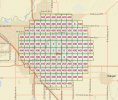
Does your app show a grid like this where you plan to fly?
gis.JPG
 
I just dont fully get how it works. How does anyone even know where your flying in the first place besides seeing it in the air ?
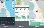
In addition to B4UFly, there are two other apps that you might try that do similar things: Airmap (as recommended above) and Kittyhawk. They all do similar things. Below is a photo of screenshots of all three apps. You may prefer one over another, but they all work. The map will tell you when you need LAANC authorization and you can request it through any of these apps. Another handy app to have on your phone is UAV Forecast, which gives you wind and GPS data.

You may find it important, if not critical to your flight if you check the flight location before you go there. DJI has something called "geofencing", and though you may have LAANC authorization you may need to separately unlock the geofence so your drone can take off. I ran into that at a friend's house when his house was 1/2 block inside the geofence and the drone would not start or take off. I had to contact DJI to get the area unlocked. Kittyhawk is more helpful identifying those sorts of issues as you can see the color coding within the restricted space.

airspace_maps.png
 
Last edited:
  • Like
Reactions: drakkor and Pautna
thanks for the reply. Where i am at I am close to a small airport. So the grid says 100ft to 200ft. So i am good in those areas to fly at that altitude. But my main question is do i need to do the lannc thing or just fly with the rules for that area ?
 
thanks for the reply. Where i am at I am close to a small airport. So the grid says 100ft to 200ft. So i am good in those areas to fly at that altitude. But my main question is do i need to do the lannc thing or just fly with the rules for that area ?
Noting that you are in Belmont California, I will assume that you are close to San Carlos Airport which is Class D airspace. Class D extends from the surface to 2500' AGL (above ground level) and requires ATC (LAANC) authorization. How high you will be permitted to fly will largely depend on how close you are to the airport. When you apply for LAANC through one of the apps it will ask you how high you intend your missions to be and the area in which you will fly. I'm sure one of the other forum members will be able to direct you to getting more specific information without trial and error of how high you may be permitted to fly within the area.

While not (yet) required, it might be helpful in your spare time to begin studying for the Part 107 Airman's Knowledge Test, specifically focusing on airspace. Being in California with a varying topography, you will find it helpful to be able to read air sectional maps like the one in the link below, which I think is your area. I think some sort of testing for all drone pilots is coming down the pike. You may want to get ahead of the curve on that one.

Sectional map near San Carlos Airport
 
  • Like
Reactions: Pautna and NAPA15RT
It says controlled airspace. Airspace authorization required. get LANNC.
This is what matters (and why you should always check B4Ufly). As suggested, get Airmap (or something similar) so you can submit for approval. What I don't know is if you can get some sort of "recurring" approval if you intend to repeatedly fly in that area. FWIW, I also use my nearby elementary school for "flight training" (on the weekends).
 
  • Like
Reactions: NAPA15RT
Do they ever deny you from flying ?
This is what matters (and why you should always check B4Ufly). As suggested, get Airmap (or something similar) so you can submit for approval. What I don't know is if you can get some sort of "recurring" approval if you intend to repeatedly fly in that area. FWIW, I also use my nearby elementary school for "flight training" (on the weekends).
I am pretty far away from the san carlos airport but close enough to be in that grid. So i think i am understanding that it is good to always use one of the apps and get auth to fly if your in that type of area ?
 
  • Like
Reactions: Pautna
I'm pretty sure Kittyhawk now operates B4UFly. I use Kittyhawk and love it. Permission in my Class C airspace takes just a few moments.
 
Do they ever deny you from flying ?

I am pretty far away from the san carlos airport but close enough to be in that grid. So i think i am understanding that it is good to always use one of the apps and get auth to fly if your in that type of area ?
If you are inside that grid, you are required to get approval through LAANC to fly.
 
  • Like
Reactions: NAPA15RT
Thanks for all the help. One last probably dumb question. Is there really people that will come find you if you violate the rules? Not that I would.
 
thanks for the reply. Where i am at I am close to a small airport. So the grid says 100ft to 200ft. So i am good in those areas to fly at that altitude. But my main question is do i need to do the lannc thing or just fly with the rules for that area ?
Thanks for all the help. One last probably dumb question. Is there really people that will come find you if you violate the rules? Not that I would.
Yes you need LANNC and must follow those height restrictions. Will someone come to get ya if you fly for example slightly above one of the grid designated heights for a minute or so, no I doubt you'd be targeted, but if for some reason you drift out of compliance and something goes wrong, it might not look good in court. If you were unlucky enough to hit a manned aircraft in that situation, you'd be responsible for your actions. Hard to say you were trying to see and avoid aircraft when you're not supposed to be there in the first place. Even if you are flying in compliance, an aircraft strike will result in an investigation. You just have more credibility when flying in compliance. Your choice.
 
  • Like
Reactions: Pautna and NAPA15RT
I haven't used B4UFly in some time. Last I used it, it showed the grid but couldn't submit LAANC authorization requests. Airmap and Kittyhawk were the only apps available even though Kittyhawk was contracted to continue development of B4UFly. Has B4UFly been updated to provide LAANC services?

The LAANC apps will default to using your current location as where you intend to fly, but you can change that.

Fun fact: DJI was approved as a LAANC provider and DJI had planned to integrate LAANC into Go, but never did. Had they done so, that would have provided the ability to automatically unlock an authorization zone after having obtained LAANC authorization.
 
  • Like
Reactions: NAPA15RT
I just reinstalled B4 and answered my question. There's a button to "get LAANC" but that just directs you to download Kittyhawk.
 
While its always good to know where you can and cannot fly, by checking Airdata or B4UFly, once you've noted that your in an area that requires authorization, unless there is a specific reason you want to fly there, it may be simpler to merely locate a place to fly where you do not need to go through authorization hoops unless you really need to. There are probably wide areas within some short travel time that you can go to perhaps to fly without needing to use LAANC.
 
Thanks guys. Great help. My first try will be in a field at a local school. With the limit at 100feet. Just want to practice. Never flown a drone before. I will request auth and see what happens.
 
  • Like
Reactions: Pautna
While its always good to know where you can and cannot fly, by checking Airdata or B4UFly, once you've noted that your in an area that requires authorization, unless there is a specific reason you want to fly there, it may be simpler to merely locate a place to fly where you do not need to go through authorization hoops unless you really need to. There are probably wide areas within some short travel time that you can go to perhaps to fly without needing to use LAANC.
Well controlled airspace is usually a 5 mile radius from airports and many smaller regional airports have controlled airspace. As long as you're not too close to the airport or under runway approach path, many areas are just fine to fly in and not a big deal to get authorization. Many 1 mile grids even have a 400ft ceiling.
 
  • Like
Reactions: WWMav
Well controlled airspace is usually a 5 mile radius from airports and many smaller regional airports have controlled airspace. As long as you're not too close to the airport or under runway approach path, many areas are just fine to fly in and not a big deal to get authorization. Many 1 mile grids even have a 400ft ceiling.
In my area, there are lots of open areas in which to fly, I realize thats not the case in some places for some pilots perhaps if you want to stay close to home to fly, specially if you live near an airport and within the "zone".

While its relatively easy perhaps to gain that authorization, for the new pilot, its not straight forward. Perhaps there should be a pinned tutorial somewhere in the forum for that process that can be pointed to when the question arises and updated if the process changes or new software comes along that does it or existing apps are updated. Or perhaps if there are some good videos on the process that could also be part of tutorial posting... now if their already is one, and I haven't spotted it , point away,..

thanks
 
  • Like
Reactions: NAPA15RT
Lycus Tech Mavic Air 3 Case

DJI Drone Deals

New Threads

Forum statistics

Threads
131,096
Messages
1,559,804
Members
160,079
Latest member
calezu