

Was flying just outside of airport 5 mile NFZ. An alarm message of altitude restriction kept appearing on my monitor. Message read altitude 393ft. restricted altitude zone. I'm at only 50 ft. above ground. I know there are altitude restrictions beyond the 5 mile NFZ. The Visualize FAA UAS map shows the altitude restrictions. In this case the restriction was 400 ft. Now the area I was flying at is well above the airport altitude. I always assumed altitude restrictions are above the ground your standing on when flying. Am i right or wrong?
You are using an out of date browser. It may not display this or other websites correctly.
You should upgrade or use an alternative browser.
You should upgrade or use an alternative browser.
NFZ I'am confused
- Thread starter Lubar
- Start date
Was flying just outside of airport 5 mile NFZ. An alarm message of altitude restriction kept appearing on my monitor. Message read altitude 393ft. restricted altitude zone. I'm at only 50 ft. above ground. I know there are altitude restrictions beyond the 5 mile NFZ. The Visualize FAA UAS map shows the altitude restrictions. In this case the restriction was 400 ft. Now the area I was flying at is well above the airport altitude. I always assumed altitude restrictions are above the ground your standing on when flying. Am i right or wrong?
That should be correct - the aircraft doesn't pay attention to altitude MSL, only altitude relative to take off. It does raise an interesting question about how the graded altitude limits around airports work in hilly terrain.
lertsek
Well-Known Member
- Joined
- Oct 15, 2018
- Messages
- 93
- Reactions
- 83
- Age
- 66
How exactly does the drone know its altitude? Is it by GPS, or could the barometric pressure have caused the erroneous reading?That should be correct - the aircraft doesn't pay attention to altitude MSL, only altitude relative to take off. It does raise an interesting question about how the graded altitude limits around airports work in hilly terrain.
How exactly does the drone know its altitude? Is it by GPS, or could the barometric pressure have caused the erroneous reading?
It has both 3-D GPS and barometric data but it's primary altitude reference uses the barometric pressure relative to the pressure at takeoff. It's not going to be hundreds of feet in error. That said, it wasn't clear from your first post that it was trying to tell you that your altitude was 393 ft. You would need to look at the actual flight logs to find out what was happening - speculating based on somewhat confusing messages isn't going to lead to a definitive explanation.
The altitude on my monitor was only 50ft. The caution altitude restriction (yellow color) that appeared several times went away so quick I didn't have time to read it thoroughly. That is why I asked the question, to see if anyone else had a similar incident. Flight logs, don't know how to access those.It has both 3-D GPS and barometric data but it's primary altitude reference uses the barometric pressure relative to the pressure at takeoff. It's not going to be hundreds of feet in error. That said, it wasn't clear from your first post that it was trying to tell you that your altitude was 393 ft. You would need to look at the actual flight logs to find out what was happening - speculating based on somewhat confusing messages isn't going to lead to a definitive explanation.
YaSureOK
Active Member
Was flying just outside of airport 5 mile NFZ. An alarm message of altitude restriction kept appearing on my monitor. Message read altitude 393ft. restricted altitude zone. I'm at only 50 ft. above ground. I know there are altitude restrictions beyond the 5 mile NFZ. The Visualize FAA UAS map shows the altitude restrictions. In this case the restriction was 400 ft. Now the area I was flying at is well above the airport altitude. I always assumed altitude restrictions are above the ground your standing on when flying. Am i right or wrong?
I have the exact same situation. I am 8 miles from a regional airport and only a grass strip and a seaplane base within the 5 mile radius so when I first got this message a few weeks ago I was confused as well. It appears that my house is under one of the runway approaches at the regional airport. I looked at the geo zone map on the site below and found my house. I am in the marked gray area outside the 5 mile radius so I believe the DJI GO 4 recognizes that and is giving a warning and placing a max altitude AGL restriction on my drone. I haven't attempted to go above that limit but my guess is that I wouldn't be able to even if I tried. I previously talked to a couple air traffic controllers to see what minimum altitude planes would be flying over my house and both told me 1000'. FInd your house on the map at this site to see if this explains it for you. DJI - The World Leader in Camera Drones/Quadcopters for Aerial Photography
Lucky you that you only have an altitude restriction. I'm now grounded because of glide slope, even at just under 5 miles from the airport.
Airmap does claim the ceiling is 0ft at my house but that's ridiculous. A plane would hit power distribution lines after going 1/2 mile past my house if they weren't at least 200ft. They normally would be at least 1000ft.
Airmap does claim the ceiling is 0ft at my house but that's ridiculous. A plane would hit power distribution lines after going 1/2 mile past my house if they weren't at least 200ft. They normally would be at least 1000ft.
packnrat
Well-Known Member
Sad but this restriction on us is wrong in so many ways.
Even a old quary have been flying at, it is by the B4UFly fly app says, and checking online maps, as well as a paper map. All say I am at 6 miles+ away. in a little “protected” valley. hills way more than a meair 400 feet above my on three sides. and between me and said airport.
I get a warning. And at times my drone stops mid flight. And only very slowly putters back to me.
Last edited:
Sad but this restriction on us is wrong in so many ways.
Even a old quaryI have been flying at, it is by the B4UFly fly app says, and checking online maps, as well as a paper map. All say I am at 6 miles+ away. in a little “protected” valley. hills way more than a meair 400 feet above my on three sides. and between me and said airport.
I get a warning. And at times my drone stops mid flight. And only very slowly putters back to me.
The GEO system is still a bit crude in that it doesn't take terrain into account. Which category of airspace are you in according to the GEO system? And which class of airspace are you in?
packnrat
Well-Known Member
i would have to look at a chart to know the "class" of the air space. no planes fly over this area, but the 5 mile mark that i checked, is a straight line.
i live and play in hills. if any plane tried to fly in the quarry, they would crash, as this area is too small for them. in fact (need to check) but i believe the tops of these hills are below the level of the runway at that airfield. as this old quarry in the side of a canyon.
airport is columbia out of sonora, ca. there runway is 2118 above sea level.
as per there web site air traffic is required to fly to the west of the runway. noise, school, historical tourist town. i am well east of a straight line off there runway going north-east. other side of a river/lake, canyon, and even another county. it is a old cement quarry, called camp 9. (real name ?) it is on of all things... camp 9 road.
best i can tell there web site is a bit out of date. "drone rules list a 2016 date".
i did send a email to there address, but have received nothing back.
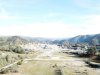
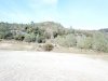
here is a photo.

i live and play in hills. if any plane tried to fly in the quarry, they would crash, as this area is too small for them. in fact (need to check) but i believe the tops of these hills are below the level of the runway at that airfield. as this old quarry in the side of a canyon.
airport is columbia out of sonora, ca. there runway is 2118 above sea level.
as per there web site air traffic is required to fly to the west of the runway. noise, school, historical tourist town. i am well east of a straight line off there runway going north-east. other side of a river/lake, canyon, and even another county. it is a old cement quarry, called camp 9. (real name ?) it is on of all things... camp 9 road.
best i can tell there web site is a bit out of date. "drone rules list a 2016 date".
i did send a email to there address, but have received nothing back.
here is a photo.
In another thread discussing the new NFZ, if it is a blue zone, then you can unlock. You will need internet, and possibly access to SMS. The prompts to unlock come up when you try to fly.
You probably should not be flying in a red zone.
You probably should not be flying in a red zone.
i would have to look at a chart to know the "class" of the air space. no planes fly over this area, but the 5 mile mark that i checked, is a straight line.
i live and play in hills. if any plane tried to fly in the quarry, they would crash, as this area is too small for them. in fact (need to check) but i believe the tops of these hills are below the level of the runway at that airfield. as this old quarry in the side of a canyon.
airport is columbia out of sonora, ca. there runway is 2118 above sea level.
as per there web site air traffic is required to fly to the west of the runway. noise, school, historical tourist town. i am well east of a straight line off there runway going north-east. other side of a river/lake, canyon, and even another county. it is a old cement quarry, called camp 9. (real name ?) it is on of all things... camp 9 road.
best i can tell there web site is a bit out of date. "drone rules list a 2016 date".
i did send a email to there address, but have received nothing back.
here is a photo.
View attachment 55991
That looks like an error in the GEO database. Columbia (O22) is under 700 ft Class E, so it's in Class G airspace. That class of airport generally has the enhanced warning zone runway extensions, not authorization zones. The other airports in that vicinity are good examples.
packnrat
Well-Known Member
That looks like an error in the GEO database. Columbia (O22) is under 700 ft Class E, so it's in Class G airspace. That class of airport generally has the enhanced warning zone runway extensions, not authorization zones. The other airports in that vicinity are good examples.
not up on "enhanced? zones. but i finally found one of those airport circle maps. it lists this quarry on the wrong side of the river, placing it in the circle, not out of it.
but Rasmussen field CPU claveras county, i did get to talk ftf with them. and they have NO problems with me doing ad-hock (flying well under 100 ft. very limited use and distance, (my choice) -- way too many trees and "other" problems) flying in and around my house. san andreas well within the 5 miles. the rest of this area is heavy with trees and/or privet property,
there is a hospital in town. but i can say i can not recall it ever using there landing pad.( and that's a good thing in many ways)
west of town (not listed) is a elephant zoo for the filthy rich, they get flown in.
then the army core of tax wasters. the general flys in (once a year for one week.."inspection" right...) a military copter to a lake outside of valley springs. again the pad is not listed.
Enhanced warning zones just require you to acknowledge that you understand that you are in one - no account connection required.
packnrat
Well-Known Member

packnrat
Well-Known Member
Ok get this. But the air space leaving the airport toward my area is not used cause of a tourist trap town, school, pop. Has a couple labels, but as per what I read on the airports web site. Or on info about this. No aircraft are allowed to approach or depart that way. If they can. For some reason they never get even within hearing distance of me. Let alone visible.
Maybe if I get stupid I will try and get to the top of the hill between me and the airport. Sit there a while and see/ hear anything.
as I never fly that high. It must be a good 700-800 feet agl for me. ( not a pro, or crazy so just taking it easy and having fun).
I believe more in glide path than circles. so yes worth it for me to look closer.
Ok get this. But the air space leaving the airport toward my area is not used cause of a tourist trap town, school, pop. Has a couple labels, but as per what I read on the airports web site. Or on info about this. No aircraft are allowed to approach or depart that way. If they can. For some reason they never get even within hearing distance of me. Let alone visible.
Maybe if I get stupid I will try and get to the top of the hill between me and the airport. Sit there a while and see/ hear anything.
as I never fly that high. It must be a good 700-800 feet agl for me. ( not a pro, or crazy so just taking it easy and having fun).
I believe more in glide path than circles. so yes worth it for me to look closer.
My local airport has the same situation - no departures to the west or arrivals from the west allowed. But the GEO system doesn't know that, apparently, and so the enhanced warning zones on the extended runway centerlines go both east and west. Not really a problem since those only require acknowledgement though, and I haven't bothered to submit a ticket on that.
2nckayakers
Well-Known Member
I have the same situation at my house. I am in class G up to 700 at the Class E and it makes me unlock it as dji lists to as an authorization zone.That looks like an error in the GEO database. Columbia (O22) is under 700 ft Class E, so it's in Class G airspace. That class of airport generally has the enhanced warning zone runway extensions, not authorization zones. The other airports in that vicinity are good examples.
packnrat
Well-Known Member
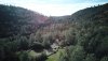
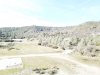
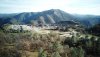
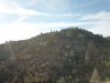
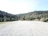
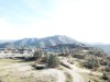
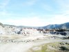
Ok was out there today, a plane did fly overhead, a cal fire water scoop drop plane. but he was high over head a good 6-7K feet at min.
Got some photos to show my location,
Got some photos to show my location,
Attachments
-
 7965154D-3249-4439-8A4B-72DAD53E63AE.jpeg4 MB · Views: 8
 -
 237956A9-D24E-4CAD-A6F0-E0C4316A14FA.jpeg4.3 MB · Views: 8
 -
 B8992A0B-41CE-4229-B069-8A77C2C43CBB.jpeg4.7 MB · Views: 8
 -
 B9033140-7CC4-45F8-9AC0-0B35782C6223.jpeg4.3 MB · Views: 8
 -
 820D45A7-0F17-4D61-8785-F481DA12E9A0.jpeg4.9 MB · Views: 8
 -
 29F84F66-5649-4808-8707-C3C49657B78C.jpeg4.2 MB · Views: 8
 -
 B8F155C7-B794-48E8-98B0-DA2C5D2ADB04.jpeg4.1 MB · Views: 8
 -
 C3E8B6BB-1625-4FD6-8FA8-076719E5AED1.jpeg4.4 MB · Views: 7
 -
 1170BB38-FB51-474D-A19A-566EDB4CEFD3.jpeg4.6 MB · Views: 7
 -
 2D6E71A8-FD5B-42F6-B089-CF958894048F.jpeg4.6 MB · Views: 5
Similar threads
- Replies
- 4
- Views
- 4K
- Replies
- 8
- Views
- 2K


DJI Drone Deals
New Threads
-

-
3 We hit another Log, also destroyed our Jib. Awesome Week
- Started by Vernon
- Replies: 0
-

-
-
Forum statistics
