DJI Mavic, Air and Mini Drones
Friendly, Helpful & Knowledgeable Community
Join Us Now

Recommendations for RTH if flying under tree cover

Siam

Well-Known Member
Joined
Aug 25, 2019
Messages
78
Reactions
97
Age
59
Location
Texas
What do you guys do when flying under tree cover and you are afraid of a loss of signal? I figure one thing to do would be to set it to land and not RTH. The other would be to maybe set the RTH altitude to be 4 feet or so and rely on the collision avoidance while it is coming back.

I am leary about setting it to land since there is a good chance it would land in the water. Here is a video example (Many places are 100 percent covered with tree branches.)

 
@Siam i always set it to hover if i am flying under trees that way you have time to react and then bring it back home
 
Based on the video, unless your referring to a different location, RTH of course needs to have open space above it, so that it can ascend to the specified RTH altitude. Even if you set RTH very low, and there are other obstacles, it would be an iffy flight and in some situations, signal loss, I think the only option is RTH and battery low, you may have some control to determine your return, if you start to recover right away and not try and push it farther.

IMHO, your best bet would be to set a RTH altitude higher than the surrounding cover, and short of signal loss, you should be able to move to a clear space to RTH, and of course the Home point should be clear and easy to land in.
 
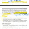
If you lose signal and you are more than 50 meters away from HP and have GPS, the M3Pro will go into Failsafe RTH and backtrack 50 meters along the original route before straight lining to Home. In those 50 meters of backtracking you should (might) regain the signal and can cancel the Failsafe RTH. I'm wondering (assuming) as it backtracks, does it also follow all altitude changes. Too much wild fire smoke here to test today, anybody tried it and know if the exact path and altitude is followed for those 50 meters?

LossOfSignal-50meters.jpg
 
Last edited:
If you lose signal and you are more than 50 meters away from HP and have GPS, the M3Pro will go into Failsafe RTH and backtrack 50 meters along the original route before straight lining to Home. In those 50 meters of backtracking you should (might) regain the signal and can cancel the Failsafe RTH. I'm wondering (assuming) as it backtracks, does it also follow all altitude changes. Too much wild fire smoke here to test today, anybody tried it and know if the exact path and altitude is followed for those 50 meters?

View attachment 154247
I saw that before on someone You Tube channel. I always take off and go to 100 feet and go out about 100 feet just out of habit now just in case that was to happen. But a good point for people that are not aware of that!.
 
@Siam i always set it to hover if i am flying under trees that way you have time to react and then bring it back home
Yes, gives YOU a chance to move and re-aquire the connection.

Leave a healthy planned return power reserve in this kind of mission, in case this happens and you need it to hover while you move closer/higher.
 
  • Like
Reactions: Siam
If you lose signal and you are more than 50 meters away from HP and have GPS, the M3Pro will go into Failsafe RTH and backtrack 50 meters along the original route before straight lining to Home. In those 50 meters of backtracking you should (might) regain the signal and can cancel the Failsafe RTH. I'm wondering (assuming) as it backtracks, does it also follow all altitude changes. Too much wild fire smoke here to test today, anybody tried it and know if the exact path and altitude is followed for those 50 meters?

View attachment 154247
Very interesting. If you manage to find a video or successfully achieve it at any point be sure to post it.
 
I saw that before on someone You Tube channel. I always take off and go to 100 feet and go out about 100 feet just out of habit now just in case that was to happen. But a good point for people that are not aware of that!.
What does that accomplish? How does it affect the lost signal RTH behavior later in the flight?

(50 meters is about 164 feet.)
 
What does that accomplish? How does it affect the lost signal RTH behavior later in the flight?

(50 meters is about 164 feet.)
I meant 100 yards and my understanding is that once the Mini 3 goes past 50 meters then if you have an RTH it will go to the altitude you specified, not the current altitude.
 
Hover.

Range through trees is so low when it loses signal you can walk to it in under a minute. Last thing you want is it trying to go somewhere.
 
Each model is different as to default altitudes for RTH. The distance from home when RTH is triggered makes a difference on what altitude is used. Check your user manual for specific details.
 
I meant 100 yards and my understanding is that once the Mini 3 goes past 50 meters then if you have an RTH it will go to the altitude you specified, not the current altitude.
Ah. Yes, that's pretty much my understanding about the Fail Safe RTH function, too. Though, if it's above the RTH altitude, it returns at that altitude rather than descending to the preset RTH altitude.

I thought you were responding to @EyesWideShut's post about the Mini 3 backtracking for 50 meters before beginning the return, and didn't see the connection.

I just read through that section of the M3P manual again. It's good to get reminded of these things when I'm switching between drone models often.
 
What do you guys do when flying under tree cover and you are afraid of a loss of signal? I figure one thing to do would be to set it to land and not RTH. The other would be to maybe set the RTH altitude to be 4 feet or so and rely on the collision avoidance while it is coming back.

I am leary about setting it to land since there is a good chance it would land in the water. Here is a video example (Many places are 100 percent covered with tree branches.)

I had two early training accidents when I first got my Mini-2(s), that involved flying under or near tree cover.

One of them was straight-up pilot error; I didn't think to look up, and clipped a low hanging branch. After enabling the upward gimbal deflection on the Mini-2, and looking up every time, the problem never recurred. But RTH wasn't involved; the drone was hard-VLOS, and barely more than 50 feet away.

The second one may have involved an unintentional RTH attempt. It was also pilot error, although the exact nature of the error is less obvious. I was flying down near the bottom of my canyon, checking out the trees and the creek. At one point, the Mini-2 started to act strangely, and ended up whacking into a tree. What I think happened is that I was so deep down in the canyon that I lost the GPS signal, which I hadn't considered, and the drone tired to RTH into a tree above it. But the data is fuzzy enough that I'm not sure.

Now, I push the boundaries of connectivity regularly, but only with an eagle-eye on both the GPS signal strength, and the RC signal strength. As I said, those were early training accidents, and the objective or training is to learn, which I most certainly did!

After that long-winded preliminary, I now set the the RTH to hover whenever I go under close trees.

Good luck!
 
  • Like
Reactions: MS Coast
Thanks for the replies. My wife and I went to Kerrville TX for the weekend and hiked the Gaualupe RIver. I did several flights and put the Mini in Hover since I was flying along the river and some places had lots of tree cover.
 
Thanks for the replies. My wife and I went to Kerrville TX for the weekend and hiked the Gaualupe RIver. I did several flights and put the Mini in Hover since I was flying along the river and some places had lots of tree cover.
Well, sounds like your anxiety was diminished some, which we can't have, so allow me to ramp it up again... 🙂

Flying over moving water, especially close to the surface (3-20') is risky, because the VPS cameras, used for positioning, can and often do get confused, causing erratic movement without any stick input. There have been several reports in this forum of crashes under these circumstances.

The old way to deal with this was to turn off VPS (older drones that use DJI GO4). Can't do that any longer.

Lazy following a little creek is some of the coolest drone video. Just be really careful, keep in mind it may go whacky on you, so EVERY MILLISECOND be constantly looking for a place to ditch it on either shore if your control gets weird.
 
  • Like
Reactions: Siam
Well, sounds like your anxiety was diminished some, which we can't have, so allow me to ramp it up again... 🙂

Flying over moving water, especially close to the surface (3-20') is risky, because the VPS cameras, used for positioning, can and often do get confused, causing erratic movement without any stick input. There have been several reports in this forum of crashes under these circumstances.

The old way to deal with this was to turn off VPS (older drones that use DJI GO4). Can't do that any longer.

Lazy following a little creek is some of the coolest drone video. Just be really careful, keep in mind it may go whacky on you, so EVERY MILLISECOND be constantly looking for a place to ditch it on either shore if your control gets weird.
I have flown real planes and paramotors....looking for an escape route has always been a priority for me LOL. Thanks for the tip on flying over water. I never heard of that issue before.
 
Flying over moving water, especially close to the surface (3-20') is risky, because the VPS cameras, used for positioning, can and often do get confused, causing erratic movement without any stick input.
I discovered that the hard way while taking pictures with my Mini over Harvie Passage in Calgary. Fortunately I'm paranoid enough about VLOS that I noticed it was drifting into the wires before it reached them and I was able to climb quickly enough to avoid losing it.
 
Lycus Tech Mavic Air 3 Case

DJI Drone Deals

New Threads

Forum statistics

Threads
131,138
Messages
1,560,273
Members
160,109
Latest member
brokerman