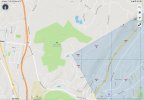
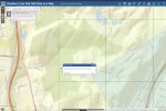
Something interesting i noticed when flying over a particular area is that the mapping is off between the FAA web site and AirMap. Pictures below. This is a pretty big difference, and it could have made a large difference. I was supposed to fly an SAR mission here the other night, and while it ended up not being needed, it raised an interesting point on how this would work.
Look at the hardscrabble wilderness area. AirMap shows none of it in the restriction zones, while FAA visualize it shows half! Photos attached. I never tried to get the authorization, and it was 1 am anyway so the airport would be closed. But it brings up an interesting problem if i ever had to fly there.
Has anyone experienced a similar situation?
Edit: i now see the difference - AirMap is only highlighting the shaded area on the FAA visualize it, while the FAA includes the entire box over that area. So who is correct here?


Last edited:


