DJI Mavic, Air and Mini Drones
Friendly, Helpful & Knowledgeable Community
Join Us Now

RTH issue

.....On Feb 3rd the RTH A....... I believe this is the record you are referring to. At ll min. and 09 sec I was at 136.2 feet and recvd. battery low msg. at 30%.
to avoid doubt can you please refer to flight by their date and time stamps as I did
 
I use airdata and I only see the file as date and time and the DJI file name does not match but I did figure out which file I was viewing and it is the 13-33-13 file
 
DJIFlightRecord_2021-02-03_[13-04-19].txt and
DJIFlightRecord_2021-02-03_[13-33-13].txt
were flown on the same switch-on of the drone. They have a common DAT number i.e. you switched the drone on then flew one flight, landed, stopped the motors and then took off again, all with out switching the drone off. The total flight time for the two flights approaches 20min+.
In DJIFlightRecord_2021-02-03_[13-04-19].txt the set RTH height was 49ft.

In DJIFlightRecord_2021-02-03_[13-33-13].txt I find the following messages,

439.6 190002=Aircraft in Warning Zone (Class D Airspace). Fly with caution).
439.9 In flight
445.1 30000010Homepoint updated. RTH altitude adjusted to 49ft)
701 HAircraft in high interference environment. Fly with caution(Code: 80015). Aircraft signal interference
704 In flight
775.5 Returning to home
779 Returning to home
794 In flight
797.2 1Low battery. Return to home promptly(Code: 30183). Low battery. 30183$Low battery. Return to home promptly)

the time stamps are lifted from the csv produced from the flight log.
If you can find others please post them.

I can see in the attached, that an RTH was initiated at 775sec and, going by a comparison with a known flight of mine, the RTH was cancelled at 791sec so it was 14secs long. During this, the distance from the home point dropped from 290ft to 80ft.
The set RTH height for the entire flight was 49ft, the flying height was 49ft and consequently did not change during the RTH.
From the csv the low battery voltage warning was issued at 797sec.

Between
DJIFlightRecord_2021-01-28_[16-30-51].txt & DJIFlightRecord_2021-01-29_[13-08-19]
the RTH height was changed from 45m/148ft to 15m/49ft.
Those two flights have the DAT file numbers 31 & 33 so there is a drone power up and switch off in between them. Whether or not there is any useful data in DAT number 32 I have no idea, there used to be RTH data in the early FLY DAT's but it seems to have disappeared somewhere around v1.0.6, that's going by my DAT's
 

Attachments

  • 07 DJIFlightRecord_2021-02-03_[13-33-13].png
    07 DJIFlightRecord_2021-02-03_[13-33-13].png
    63.3 KB · Views: 9
Last edited by a moderator:
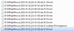
Sort the flights in chronological order earliest to latest and number them 1 to 9, the result is shown in the attachment.
Between flights 2 and 3 the drone was switched off then on and off, "on and off" created a DAT log, no 32.
Between flights 2 and 3 the RTH height was changed from 45m to 15m/49ft.
In flight 8 the RTH height was changed from 15m/49ft to 72m/236ft to 43m/141ft
 

Attachments

  • flights.png
    flights.png
    11.2 KB · Views: 6
This is how I see the events. On Jan 28th on take off the RTH Alt. was recorded at 148 feet. The flight before it on same day the recorded height was 147 feet. Why the 1 foot change? The next day, Jan 29th on take off the RTH height was recorded at 49 feet. Why the change? I did not make it. This day is also the first time I rcvd. error msgs. about the temp. being too cold to fly. I did not notice that the RTH height had changed at this time. The next important flight in trying to solve this issue is the day that I became aware of the change and when something happened that I can't explain. Feb 3rd at 1:33 flight 13-33-13 which is the flight that you analyzed and it showed low battery issue and 2 RTH initiated and a drop from 136.2 to 48.6 feet. I know everyone says if RTH is initiated at a height higher than set it will remain at that height, I even tried it and that is what happened. But I do not think that happened on the 13-33-13 flight but the records do not, as far as I can see, show who, or what, issued the command. Was it issued by the program because the battery was too low? Was there an issue with the cold? The next flight of importance is 13-42-33. I changed the RTH height to 141 feet but just one second before I made the change there was a recorded change to 236 feet, again Why that change? It's just a guess but maybe the slider bar caused this to happen, it's not too accurate so maybe when I slid it up from 49 I went too far and went to 236 and then back to 141? Would the program react so fast as to record the 236 as I paused to go back to 141? You mention that the AC was turned on and off several times but I do not see that and what does that mean? A battery change? I shut the AC off before changing a battery. What is Tripod mode? I have seen that several times. Again, thanks for all your help in trying to sort this out.
 
I read the whole manual again and I found nothing about automatic RTH dropping to a recorded height. The closest was if the battery is critically low it will land wherever it is. I believe my battery was at 30% so I don't think that was the issue. Maybe the extreme cold from 2 days prior did something. I also looked for "Tripod" mode in the manual, nothing found so I did a search in this site and found that is a term used in other Mavic drones for the C Mode in the mini. I have used this mode but very infrequently.
 
It would be helpful if you would use paragraphs, having to plough through a continuous string of text is not that easy. It would also be useful if you would identify the every flight you are refering to by either its name or the numbering scheme in post 26.
You have not provided a flight log where I can see a set RTH height of 147ft.

You provided logs for 2 flights on the 28th, for both the set RTH height was 148ft and both of these have the DAT number 31. This means the drone was not switched off between those flights, that IS NOT a problem, I numbered these flights 01 & 02 in the screen capture of post 26
Then the drone was switched off.
At some point after that it was switched on and switched off, thereby creating DAT number 32 but you have not provided a flight log that is connected with this "switch on and off".
Maybe your RTH height of "147ft" is contained within a flight log for which the DAT number 32.

The next flight that you provided a log for was on the 29th, numbered 03 in the above screen capture, the DAT number for this flight is 33 and the set RTH height was 48ft.
There is no evidence as to what made change in RTH height or when the change was made BUT.......

In all the 600+ flights/logs I have from my Mavic Mini I have seen only 1 'unexplained' significant change in set RTH height. There may or may not, have been minor unexplained changes but, if there were, they were not noticed.
All the set RTH heights I have seen have, with the exception of the one flight mentioned above, have always been in accordance with values I have set.
With regards to the one "unexplained " SIGNIFICANT change, it was made at a point in the flight where I changed the distance limit. I am quite prepared to believe that, whilst changing that distance limit, I accidentally made contact with the RTH height slider and dragged it 'up' as I moved the distance limit.

In truth I am inclined to believe that something similar has happened to you.
I loathe the FLY app's slider button method of changing height and distance limits etc. for two reasons,
1) the ease with which accidental changes can be made,
2) the difficulty in setting precise values.
It often takes me three of four attempts to set a limit even close to what I want. It would not surprise me in the least if you were experiencing similar difficulty, in fact I would be surprised if you were not.
The typing-in-numbers method of changing limits that is used in the Go Apps is IMO far, far better.

With regard to
"Feb 3rd at 1:33 flight 13-33-13 which is the flight that you analyzed and it showed low battery issue and 2 RTH initiated and a drop from 136.2 to 48.6 feet. I know everyone says if RTH is initiated at a height higher than set it will remain at that height, I even tried it and that is what happened. But I do not think that happened on the 13-33-13 flight but the records do not, as far as I can see, show who, or what, issued the command"

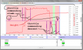
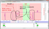
The attached show, for flight 07 DJIFlightRecord_2021-02-03_[13-33-13], the plot of height vs flight mode vs throttle command for both
a) the entire flight and for
b) what I think you 'question' with the quoted text.

The response of the drone seems appropriate to the flight mode, height AND throttle command, which means you commanded the descents highlighted in the second plot.


In short, if you think the drone etc. is changing the set RTH height via some unidentified process then I would suggest you should develop the habit of checking that height at every start up, it's good practise even with a flawless drone.
At the moment you are trying to identify a problem "after the event" when you are not even sure if there is a problem and have not been taking steps to determine whether the problem is real or imagined.

Given the complexity of these things it is one reason why I try to remember to run a video screen capture app with EVERY flight, so that I can check if I have made a mistake in settings or an accidental change. It has the added advantage that it also captures momentary warning messages.
 

Attachments

  • throttle vs height whole flight.png
    throttle vs height whole flight.png
    77.5 KB · Views: 11
  • throttle vs height questioned descent.png
    throttle vs height questioned descent.png
    71.9 KB · Views: 11
Last edited by a moderator:
  • Like
Reactions: EyesWideShut
In connection with the first 6, as I understand them the RTH height was 15m in the first 4 but in the 5th 2021-02-03_[13-42-33] it was changed @27secs to 72m and then almost immediately to 43m as shown in the attached.
For the 6th flight the RTH height was 43m.
Neither the firmware nor the App were updated in the period covered by those logs, being 1.0.244 & 1.2.1 respectively.
Which is the problematic flight?
Quick Question please ?? What are you using to Read the .TXT file?
 
CsvView. A Google of that will find it I think. I am on my phone and posting a link is 'awkward'.
 
Hmm...I used RTH the other day, something about signal interference on 5GHz only model/RC with nothing around and the app set it at 91 m instead of 91 feet...playing back shows that it went to 300ft when I hit RTH. Didn't need to go that high, but no harm done. No way in the FLY app to set the preferred measurements to use.
 

DJI Drone Deals

Forum statistics

Threads
131,088
Messages
1,559,721
Members
160,073
Latest member
testtest