It would be helpful if you would use paragraphs, having to plough through a continuous string of text is not that easy. It would also be useful if you would identify the every flight you are refering to by either its name or the numbering scheme in post 26.
You have not provided a flight log where I can see a set RTH height of 147ft.
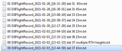
You provided logs for 2 flights on the 28th, for both the set RTH height was 148ft and both of these have the DAT number 31. This means the drone was not switched off between those flights, that IS NOT a problem, I numbered these flights 01 & 02 in the screen capture of post 26
Then the drone was switched off.
At some point after that it was switched on and switched off, thereby creating DAT number 32 but you have not provided a flight log that is connected with this "switch on and off".
Maybe your RTH height of "147ft" is contained within a flight log for which the DAT number 32.
The next flight that you provided a log for was on the 29th, numbered 03 in the above screen capture, the DAT number for this flight is 33 and the set RTH height was 48ft.
There is no evidence as to what made change in RTH height or when the change was made BUT.......
In all the 600+ flights/logs I have from my Mavic Mini I have seen only 1 'unexplained' significant change in set RTH height. There may or may not, have been minor unexplained changes but, if there were, they were not noticed.
All the set RTH heights I have seen have, with the exception of the one flight mentioned above, have always been in accordance with values I have set.
With regards to the one "unexplained " SIGNIFICANT change, it was made at a point in the flight where I changed the distance limit. I am quite prepared to believe that, whilst changing that distance limit, I accidentally made contact with the RTH height slider and dragged it 'up' as I moved the distance limit.
In truth I am inclined to believe that something similar has happened to you.
I loathe the FLY app's slider button method of changing height and distance limits etc. for two reasons,
1) the ease with which accidental changes can be made,
2) the difficulty in setting precise values.
It often takes me three of four attempts to set a limit even close to what I want. It would not surprise me in the least if you were experiencing similar difficulty, in fact I would be surprised if you were not.
The typing-in-numbers method of changing limits that is used in the Go Apps is IMO far, far better.
With regard to
"Feb 3rd at 1:33 flight 13-33-13 which is the flight that you analyzed and it showed low battery issue and 2 RTH initiated and a drop from 136.2 to 48.6 feet. I know everyone says if RTH is initiated at a height higher than set it will remain at that height, I even tried it and that is what happened. But I do not think that happened on the 13-33-13 flight but the records do not, as far as I can see, show who, or what, issued the command"
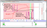
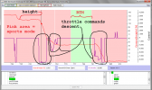
The attached show, for flight 07 DJIFlightRecord_2021-02-03_[13-33-13], the plot of height vs flight mode vs throttle command for both
a) the entire flight and for
b) what I think you 'question' with the quoted text.
The response of the drone seems appropriate to the flight mode, height AND throttle command, which means you commanded the descents highlighted in the second plot.
In short, if you think the drone etc. is changing the set RTH height via some unidentified process then I would suggest you should develop the habit of checking that height at every start up, it's good practise even with a flawless drone.
At the moment you are trying to identify a problem "after the event" when you are not even sure if there is a problem and have not been taking steps to determine whether the problem is real or imagined.
Given the complexity of these things it is one reason why I try to remember to run a video screen capture app with EVERY flight, so that I can check if I have made a mistake in settings or an accidental change. It has the added advantage that it also captures momentary warning messages.


![07 DJIFlightRecord_2021-02-03_[13-33-13].png](/data/attachments/123/123305-2ee0511b839077017aef843bab66737e.jpg?hash=LuBRG4OQdw)