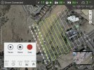
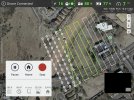
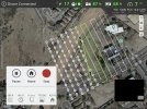
That looks like GPSTest....If you hit the "share" function and choose "device" on that popup, it'll upload some inner details on the RC Pro device capabilities. If you whizz on over immediately to the linked spreadsheet, the last row in there should be yours, if you're interested.
Also, as an aside, I went down a whole rabbit hole with this - my S21 didn't show BeiDou, despite a spec sheet that said it could. In researching why, I stumbled upon a blog by the GPSTest author who detailed a story of a user travelling from Europe to the USA, monitoring GPSTest, and suddenly seeing all the Galileo satellites disappear from the list once over the USA. Long story short, it's actually illegal in the US to receive foreign GNSS signals without a license! It appears that receiver manufacturers generally hadn't applied for the Galileo licenses. There is a waiver process for this for the GNSS, and the EU applied and ultimately got a waiver from requiring receivers to be licensed to use Galileo. On the FCC website for waivers, there is only the EU waiver; nothing for GLONASS (guessing because it pre-dated the ruling) and nothing for BeiDou. Part of me wonders if the lack of BeiDou is a chipset limitation or a license limitation.


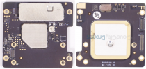
 I can't find that image online. Are there more like it of the


") I ain't touching mine either, but hopefully a "friend" can "find" one for me, per a different thread
I ain't touching mine either, but hopefully a "friend" can "find" one for me, per a different thread