You are using an out of date browser. It may not display this or other websites correctly.
You should upgrade or use an alternative browser.
You should upgrade or use an alternative browser.
The BIG GNSS (GPS) Issue -- The Constructive Thread
- Thread starter ianwood
- Start date
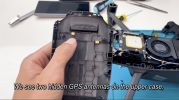
I think that, like several of us are, @ianwood is just trying to understand the GNSS system and the components that impact or influence it's performance, or could potentially impact or influence that, in both hardware and software. This knowledge could then drive testing out certain things, not just the obvious ones, leading to potentially figuring out a workaround (like "ascend 20 feet"), because DJI remain silent on everything to do with this. The proximity of other radio signals to the GNSS antenna *could* impact it's performance, sure; unlikely to be the issue, but possible.What is the significance? Could that be the problem?
johnmont250
Well-Known Member
Ian is very good at this stuff, he spearheaded diagnosis of the now famous toilet bowl effect and dji listened.
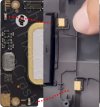
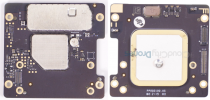
The GPS daughter board appears to have two raised contacts in the same layout/location. Roughly looks like they would connect?
View attachment 143167
Well, clearly... your picture is a lot better than mine!
Ian is very good at this stuff, he spearheaded diagnosis of the now famous toilet bowl effect and dji listened.
I just got you all you all the complain loudly! Hopefully this doesn't require such efforts!
RocketBrew
Well-Known Member
Or buy one instead of opening your aircraft!

 cloudcitydrones.com


Cloud City Drones - Professional Drones, Parts & Accessories
Cloud City Drones is your one-stop-shop for everything drone related. Shop our selection of drone payloads, accessories, repair parts, and more online.
Hahaha, for a hot and crazy minute, I did contemplate if I could open one up and tap into the GNSS chip I/O with the rest of the system, be it SPI or I2C or UART, link to a microcontroller and log some meaningful low level info in the fieldI ain't touching mine either, but hopefully a "friend" can "find" one for me, per a different thread

Attachments
-
 F7B7CFD6-969C-4D4B-AD0F-C1FC614C5A8A.png32.4 KB · Views: 18
 -
 07A7AE6E-0096-4F5D-AB63-359D0230A5B0.jpeg920.4 KB · Views: 15
 -
 0661535B-E9F6-4456-862B-084F0D2FACEF.jpeg868 KB · Views: 15
 -
 E9ECF9BC-2140-45F7-A7B0-130BD8E001D6.jpeg868.6 KB · Views: 14
 -
 3F0E5737-6C9D-45D0-ACFE-2187EE4FFFF2.jpeg871.2 KB · Views: 14
 -
 64A81367-531E-41D7-A5B5-24ACFAD7C1D8.jpeg2 MB · Views: 15
 -
 2E0E32BA-1ECD-408F-A9C4-71234D62E65C.jpeg175.4 KB · Views: 20
Hahaha, yeahOr buy one instead of opening your aircraft!
View attachment 143260
I've decided to take another approach to this which is somewhat alien to me and probably won't work - and that is, give up and wait to see what DJI says and does
While we're waiting for more news... Here's a debate we can solve:
It IS NOT based only on the number of satellites.
It IS based only on the number of satellites.
So... Who's right? Evidence preferred over opinion. It ought to be verifiable using log data.
It IS NOT based only on the number of satellites.
There's a tendency to think that GPS Health simply depends on the number of satellites, but it doesn't.
For good location data, the receiver needs a suitable number of sats and a suitable spread of sats in different parts of the sky.
It IS based only on the number of satellites.
It's based on number of satellites locked, not any of the DOP calculations.
So... Who's right? Evidence preferred over opinion. It ought to be verifiable using log data.
It needs further clarification. @Meta4 is quite correct that the accuracy of a GNSS solution depends on both number of satellites and their distribution in the sky. A dilution of precision estimate for just the satellites currently locked is a reasonable way to estimate that accuracy but that's not what the DJI GPS health value represents. GPS health is calculated from the correlation between the GPS and the IMU solutions for position. In other words it is more a measure of confidence in the fusion position solution than a measure of GPS accuracy.While we're waiting for more news... Here's a debate we can solve:
It IS NOT based only on the number of satellites.
It IS based only on the number of satellites.
So... Who's right? Evidence preferred over opinion. It ought to be verifiable using log data.
In terms of separating opinion from evidence, I can say for certain that GPS health has never been a DOP calculation - it has always been a position confidence value. For example can be zero with 20 satellites locked and a perfectly good GNSS solution if the IMU position solution diverges from the GNSS solution.
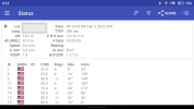
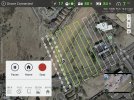
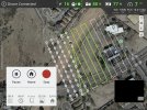
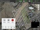
That looks like GPSTest....If you hit the "share" function and choose "device" on that popup, it'll upload some inner details on the RC Pro device capabilities. If you whizz on over immediately to the linked spreadsheet, the last row in there should be yours, if you're interested.In other news, it looks like the RC Pro is still using GLONASS and not Beidou.
View attachment 143332
View attachment 143331
Ignore the TTFF as I opened it up indoors and then took it outside. It was pretty quick once outside and probably used A-GPS. Looking for Android apps that provide detailed information about A-GPS use.
Also, as an aside, I went down a whole rabbit hole with this - my S21 didn't show BeiDou, despite a spec sheet that said it could. In researching why, I stumbled upon a blog by the GPSTest author who detailed a story of a user travelling from Europe to the USA, monitoring GPSTest, and suddenly seeing all the Galileo satellites disappear from the list once over the USA. Long story short, it's actually illegal in the US to receive foreign GNSS signals without a license! It appears that receiver manufacturers generally hadn't applied for the Galileo licenses. There is a waiver process for this for the GNSS, and the EU applied and ultimately got a waiver from requiring receivers to be licensed to use Galileo. On the FCC website for waivers, there is only the EU waiver; nothing for GLONASS (guessing because it pre-dated the ruling) and nothing for BeiDou. Part of me wonders if the lack of BeiDou is a chipset limitation or a license limitation.
Last edited:
I still think some with knowledge should check out if the agps data is transfered correctly.
There is a status message that returns the agps data from the drone.
DataFlycGetPushAgpsStatus, DataFlycSendAgpsData
Could also be nice to check that the gps har the correct time.
Does it take long for TTFF or is that fast?
If TTFF is fast, it's probably not an AGPS problem.
I don't have a mavic3 to try out, yet
RocketBrew
Well-Known Member
That looks like GPSTest....If you hit the "share" function and choose "device" on that popup, it'll upload some inner details on the RC Pro device capabilities. If you whizz on over immediately to the linked spreadsheet, the last row in there should be yours, if you're interested.
Also, as an aside, I went down a whole rabbit hole with this - my S21 didn't show BeiDou, despite a spec sheet that said it could. In researching why, I stumbled upon a blog by the GPSTest author who detailed a story of a user travelling from Europe to the USA, monitoring GPSTest, and suddenly seeing all the Galileo satellites disappear from the list once over the USA. Long story short, it's actually illegal in the US to receive foreign GNSS signals without a license! It appears that receiver manufacturers generally hadn't applied for the Galileo licenses. There is a waiver process for this for the GNSS, and the EU applied and ultimately got a waiver from requiring receivers to be licensed to use Galileo. On the FCC website for waivers, there is only the EU waiver; nothing for GLONASS (guessing because it pre-dated the ruling) and nothing for BeiDou. Part of me wonders if the lack of BeiDou is a chipset limitation or a license limitation.
China’s Rival to GPS Navigation Carries Big Risks
 www.voanews.com
All other global navigation satellite systems — GPS, GLONASS (Russia) and Galileo (EU) — mainly act as beacons, beaming out signals picked up by billions of devices using them to determine their precise position on Earth.
BeiDou is a two-way communication system, allowing it to identify the locations of receivers. BeiDou-compatible devices can transmit data back to the satellites, even in text messages of up to 1,200 Chinese characters.
"In layman's terms, you can not only know where you are through BeiDou but also tell others where you are through the system," China's state broadcaster CCTV said last month.”
M3 could be using the uBlox M8030-KT GNSS chip as it has in the Air 2 and Air 2S. It's a bit dated but still very much up to the task and there isn't any new functionality suggesting it has been upgraded.
While DJI has claimed greater positioning accuracy on the M3, there is nothing suggesting that additional accuracy is coming from increased GNSS resolution. My guess is that greater accuracy is coming from other sensors like vision and OA.
DJI has a pretty long history of carrying over chips from previous platforms e.g. P1/S1 SDR chips used for Ocusync 2 onwards.
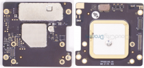
There are similarities between the Air 2S and M3 GNSS daughterboards. While I accept it's not exactly a scientific assessment, the similarity is suggestive if nothing else.
Air 2S
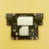
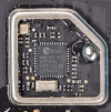
M3
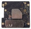
While DJI has claimed greater positioning accuracy on the M3, there is nothing suggesting that additional accuracy is coming from increased GNSS resolution. My guess is that greater accuracy is coming from other sensors like vision and OA.
DJI has a pretty long history of carrying over chips from previous platforms e.g. P1/S1 SDR chips used for Ocusync 2 onwards.
There are similarities between the Air 2S and M3 GNSS daughterboards. While I accept it's not exactly a scientific assessment, the similarity is suggestive if nothing else.
Air 2S


M3

BeiDou is a two-way communication system, allowing it to identify the locations of receivers. BeiDou-compatible devices can transmit data back to the satellites, even in text messages of up to 1,200 Chinese characters.
It's an interesting capability and one with obvious security concerns but as I understand it, the vast majority of Beidou receivers are receive-only and cannot transmit. I am first to admit my limited understanding here, but I would have thought TX ability would require amplification circuits and a high gain antenna to get the signal all the way back into space.
I still think some with knowledge should check out if the agps data is transfered correctly.
There is a status message that returns the agps data from the drone.
DataFlycGetPushAgpsStatus, DataFlycSendAgpsData
Could also be nice to check that the gps har the correct time.
Are these status messages that appear in log files? If so, I can pull some from cold and warm starts to analyze.
Good question. I don't think so, not sure though.Are these status messages that appear in log files? If so, I can pull some from cold and warm starts to analyze.
What would be intersting is how long time it takes for it reports at least 1sat from startup. That would give a clue.
It's quite hard to do if you havn't done it before. I have an app that can do it, however I don't dare to give it away until I tested it myself on mavic3. My FPV-drone went bananas when doing something similar, fixable though.
Similar threads
- Replies
- 8
- Views
- 2K
- Replies
- 24
- Views
- 3K
DJI Drone Deals
New Threads
-
Simulators with the DJI RC N1 controller.....
- Started by Dan'sUavTech
- Replies: 0
-
-
UAS Nexus (By Chris 'The Drone Geek' Fravel)
- Started by The Droning Company
- Replies: 0
-
A Guide to Posting Drone Footage on Social Media.
- Started by The Droning Company
- Replies: 0
-
Members online
Total: 5,103 (members: 9, guests: 5,094)


