@WMartz
Bill - Did you ever reach more of an understanding of what might have gone wrong here?
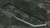
I have run some checks on your mission and it looks to me as if the altitude used for WP4 was actually 100' rather than the 300' which I see published on Mission Hub and the altitude for WP5 was 50' rather than the published 300'
Is that possible? Were you perhaps modifying some WP parameters prior to take-off and did not save the modified mission to the Mission Hub?
Have you tried VLM? It's great for checking out your missions before you fly and will help avoid expensive accidents like this!!
N