DJI Mavic, Air and Mini Drones
Friendly, Helpful & Knowledgeable Community
Join Us Now

Unlawful use of a drone to capture video of killer whales.

Done that once What a place! didnt have a problem Flying. The people at Pebble beach wouldnt let me go out and hit just one ball tho...I wanted to be able to say I played at Pebble beach ! lol (Without spending the oodles of money)!! They didnt let me Fly either I asked. Don't Fly at pebble beach they will shoo you away nicely. lol
 
Done that once What a place! didnt have a problem Flying. The people at Pebble beach wouldnt let me go out and hit just one ball tho...I wanted to be able to say I played at Pebble beach ! lol (Without spending the oodles of money)!! They didnt let me Fly either I asked. Don't Fly at pebble beach they will shoo you away nicely. lol

Cool!

Unless golf courses are your thing, everything around PB is where the gold is in terms of imagery. Did you fly an FPV drone?

Also, drop me a PM if you're coming up this way, I'd love to get together for some flying, and a few beers – in that order 😁

In fact, I highly recommend an afternoon of flying at Asilomar, then dinner at Sapporo, a Teppanyaki Hibachi-style restaurant like Benihana, but cheaper and just as good.
 
  • Like
Reactions: Cafguy
love to sometime Perhaps after I put back the cash I m about to spend on Drones lol. I had My Air2S and I asked the same guy about the Drone when I asked about the Free drive. lol Im not much of a golfer I do live next to one tho they have no problems letting me fly my Drones there as long as they are not busy. (Not many golfers use this one) The Hospital killed the Big stuff Flying last summer when they stuck in a new Heliport thing down the road for Cal Fire.
 
Golf Course photos? Meh.

FPV the Avata 2 all around a GC? Now that's something I'd like to do some time 👍🏻

re: Cal Fire... Are you in restricted airspace now, or just a warning zone?
 
  • Like
Reactions: Cafguy
Just a warning zone I am less than 6 miles away I am also 7 miles away from the Bakersfield Airport and right on the ILS approach. The planes are 1500 ft above me at times We have a radio tower nearby that keeps the aircraft at at least 1500. I have gotten permission to fly in my area lots of times in the past But now... to much heli traffic at times to even try. BUT I can drive right down the street with my buddies to a place with more swing sets and stuff lol and be in the clear. So not really worth all the permissions stuff... besides I mainly fly tiny whoops around here- 70 grams or less 1c battery types SO not a big hassle
 
The federal agency is warning drone operators (Not at all...)
I cannot but wonder why folks read some Internet "news" article and take it for granted that it is true and accurate… Why? My guess is that the article was "AI" (Always Inaccurate…) generated…

If the OP had only done just a "tinsey bit" of googling, they would have found out that at the very least, the "304 Meter" reference was completely inaccurate…

 
  • Like
Reactions: Cafguy
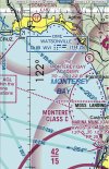
OK, so I have a question - There’s a blue dotted line along most of the coastline, it even extends between the pier in Santa Cruz past Palm Beach:

IMG_2539.jpeg


Based on the chart symbol key here (See “wildlife, and recreational area depiction” figures 2 and 3), it’s depicted as having a minimum altitude for flyover requested to be 2000’ AGL.

Is this the correct meaning of that blue dotted line?
 
Last edited by a moderator:
I cannot but wonder why folks read some Internet "news" article and take it for granted that it is true and accurate… Why? My guess is that the article was "AI" (Always Inaccurate…) generated…

If the OP had only done just a "tinsey bit" of googling, they would have found out that at the very least, the "304 Meter" reference was completely inaccurate…

Did you read this:
"

Viewing marine mammals from the air​

The noise and presence of aircraft (including drones) can disturb wildlife both in the water or on land.

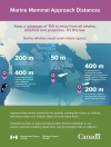
When an aircraft is being operated at an altitude of less than 304.8 metres (1,000 feet) within a radius of one-half nautical mile from a marine mammal, it cannot perform a flight manoeuvre. A flight manoeuvre includes taking-off, landing or altering the course or altitude of the aircraft. This is to prohibit the purpose of bringing the aircraft closer to the marine mammal or otherwise disturbing it.

Drones are discouraged for viewing marine mammals unless appropriate permits are obtained. For more information on licensing and permitting, please visit: Application instructions for the authorization of marine mammal disturbance."
1724369437841.png
 
I cannot but wonder why folks read some Internet "news" article and take it for granted that it is true and accurate… Why? My guess is that the article was "AI" (Always Inaccurate…) generated…

If the OP had only done just a "tinsey bit" of googling, they would have found out that at the very least, the "304 Meter" reference was completely inaccurate…

I checked it. It's accurate. 304.8 metres is 1,000 feet, that is the altitude separation between aircraft and marine mammals set out in s. 7.2 of the MMR. The vertical separation is given as half a nautical mile. Ironically, for aircraft they base the separation distances on imperial units, but not for vessels (from which the "nautical" part of nautical miles comes from obviously).

That link you posted is only discussing vessel separation.

Always look at the legal reference, not the government fact sheets or summaries which often leave out key info.
 
I checked it. It's accurate. 304.8 metres is 1,000 feet,
It is the reference to "304.8 meters" that reduces the validity of this reference. None of the legal references is a distance like this mentioned, only in these "news articles." I would sooner believe Ms. Elizabeth Klarer was abducted by space aliens than articles where the "writer" (human or AI…) uses "off-the-wall" adjustments to facts to sensationalize the content…

Since the article about Elizabeth Klarer is in Wikipedia, you can trust it… L 🤣 L . . .

 
A few more "findings" as I look in to this...

This area along the coast from Santa Cruz to Pescadero, is absolutely spectacular imagery. Most of this coastline is rugged, eroded vertical cliffs, with agriculture, forests, and coastal mountains rising about 2000yds inland.

Spectacular place to fly and capture some great images.

And the good news is, you can fly here, even with the Marine Sanctuary.

The boundary of that, and the other NOAA sanctuaries is defined in Appendix B to Subpart M of Part 922 for the Monterey Sanctuary. It is defined as follows:

"From mean high water to 3 nautical miles (nmi) offshore between a line extending from Point Santa Cruz on a southwesterly bearing of 220° true and a line extending from 2.0 nmi north of Pescadero Point on a southwesterly bearing of 240° true;"​
They key words here are, "mean high water"... This essentially means you're legal to fly right up to the cliff edge, just don't go past.

There is plenty of great, fun flying and imagery to capture under those constraints along the coast between Santa Cruz and Pescadero.
 
  • Like
Reactions: LoudThunder
We have those same laws in Florida but often dolphins and manatees pop up underneath my drone when I'm flying over local waters, especially when murky. I fly away from them but miss out on some awesome closeups that could eventually get me arrested. I never get away with anything.
Can you give me a pointer to those Florida laws please.
 
  • Like
Reactions: LoudThunder
To view this content we will need your consent to set third party cookies.
For more detailed information, see our cookies page.

If you scroll through my video taken on the river Thames I purposely hovered an Air3 10 feet above a group of Geese ! You will see in the video that not one even noticed the drone !
To claim a tiny silent Drone is going to somehow effect massive Orcas is Ridiculous ! If someone on s bost films them with an zi phone thats Ok ???
This is beyond ridiculous
It is what it is... many things don't make sense or close to being proportionate, but there you have it.
 
To view this content we will need your consent to set third party cookies.
For more detailed information, see our cookies page.

If you scroll through my video taken on the river Thames I purposely hovered an Air3 10 feet above a group of Geese ! You will see in the video that not one even noticed the drone !
To claim a tiny silent Drone is going to somehow effect massive Orcas is Ridiculous ! If someone on s bost films them with an zi phone thats Ok ???
This is beyond ridiculous
Perhaps geese are more accustomed to flying things whereas orcas are not. I can only presume the rules are meant to keep people from approaching too closely and getting into a position where the animals would be spooked. Stressed aquatic creatures have a nasty habit of beaching themselves, which is also probably why a lot of these areas are closer to shore. But I'm not a Dept. of Fisheries officer, so I have no idea.
 
I cannot but wonder why folks read some Internet "news" article and take it for granted that it is true and accurate… Why? My guess is that the article was "AI" (Always Inaccurate…) generated…

If the OP had only done just a "tinsey bit" of googling, they would have found out that at the very least, the "304 Meter" reference was completely inaccurate…
There was nothing inaccurate about the article.
It is the reference to "304.8 meters" that reduces the validity of this reference.
Since Canada (like almost all countries) uses the metric system, it's quite normal for a journalist to convert a measurement in feet to metric.
That doesn't do anything to reduce the validity of the article.
 

DJI Drone Deals

New Threads

Forum statistics

Threads
135,143
Messages
1,602,946
Members
163,634
Latest member
Suhail78
Want to Remove this Ad? Simply login or create a free account