- Joined
- Feb 27, 2019
- Messages
- 36
- Reactions
- 24
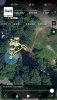
How can I take the satellite view showing the flight data and path from the flight list so that I can sync it with the actual video taken during the flight as a picture within the picture. I want to show the flight data and warning messages as they occurred during the flight. .
This particular flight was somewhat dramatic with "low battery, RTH" over a waterfall and dense forest.

This particular flight was somewhat dramatic with "low battery, RTH" over a waterfall and dense forest.