DJI Mavic, Air and Mini Drones
Friendly, Helpful & Knowledgeable Community
Join Us Now

Waypoint mission problem

If so why not raise the programmed height accordingly?
I do after the fact obviously. But it shouldn't do that in the first place. I would say the reason that the other people have not noticed this, is because they're not flying Waypoint Mission very much.
Since I have had two separate mavic 3's that did this, I know it's a problem in all mavic 3's. I didn't post this expecting any help. I posted it to inform other people of this problem.
 
I do after the fact obviously.
"After the fact" isn't much use, especially if your drone has crashed, nor is what you have done obvious.
I know it's a problem in all mavic 3's.
How do you know, where are the links to appropriate articles/threads?

"I posted it to inform other people of this problem."
They might be better served if you flew a demonstration flight and posted the log and, if possible, the waypoint flight plan.
 
"After the fact" isn't much use, especially if your drone has crashed, nor is what you have done obvious.

How do you know, where are the links to appropriate articles/threads?

"I posted it to inform other people of this problem."
They might be better served if you flew a demonstration flight and posted the log and, if possible, the waypoint flight plan.
Look, the waypoint software doesn't work properly. Can't you understand that? Why don't you buy a mavic 3 and try it yourself.
 
I just got this email from DJI. They still want to ignore the fact that there's a defect in their software. How dumb can you get.

Dear Steven,

Thank you for getting back to DJI North America Technical Support.

We can totally understand how you feel and we take this very seriously, the accident may be caused by the disability of the obstacle avoidance system while flying or the mis operation by the pilot, since the drone hit a tree, to ensure a safe flight, it is highly recommended to send it back to DJI for inspection, DJI will provide free data analysis for this accident, if the result shows it is non-user responsibility, DJI will provide free service to you.

Regarding the software, as a customer service representative, we may not be professional as our engineers to answer this question, but once the unit is sent back to our service center, our well-trained engineers will be able to perform a full inspection on it and carry out the reasonable solution to you, rest assured that all the issue will be resolved in the end and we have been working to meet your requirements and satisfaction.

Should you have any other questions, please feel free to contact us.
Thank you for choosing DJI.
Best Regards,
Fred

BTW, there's no was to disable obstacle avoidance during a waypoint mission. Don't they even know that? Misoperation? If the waypoints go from 200 feet to 100 feet, and the drone ends up going to 50 feet, that's misoperation?
 
Can't you understand that? Why don't you buy a mavic 3 and try it yourself.
I can understand plenty.
Why don't you fly a flight, within control range, to demonstrate the problem, post the flight log and, if possible, the flight plan so that we can see your 'evidence'?
I won't buy a Mavi 3 of any sort because I don't want one, I am satisfied with the drones I have. Besides I have no desire to fly a waypoint flight. Some of my drones do, I think, offer the option but I prefer to be in command of the drone.
 
That doesn't explain anything in my case. I've already does all this stuff. Fly automatically updates google maps, right?
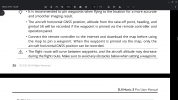
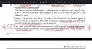
The screenshot of the Mavic 3 Pro User Manual very clearly warns that the aircraft altitude may decrease during the flight route of a Waypoint mission, and that only the horizontal GNSS position can be recorded when the waypoint is pinned via the map, instead of actually flying the mission to record it, which is the DJI recommended method for greater accuracy.

Not sure what you mean by "Fly automatically updates Google Maps."
Google Maps are not used by Fly, and Fly certainly cannot update the maps of any map provider, and maps are only as good as the last map update, which may be years ago, which is why relying upon them is not recommended, and manually flying the route first is the recommended method.

Obviously, if you are programming waypoints beyond the signal range of the remote in areas in foreign countries you have never been to, you are going to have problems. That doesn’t make DJI stupid. Some would say you are being reckless. Hard to disagree with them!


IMG_4755.jpeg
 
That said, if it is such a common occurrence that " .... has a problem when you go from a higher altitude to a lower altitude, it always overshoots the lower altitude by a large margin." is applicable, I would have thought that others would have encountered the problem and that there would other threads about it, I do not recollect seeing any.
Have you seen any such threads? If so could you post links to them, they'd be an interesting read and might contain logs and flight plans.
That said it has just come to mind that there was one possible related thread where a drone, type not remembered, might have overshot a lower altitude. I think the flight was around what the British would call a "Stately Home" but the flight was possibly in Europe and the overshoot, if it was an overshoot, was over water, a lake or river. Obviously I don't remember all the details so I can not say this was a Mavic 3 or even if it was a Fly App flight.

Since "the Mavic 3" or perhaps 'your Mavic 3' "always" descends below the programmed height have you spotted a pattern to the amount by which it "overshoots"?

New thread posted yesterday seemingly confirms a 50 foot drop in elevation without any stick input, with a log file.

 
How am I gonna manually fly a route that's way out of signal range? Sometimes I wonder about you guys!
Clearly you can't, which is why you are having problems!
Is that your only response to my post above, corroborating the on point warnings from DJI in the User Manual that you are ignoring?
 
I can understand plenty.
Why don't you fly a flight, within control range, to demonstrate the problem, post the flight log and, if possible, the flight plan so that we can see your 'evidence'?
I won't buy a Mavi 3 of any sort because I don't want one, I am satisfied with the drones I have. Besides I have no desire to fly a waypoint flight. Some of my drones do, I think, offer the option but I prefer to be in command of the drone.
I've already reported this to DJI with a picture of the waypoint mission, and they did nothing. They are the only ones who can fix this problem.
Unfortunately, when I had to clear space on my internal memory, I accidentally deleted all my waypoint missions prior to my se asia trip.
 
Clearly you can't, which is why you are having problems!
Is that your only response to my post above, corroborating the on point warnings from DJI in the User Manual that you are ignoring?
DJI is talking about the waypoint missions you make during flight. I make all my missions at home not connected to the drone. If it's not using google maps, why does it say google on the map?

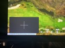
See the little google in the lower left corner. If you have the google map app on your phone, you should know google automatically updates it. Same with the one Fly uses.
Screenshot_20230605-175247.jpg
 
Last edited:
I do after the fact obviously. But it shouldn't do that in the first place. I would say the reason that the other people have not noticed this, is because they're not flying Waypoint Mission very much.
Since I have had two separate mavic 3's that did this, I know it's a problem in all mavic 3's. I didn't post this expecting any help. I posted it to inform other people of this problem.
I can give you a few reasons why I cannot depend on the Motion Sensors on the drones there not full proof ,, but there not a gimmick either but If I want them to Fail I just need to increase my speed .

If you were to use some of the other more Expensive Software , you also will see ways to make your Missions fail , and there is no FIX coming anytime soon from them or DJI as so much of the New Technology will fail as we increase speed an or precise breaking . I do not believe its the Software as Much as the Chip ability to Calculate fast enough.

I think its a Great you pointed this out, as I do think it can trip up a lot of New Pilots as well as relying on the sensors.

Phantomrain.org
Gear to fly in the Rain. Land on the Water.
 
Last edited:
Unfortunately, when I had to clear space on my internal memory, I accidentally deleted all my waypoint missions prior to my se asia trip.
I repeat.
"Why don't you fly a flight, within control range, to demonstrate the problem, post the flight log and, if possible, the flight plan so that we can see your 'evidence'?"
As for BKusher's problem that was a manual flight not involving waypoints, as I understand your complaint/claim, you were are complaining that a descent as part of a waypoint flight had an unreliable endpoint.
Where as BKushers problem concerns an uncommon descent in a manual flight. To me the two seem somewhat disconnected.
 
DJI is talking about the waypoint missions you make during flight. I make all my missions at home not connected to the drone. If it's not using google maps, why does it say google on the map?

See the little google in the lower left corner. If you have the google map app on your phone, you should know google automatically updates it. Same with the one Fly uses.
View attachment 164918
Actually, the User Manual screenshot I highlighted in red above talks about both types of waypoint created missions, and why flying to the waypoints is the recommended method among the two, and exactly why your method has problems.

DJI Fly on both the RC Pro and the DJI RC does not use Google Maps.
DJI uses Maptiler and OpenStreetMap contributors on their own devices.
These maps are notoriously outdated and low resolution.
DJI Fly on iOS also does not use Google Maps.
There is no map copyright attribution, so it isn't Google.
You must be using an Android phone.
The maps on any device are only as good as the last map update, and not every area of the world is updated on the same schedule.
IMG_4758.jpeg
 
I repeat.
"Why don't you fly a flight, within control range, to demonstrate the problem, post the flight log and, if possible, the flight plan so that we can see your 'evidence'?"
As for BKusher's problem that was a manual flight not involving waypoints, as I understand your complaint/claim, you were are complaining that a descent as part of a waypoint flight had an unreliable endpoint.
Where as BKushers problem concerns an uncommon descent in a manual flight. To me the two seem somewhat disconnected.
Both involve unexpected descent of 50 feet. If it can happen in manual flight without stick input, it could then potentially happen in a Waypoint Mission under automated control. Whether they are related and due to a common cause within the flight controller remains to be seen.
 
  • Like
Reactions: sbunting
Both involve unexpected descent of 50 feet. If it can happen in manual flight without stick input, it can happen in a Waypoint Mission under automated control.
Until there is a proven connection I would be inclined to treat them as separate problems, besides BKushner supports his problem with evidence.
 
Lycus Tech Mavic Air 3 Case

DJI Drone Deals

New Threads

Forum statistics

Threads
130,976
Messages
1,558,496
Members
159,964
Latest member
swigmofa