DJI Mavic, Air and Mini Drones
Friendly, Helpful & Knowledgeable Community
Join Us Now

Website for displaying your panoramas

Would you like the ability to upload your panoramas and see them on a google map?

  • Yes

    Votes: 4 100.0%
  • No

    Votes: 0 0.0%

  • Total voters
    4

VintageSlots

Well-Known Member
Joined
Nov 20, 2016
Messages
89
Reactions
34
Age
64
One of the problems with panos is that while they are way cool (in my opinion) most pilots don't have a mechanism to show them off on the web.

I have developed a website that works with google earth. A marker is shown everywhere a pano has been shot.

I am thinking about opening this up to allow people to upload their own panos. Each person would get a unique ID and I am thinking it would be neat to have filters so people could see only their panos or panos from everyone. I also have some other ideas.

If you want to see a simple demonstration go to Panoverse Panos

You can zoom in on the map to see where the panos were shot and if you click on the red marker the pano will be shown.

If there is enough interest I might be looking for people to add their panos via a simple upload page I have developed.

For all I know someone has already done this. If so, please let me know.

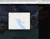
Below is a screen shot showing the map of the US with the pano markers.Screen Shot 2018-06-17 at 4.11.12 PM.png and also a screenshot of an abandoned mine building in Colorado.

Screen Shot 2018-06-17 at 4.32.59 PM.png
Thanks
 
Last edited:
Good idea but given that's already feasible in GM what's the value-add?

And some tech feedback; I'm on an Android 7 phone and the pan function doesn't work. If I move my finger around in the screen the picture twitches a bit but doesn't pan. There's more visible in landscape obviously but same problem.
 
I am an IOS guy but I know some people with android phones who have gone to the site and they have not had any issues. The site should detect that you are on a mobile device and when you tap on a marker it should bring up a separate browser window showing just the pano.

In reality, this web site is really best used on a device with a bigger screen (tablet / notebook or desktop computer).

What is GM?
 
Google Maps, but of course I meant Google Earth didn't I! Duh. I'll try it again and see where I get.

Ok, so I am officially confused.

If you shoot a pano and want to show it to other people That are not physically at your side then how do you do it?
 
Ok so I played a bit more - same problem to start with and it's clear now that even in landscape it's not showing the full Pano. I tapped the full screen icon at top right and there was no change. Try moving around the pano with a finger didn't work, it just twitched.

But what I do see now is that if I hold the phone vertically and move it around as if I were panning a video shot, it scans the pano one end to the other as if you're looking realtime. Is that the intention?
 
Ok, so I am officially confused.

If you shoot a pano and want to show it to other people That are not physically at your side then how do you do it?

You upload it to Google Earth like a normal photo, they approve it, recognise it's a panorama photo so format it accordingly and it gets tagged for the whole world to see as a pano. Were you not aware of that?

Just Google "panoramic images Google maps".
 
Ok so I played a bit more - same problem to start with and it's clear now that even in landscape it's not showing the full Pano. I tapped the full screen icon at top right and there was no change. Try moving around the pano with a finger didn't work, it just twitched.

But what I do see now is that if I hold the phone vertically and move it around as if I were panning a video shot, it scans the pano one end to the other as if you're looking realtime. Is that the intention?

Yes, that is the intention. You should also be able to use your fingers to move the pano around as well as zoom in and out.
 
You upload it to Google Earth like a normal photo, they approve it, recognise it's a panorama photo so format it accordingly and it gets tagged for the whole world to see as a pano. Were you not aware of that?

Just Google "panoramic images Google maps".
No, I was not aware of that. I will look into it. I sure don’t want to reinvent the wheel.

Thanks
 
  • Like
Reactions: Thwyllo
I didn't mean to pi$$ on your parade? If you want to share panos outside the public domain it's a good idea, but I'm not sure why you would most of the time? The Google earth thing has been around for ages.

But it needs some work on the Android platform for sure. Good luck with things.
 
No worries at all. I sure don't want to reinvent the wheel. I need to look at goggle and see what they are doing. Worst case is that I will use it for just my panos.

Androids can be a bit of a PIA with all the different HW platforms out there.
 
I can imagine; every manufacturer has their own flavour of it of course, unlike iOS, but then you're stuck with just one manufacturer of course that takes massive advantage of that fact.
 
Hey mate (OP),
There is another guy that has been working on this for a while I think? Search for Paul's pano's or similar?? He was going through it on the DJI forum.
 
For information, there is a limit on panos on Google if that affects your consideration whether it's worth continuing. I believe it's a cap of 75mb and 100mp, so if your intent is to allow bigger files that that then it's something to think about. Then again you might find your website hosting costs go up because of people opening or downloading larger file sizes.
 
If the photo is geolocalized then it tells you where it was taken and shows a map with it. It does not show a map with all photos like OP is after.
 

Attachments

  • Clipboard01.jpg
    Clipboard01.jpg
    212.6 KB · Views: 2
  • Like
Reactions: Ping^Spike
If the photo is geolocalized then it tells you where it was taken and shows a map with it. It does not show a map with all photos like OP is after.

One of the things I would require is that the photos be geotagged so the system can automatically place the marker in the correct location on the map.
 

DJI Drone Deals

New Threads

Forum statistics

Threads
130,585
Messages
1,554,117
Members
159,590
Latest member
Philip Chura