

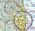
I haven't done my research about flying near small airports. Maps only show the airport, but it has no circle or altitude restriction squares near it on those maps. All I have done so far, is use LAANC to get cleared to fly across the blue landing and take off strip on the map every 2 days or so. I was flying across the zone so often at one point, that I had DJI clear the Geo zone for me for one year.

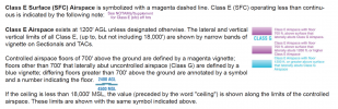
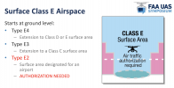
What are the rules for flying near a small, untowered, small aircraft, municipal airport with no circle or altitude squares mapped around it.
- Thread starter StevenBrodsky
- Start date

Similar threads


DJI Drone Deals
New Threads
-
-
-
-
-
 Activation code to enable drone after TRUST completion
- Started by Droning on and on...
- Replies: 4
Forum statistics
