DJI Mavic, Air and Mini Drones
Friendly, Helpful & Knowledgeable Community
Join Us Now

No fly zone around small local airport

Sang82

Member
Joined
Sep 14, 2022
Messages
8
Reactions
1
Age
41
Location
Hampshire, UK
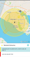
Can someone please help I have two apps altitude angel by nats and drone assist
A5F9D744-7324-486F-82A6-7FC267EED732.jpeg
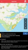
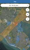
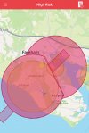
The altitude angel shows a huge no fly zone around a small local airport blocking out a much bigger area as a no fly. But the drone assist and also the Dji fly app only show a runway strip. Which one is correct?
Area Gosport Hampshire UK
7B72F114-DAE1-4E60-A60C-79B17ED19C16.jpeg
7067AE11-7E9D-4251-8AEE-9F1E6B485BE7.jpeg
 
I looked at AIRMAP and it shows both, two different zones that overlap each other.

Screenshot_20220914-040030.png

.
 
So what part of it do you think you’re not allowed to fly in? Just the inner circle or both? As the outside one is yellow. I take it the runway strip on the Dji app is incorrect?
 
Lee On Solent was a military airport upto 1996 so perhaps one map is based on old information. In general though there are many military bases in this area including of course Portsmouth harbour, so I expect there will be many restrictions.
 
  • Like
Reactions: MA2 317
What does the Fly app say when you go to fly?
When I tried to fly at Sandy Park stadium in Exeter, I had to get a code from Exeter Airport I think before I could fly. Had to enter my mobile number and was sent a code to enter into the Fly app to unlock it. After the, no problem.
 
Yes I think your correct I’m going to stick with the NATs drone assist app as it shows not only that site with airport restrictions as it now flys spitfires in and out everyday it also shows the military bases that you aren’t allowed to fly over. The Dji app isn’t very accurate of where you can or can’t fly. 34E037FA-7A4F-4192-946D-2D993254D7B8.jpeg
 
  • Like
Reactions: MA2 317
the Dji fly app only show a runway strip.
DJI isn't very good with legal restrictions. I think they have an algorithm they apply based on airport runways and don't actually attempt to include any legal aspects at all.

In Canada the DJI Fly won't stop me flying in prohibited zones. Best not to rely on it. I only worry about it because there are times when I need to get unlock codes to fly in airspace that is perfectly legal. I always check the NavCan map when planning flights to ensure I'm flying legally.

The Altitude Angel site looks good. I notice that it also includes NOTAMs, which is important.
 
  • Like
Reactions: MA2 317
US based: Use Aloft app to determine the FAA parameters as they are the entity that defines the legality of airspace operations.

A great video (Pilot Institute) for referencing this issue:

Sometimes you need a LAANC, sometimes a DJI authorization, sometimes both. If your mission area isn't available through LAANC (Aloft app, formerly Kittyhawk) you can submit a written authorization request through FAA Dronezone. I just had to do this last week and approval was granted in about 24 hours. You'll need a DroneZone account. Stay legal and fly safe.
 
  • Like
Reactions: Aerophile
Lee on Solent is now called Solent airport. It's a busy airfield, particularly at weekends, for small aircraft. ATC are most helpful. I needed to fly in their FRZ for a job. I contacted them and was told exactly what I needed to do to get permission to fly. They emailed me the form, which I filled in and emailed back. 20mins later had had my authorisation in writing from them.
You've also got the Royal Navy at RNAY Fleetlands in Gosport. They're also very helpful.
 
On class C I see 400ft blocks. But other than having a nice outline to compare against the sectionals, I'm not sure if this is redundant as we can't go above 400 anyway. Class D goes up to 200 foot blocks and doesn't bother with 300 or 400 blocks.
 
Lycus Tech Mavic Air 3 Case

DJI Drone Deals

New Threads

Forum statistics

Threads
130,600
Messages
1,554,279
Members
159,607
Latest member
Schmidteh121