DJI Mavic, Air and Mini Drones
Friendly, Helpful & Knowledgeable Community
Join Us Now

Whats the highest you've taken your Mavic?

465 feet by accident while I was making a big sweeping turn. Was at 400 feet turning and didn't realize I was also slightly climbing. Came back down to 400 quickly. :)

Sent from my SM-N920P using MavicPilots mobile app
 
  • Like
Reactions: Ez_Thug
Please don't take my post as being the drone police , lol . I was just stating that you could set a warning and limit for altitude since you said you hadn't noticed that you were that high . Also that wind conditions can be drastically different at higher altitudes than at ground level and the Mavic can get in trouble quick if you're not paying close attention to what it is doing up there . Lots of people get at high altitude and don't look at the distance display to realize it is getting away faster than it could ever make it back . You are right though that flying over 500' I'd say , doesn't really get you much more payback for the risk .

On a side note , I have about 8 acres outside of town that I have been clearing of trees and building a pond over the last two years in prep to build a new house soon . Directly overhead I see commercial airliners at 15-30,000' everyday , a private plane every now and then at 3-5000' and there is a Air ambulance heli that skirts the property pretty regular at about 1500' . The heli pad and local small airport is 4.8 miles away by air and I am parallel to the runway behind the tallest mountain in our area . I feel confident that any full size aircraft on my side of the mountain would be well above what I fly at or be in serious trouble anyway . With that being said , this past summer I was on the tractor using the back hoe when something sounded like a train not far off so I stood up in the seat to see what the heck was making that noise when a Military Osprey flew directly over the tractor at what I'd guess was 500' ! I could see the writing on the fuselage as he was in transition from forward flight to hover mode . The props stirred up dust around my tractor . I actually wished I had been flying my Yuneec 500 at that time as it would have been cool as **** . You never know what is going to happen :)

I didn't at all. No worries.

I don't have anything for airports too close by. The nearest one is probably about 25 miles the way the drone flies. Every now and again you will see a helicopter land at a school behind my house but thats maybe twice a year, if that.

Around here if you're flying and a helicopter (police) comes near they will initially slam your drone to the ground. So best practice would be to immediately land your drone if you hear one in the distance.
 
I normally stay below 400ft. But I have taken it over 1000ft about 10 times or so to film above some low laying fog in my area. I'm not in any flight paths for scheduled flights, but I do keep my eye out for anything around. Highest so far is 1350ft. As long as the wind isn't too strong the Mavic seems to handle it just fine. I also notice that going through the fog at about 600-800 ft, I will get high-wind warnings, but once i'm over the fog, the warnings go away and shes steady as a rock.
seen here!:

Pretty cool but that looks more like clouds than fog!!!


Sent from my iPhone using MavicPilots
 
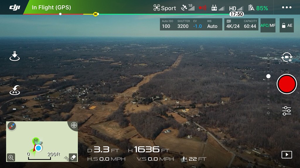
So I was planning to take a long flight over to the marina today to capture some footage over there again. I took the Mavic to about 300' and played with the gimbal a little (i was having problems with it yesterday and wanted to ensure my fix was truly a fix). I then pinned down the throttle.

I wasn't giving my phone screen dedicated attention as my dog was chasing birds around the yard and I thought it would have been funny to of filmed that. A minute or so later I look down at my remote and think "weird... It's not reading speed. Weird... It doesn't look like it is going very fast on the screen either. ****! wrong joystick pinned down." I look at my altitude and i'm at just over 1000'. So now I'm like... Holy **** batman, I'm high. Then as I feel my palms start to sweat, the child of Mossburg's past comes back and I say... "**** it, i'm already up here." and pin it down. The result is below. I brought it back after this. I got some cool video but i'll have to upload that later.

Untitled by Chris Mossburg, on Flickr


How the heck do you get a picture like this with all the data on it?? Is it recorded somewhere like that or did you use a second camera to snap the pic??
Please let me know. Thanks
 
How the heck do you get a picture like this with all the data on it?? Is it recorded somewhere like that or did you use a second camera to snap the pic??
Please let me know. Thanks
Could probably just take a screenshot. Hit home+power button at the same time and it'll take a screenshot (assuming iOS device)

For Android there are true screen recording options that Apple doesn't seem to allow.
 
  • Like
Reactions: Ez_Thug
393' is the highest mine will go. I never changed the original settings for height. I'm not willing to loose my license to find out how high it can go.
 
400ft.

Won't even go that high anymore having now taken a theory for my PfCO.
Always keep it in line of sight.
Keep it safe.

Sent from my SM-G850F using MavicPilots mobile app
 
  • Like
Reactions: Ez_Thug
I understand after reading a lot on here about maximum altitudes that there are a lot of concerns when going that high (both safety and the mavic itself). This was one of those things were I was up there and said **** with it. Already here why not see what it looks like a few hundred feet higher.

I might add that I don't have any near by airports and there is little to no air traffic around me. Every once in awhile we will see or hear a helicopter but its very few and far between. The odds of a collision with another manned aircraft is there probably similar to my odds of winning the power ball this week. That being said, the footage from that high is so far away there really isn't much to be gained so I don't see me going that high again.

At 400' I can still run in to potential of colliding with tree's, etc. just due to the fact that I am by the water and there is a lot of elevation change with cliff's, hill's etc. Most of my flights are at 300' but can't imagine I've gone more than 400' above ground level much at all outside of this experience.


Your flight height legal limit of 400' is AGL. So, if you are over higher terrain from your takeoff position, you may not actually be more than 400' above the ground.
 
  • Like
Reactions: Ez_Thug
Ok, I will be the Drone police.

Are you crazy? The legal limits are there for a reason!

Picture this, flying high getting some awesome footage then bang, sucked into a military jet, red arrows on training flight, local microlight, SAR helicopter, or any other flying object, doesn't bare thinking about! Does it?

I wouldn't be able to live with myself.

I'm sure if more and more pilots flaunt the rules and publish the fact, the government across the globe will outlaw all civilian drones from flying.

If you want some high altitude images then take some screenshots from Google Earth.

As for me, I love to fly and I love to take different perspective photographs and videos.


Please don't spoil it for me and others like me.


Sent from my iPhone using MavicPilots
 
It's a case of if, not when something will happen to endanger someone's life or even kill someone.
Then it'll be a case of every every drone owner having to get a license, and fully qualified and insured in order to operate/fly, and then having your machine registered to you, so should anything happen - everything is traceable and accountable.
Look at the invention of the car for instance - no licenses were required to begin with. Then soon enough they were introduced so everyone knew how to handle one.
I have my motorcycle license, yet can buy a motorbike cheaper than I can buy a drone. I still need a license to use it though.

It's only a matter of time.
 
  • Like
Reactions: retiredwon

DJI Drone Deals

New Threads

Forum statistics

Threads
131,112
Messages
1,559,938
Members
160,089
Latest member
tyroe1998