DJI Mavic, Air and Mini Drones
Friendly, Helpful & Knowledgeable Community
Join Us Now

0' Grid at Edge of Airport Radius

Parkerjh

Well-Known Member
Premium Pilot
Joined
Feb 15, 2018
Messages
258
Reactions
252
Location
Boston, MA, USA
I assumed this was a glitch in Airmap but same data showing in Aloft.
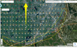
This is Worcester, MA airport (Class D, yellow arrow)
At almost the entirely of the edge around the perimeter of the altitude restricted areas are 0' grids.
There's a very small few that aren't. But makes no sense to go from 100, 200, 300, 400' and then back to 0' furthest away from airport.

Any thoughts on why this is or if indeed a glitch of some sort?


AirMap_Web_App.png
 
I just looked on the ArcGIS website at the UAS Facilities map and it shows the same information. I think this is a screw up in the data when they converted to the quarter sections in a recent update of the Facilities Map. The old sections were halved vertically and horizontally giving 1/4 sections now.
 
Reach out to [email protected] and they can steer you in the right direction. You can also try calling the ATC manager and ask why the entire UASFM is ringed by 0 grids.
 
Reach out to [email protected] and they can steer you in the right direction. You can also try calling the ATC manager and ask why the entire UASFM is ringed by 0 grids.
Thank you for the suggestion @Vic Moss
I emailed my question and had a reply within 15 minutes.

I included the same screenshot that I had inserted here.

This was the question:

1.png

This was the response:


2.png


So I didn't think he understood the question or looked at the attachment I included.

So I emailed him back:

1.png

2.png

AND HIS REPLY:

3.png


So now I am more confused than ever on why that exists like that.
I have no idea how to contact the local and regional airspace manager to ask what is going on.


Attachments

  • 1.png
    1.png
    170.5 KB · Views: 0
  • Wow
Reactions: DoomMeister
Thank you for the suggestion @Vic Moss
I emailed my question and had a reply within 15 minutes.

I included the same screenshot that I had inserted here.

This was the question:

View attachment 139589

This was the response:


View attachment 139590


So I didn't think he understood the question or looked at the attachment I included.

So I emailed him back:

View attachment 139591

View attachment 139593

AND HIS REPLY:

View attachment 139594


So now I am more confused than ever on why that exists like that.
I have no idea how to contact the local and regional airspace manager to ask what is going on.
Those are absurdly poor answers from the help desk, which is rather unusual. It appears he just couldn't be bothered. You could try calling to see if you get a more reasonable answer, or try your local FSDO.
 
Those are absurdly poor answers from the help desk, which is rather unusual. It appears he just couldn't be bothered. You could try calling to see if you get a more reasonable answer, or try your local FSDO.
Please forward that email to me. I'll reach out to my contacts at the UAS office. [email protected]

His answer is obviously incorrect. I've never seen another UASFM ringed with 0 grids. But he may mean that the airport is. It looks like he misunderstood the question.
 
  • Like
Reactions: DoomMeister
Please forward that email to me. I'll reach out to my contacts at the UAS office. [email protected]

His answer is obviously incorrect. I've never seen another UASFM ringed with 0 grids. But he may mean that the airport is. It looks like he misunderstood the question.
It looks like he first misunderstood the question, then got it but couldn't be bothered to investigate what is obviously a mistake.
 
  • Love
Reactions: DoomMeister

DJI Drone Deals

New Threads

Forum statistics

Threads
134,488
Messages
1,595,568
Members
163,014
Latest member
MeDroningOn
Want to Remove this Ad? Simply login or create a free account