DJI Mavic, Air and Mini Drones
Friendly, Helpful & Knowledgeable Community
Join Us Now

400 ft ATO -- But higher AGL?

Status
Not open for further replies.
Absent technology on the drone that very accurately measures height above the ground the only way you can hope to stay compliant is using a significant margin of error when you fly. If you're flying in hilly terrain making judgements about AGL probably become more difficult as distances horizontally increase. Is the technology currently available conducive to putting it on small drones given considerations of cost, size and weight? Are they accurate enough to account for flying over trees, buildings or other object that could interfere with accurate readings of AGL and insure you don't bust the 400' limit?
At this point I know the terrain in my little canyon well enough that I'm comfortable estimating my AGL from the view on the phone. I did a number of tests, going to various locations and then viewing them from 100 ft ATO, 200 ft, etc up to 400 ft.

If you spend enough time doing it, in the same place, you can get good at it.

If I was flying somewhere new, I'd increase my margin of error a bit.

Thx,

TCS
 
Everything in terms of UAS is AGL.... imagine a 400' string hanging from your aircraft... if at any moment it isn't touching the ground you are NOT compliant .

I cringe every time I see you say ATO as it could easily confuse other UAS operators.


AGL AGL AGL AGL AGL

:)
Yes, I for one knew the answer right off the top off my head when I started reading this thread. But, by the time I got halfway through, I began wondering if I was on top of Everest when I lifted off with ATO of 29,032 feet, could I circumvent the globe in the jet stream if my battery lasted? Or, would I finally at that altitude be outside the NAS and therefore beyond FAA jurisdiction so who cares?

1649605457693.png

Members of DJI Nepal Drone Club patiently wait their turn to launch at the top of the world which is now officially recognized as 0 ATO permitting flights in the jet stream.
 
Last edited:
  • Haha
Reactions: BigAl07
Yes, I for one knew the answer right off the top off my head when I started reading this thread. But, by the time I got halfway through, I began wondering if I was on top of Everest when I lifted off with ATO of 29,032 feet, could I circumvent the globe in the jet stream if my battery lasted? Or, would I finally at that altitude be outside the NAS and therefore beyond FAA jurisdiction so who cares?

View attachment 146573

Members of DJI Nepal Drone Club patiently wait their turn to launch at the top of the world which is now officially recognized as 0 ATO permitting flights in the jet stream.
The FAA has jurisdiction for all US airspace above 18,000 ft.

Hard to maintain VLOS with the flight plan that you suggest...

;-)

TCS
 
  • Like
Reactions: Chip
Is the technology currently available conducive to putting it on small drones given considerations of cost, size and weight?
In a word, no.

For a typical entry-level radar altimeter used in small planes, consider the Bendix/King KRA-10. The radio portion (leaving out the dial indicator on the dashboard) is 3.1" x 3.5" x 8.0", or 7.9 x 8.9 x 30.3cm. Weight is 2.01 lbs. The required antenna add 0.9 lbs. Power consumption is 5.5W. Price around $5000.

Much of the price surely has to do with liability insurance and certification requirements, which would be relaxed somewhat for uncrewed VFR flight, compared with human flight in IFR conditions. Another point is that the KRA-10 works up to 2,500 ft. Reducing the range to something like 500 ft would significantly reduce power consumption and probably size/weight. But still, I'm not expecting to see one on something the size/cost of a Mavic Mini any time soon.
I wouldn't use that architecture at all to get AGL altitude.

I'd integrate the existing GPS position data that the drone already has, with a terrain data base that has the MSL elevations for the GPS locations in the region in question.

Then it's just math.

Take the MSL altitude of the take-off point, add the ATO altitude that the drone displays already, subtract the database-known MSL altitude of the current GPS location directly under the drone, and Presto!

AGL altitude.

As precise as radar? No.

Good enough? Absolutely!

There would be zero or virtually zero new hardware involved. Maybe a memory/processor chip.

I expect the biggest per unit cost would be the licensing fee for the terrain database.

Conceptually, it's not hard. I don't even think the coding would be that hard. I think providing this would seriously improve compliance with the 400 ft AGL rule. If Ms Fly yelled at you when you got to 400 ft AGL, rather than 400 ft ATO as she does now, it would matter more to people. Even an actual flight control hold at that point, which should be dismissible, shouldn't be that hard.

Of course, if you're a flatland flier, none of this matters...

:)

TCS
 
  • Like
Reactions: Rich QR
At this point I know the terrain in my little canyon well enough that I'm comfortable estimating my AGL from the view on the phone. I did a number of tests, going to various locations and then viewing them from 100 ft ATO, 200 ft, etc up to 400 ft.

If you spend enough time doing it, in the same place, you can get good at it.

If I was flying somewhere new, I'd increase my margin of error a bit.

Thx,

TCS
I think that is one of the issues for new fliers, they haven't yet had a chance to put enough time into doing it to accurate judge height above the ground where terrain elevation changes significantly in a particular location. It's a reason to use the altitude geofensing and be conservative when setting a limit. Even with that it can be challenging.
 
If you launch a drone from the edge of a cliff, under the Rec rules, and you stay under 400 ft ATO, are you legal if you fly out to a point where you're 1000 ft AGL?

Assume hard VLOS is maintained.

Legal?

Thx,

MM
This has been covered so many times. The simple answer to (your) question, is no.
 
If you are flying over trees, you can be 400’ above those and still be in compliance. If you are inspecting a cell tower, you can be 400’ above that even if it is a 1000’ foot tower! So agl is relative to what’s below you.

Negative!! That's NOT accurate. Trees are not Structures. . .

As a Recreational Flyer you must remain 400' AGL with no exceptions.

As Part 107 you must remain 400' AGL unless you're within 400. of a STRUCTURE (not not in Controlled Airspace) but trees are NOT structures and do not get factored into Altitude for either type of flying.
 
I wouldn't use that architecture at all to get AGL altitude.

I'd integrate the existing GPS position data that the drone already has, with a terrain data base that has the MSL elevations for the GPS locations in the region in question.

Then it's just math.

Take the MSL altitude of the take-off point, add the ATO altitude that the drone displays already, subtract the database-known MSL altitude of the current GPS location directly under the drone, and Presto!

AGL altitude.

As precise as radar? No.

Good enough? Absolutely!

There would be zero or virtually zero new hardware involved. Maybe a memory/processor chip.

I expect the biggest per unit cost would be the licensing fee for the terrain database.

Conceptually, it's not hard. I don't even think the coding would be that hard. I think providing this would seriously improve compliance with the 400 ft AGL rule. If Ms Fly yelled at you when you got to 400 ft AGL, rather than 400 ft ATO as she does now, it would matter more to people. Even an actual flight control hold at that point, which should be dismissible, shouldn't be that hard.

Of course, if you're a flatland flier, none of this matters...

:)

TCS
I believe you are incorrect. The gps systems on drones do very well locating positions. They are not so good at elevations. I believe that is why you won't find drones providing the information you are wanting. Comparing gps elevations to topographical charts is no simple trick either. I believe the hardware required is more significant than you are suggesting.

You stated that the information provided would be good enough. What is good enough for you. Within 20 ft? 100 ft? I suggest that if you are aware of your surroundings, and stay within the rules, good enough is achievable without the electronics you are wanting.
 
  • Like
Reactions: maggior
I'd integrate the existing GPS position data that the drone already has, with a terrain data base that has the MSL elevations for the GPS locations in the region in question.
Then it's just math.

Such systems do exist, sort of, but it all has to be pre-calculated. Current drones do not have the memory capacity to store the entire Google Earth elevation database.

For example, MapsMadeEasy and Map Pilot Pro use exactly this sort of system for enabling "terrain awareness" in their mapping apps.

You mark the grid that you want to map, and configure the app to hold a specific constant height above ground for the duration of the flight. The app generates the required grid points for each photo, and compares those grid locations to the relative sea level elevations recorded in a database like Google Earth. The app does the math to compare those elevations relative to the drone's takeoff height, The app then uploads all the waypoints, including height required, to the drone allowing it to fly the mission autonomously at a consistent terrain following height above ground.

The app does all the math beforehand. The drone itself is still only ever "aware" of its height measured barometrically relative to its takeoff location. The waypoints uploaded to the drone tell it to climb or descend as required to reach each pre-plotted waypoint while maintaining a constant height above ground, automatically rising and descending as though it's "aware" of the terrain.

 
Extremely simple. Recreational SUAS operators are limited to no more than 400 feet AGL.
Part 107 pilots may go 400' above structures if they remain within 400' horizontally from the structure.
It would only be extremely simple if the rules treated every hazardous obstacle the same way. But it doesn't.

Recreational pilots cannot fly over trees that are taller than 400'. Neither can Part 107 pilots! They're only allowed to fly higher over tall "structures", and as BigAl07 points out, trees are not structures.

Everyone is allowed to fly 400' higher than any terrain "ground" feature composed of natural earth and rocks, since you're always allowed to fly up to 400' above "ground". So why is ground treated differently than structures? And why aren't trees considered as "ground"? Why do you first need to figure out whether a particular obstacle of earth/rocks is a natural terrain "ground" feature versus a man-made "structure" of earth/rocks? They're each equally obstacles in the way of aviation.

I posted several images a couple of days ago illustrating these questions over in another thread:
mavicpilots.com/threads/why-1400-ft-max-altitude.124266/page-4#post-1408241

Trees are not Structures. . .
As a Recreational Flyer you must remain 400' AGL with no exceptions.

I can think of one exception.

What exactly is the "ground" when one refers to AGL? Structures are not ground, and trees are not structures, and trees are also not ground. So trees just don't exist at all, even though they're an obvious hazard to aviation.

So when is "ground" not actually a natural terrain feature composed of earth or rocks (not trees), and definitely never to be confused with un-natural rock/earth man-made "structure"?

The exception is that 400' AGL is not always measured from solid ground. It's also frequently measured from the top surface of any body of water, rather than from the solid ground at the lake's bottom. Trees are not structures and not ground. Water is not a structure, but it is ground. Okay.

Here's another example where the 400' AGL, with no exceptions, for Recreational Pilots is neither extremely simple nor obvious.

Lets pick an obvious "obstacle" like the Hoover Dam. NOTE: You're not actually allowed to fly over the Hoover Dam. It's a strict NFZ. Flying a Chinese drone to take surveillance images over such a vulnerable "structure" is a threat to Homeland Security. Of course any tourists, even Chinese tourists, are instead welcome to drive their car along the top of the dam, and stop at the visitor centre to take a tour of the power plant and snap as many photos as they like. You just can't do it using a drone, because... Well, um, just because.

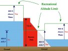
Solely for the purpose of this example, assume that Recreational Pilots are allowed to fly over the Hoover Dam. Below is a cross sectional diagram. How high would you be allowed to fly here?

The dam itself is 726' high, presumably measured from the "ground" up. So, if you're never allowed to fly higher than 400' above "ground", you'd never be allowed to fly over this dam.

But you're in luck, because apparently one can measure AGL relative to the top of the water's surface, not actually from the "ground". Don't ignore the fact that the water level in this reservoir can fluctuate quite dramatically. But assume that, arriving from upstream at a height not exceeding 400' AGL, you can clear the top of the dam.

Bit wait! You still cannot cross over the top of the dam! Remember that dam is a "structure", not "ground". That 726' tall stucture is taller than 400' AGL, therefor Recreational Pilots CANNOT fly over it, (even if it wasn't a NFZ).

What about if you approach the dam from downstream? You can only fly as high as 400' above the water's surface, nowhere near high enough to clear the dam.

And, it gets worse. Right at the point where the water's surface touches the dam's face, you'd must descend. You're only allowed to fly 400' above "ground" (or water), but only Part 107 pilots are allowed to fly an additional 400' above a "structure". The moment you cross leave the surface of the water and are now over the surface of the "structure" of the dam, Recreational pilots are required to descend to a point no higher than 400" above "ground" (not above structure). And good luck figuring out how far that actual unseen "ground" is buried beneath all that concrete "structure".

It's all "extremely simple". Ya right.

Why do we need to distinguish between "ground (including water)" versus "structures", with different rules depending on which is which. Why not have one consistent rule for 400' over any hazardous obstacle?

HooverDam.jpg
 
At this point I know the terrain in my little canyon well enough that I'm comfortable estimating my AGL from the view on the phone. I did a number of tests, going to various locations and then viewing them from 100 ft ATO, 200 ft, etc up to 400 ft.

If you spend enough time doing it, in the same place, you can get good at it.

If I was flying somewhere new, I'd increase my margin of error a bit.

Thx,

TCS
Like many things it's hard until it becomes simple. It's been said landing an aircraft is the hardest part of learning to fly. Why? Because it takes a certain amount of practice to learn how to accurate judge when it's the right time to flare. Then it becomes easy.
 
I think that is one of the issues for new fliers, they haven't yet had a chance to put enough time into doing it to accurate judge height above the ground where terrain elevation changes significantly in a particular location. It's a reason to use the altitude geofensing and be conservative when setting a limit. Even with that it can be challenging.
The best cure for ignorance about flying issues, is to fly a lot!

:)

TCS
 
I believe you are incorrect. The gps systems on drones do very well locating positions. They are not so good at elevations. I believe that is why you won't find drones providing the information you are wanting. Comparing gps elevations to topographical charts is no simple trick either. I believe the hardware required is more significant than you are suggesting.

You stated that the information provided would be good enough. What is good enough for you. Within 20 ft? 100 ft? I suggest that if you are aware of your surroundings, and stay within the rules, good enough is achievable without the electronics you are wanting.
+/- 20 ft would certainly be fine. More important than the size of the error margin, is knowing what it is!

What you would you need new hardware for? I mean, to perform what specific function? I suppose if you want to count some small chip set as "hardware", then perhaps, but you wouldn't need new sensors or a bigger power supply of anything like that.

What function do you have in mind for this additional HW?

Thx,

MM
 
Such systems do exist, sort of, but it all has to be pre-calculated. Current drones do not have the memory capacity to store the entire Google Earth elevation database.

For example, MapsMadeEasy and Map Pilot Pro use exactly this sort of system for enabling "terrain awareness" in their mapping apps.

You mark the grid that you want to map, and configure the app to hold a specific constant height above ground for the duration of the flight. The app generates the required grid points for each photo, and compares those grid locations to the relative sea level elevations recorded in a database like Google Earth. The app does the math to compare those elevations relative to the drone's takeoff height, The app then uploads all the waypoints, including height required, to the drone allowing it to fly the mission autonomously at a consistent terrain following height above ground.

The app does all the math beforehand. The drone itself is still only ever "aware" of its height measured barometrically relative to its takeoff location. The waypoints uploaded to the drone tell it to climb or descend as required to reach each pre-plotted waypoint while maintaining a constant height above ground, automatically rising and descending as though it's "aware" of the terrain.

Great info, thanks! This is entirely consistent with the kind of thing I had in mind.

How expensive are these mapping systems? Will they run on a Mini-2?

:)

MM
 
It would only be extremely simple if the rules treated every hazardous obstacle the same way. But it doesn't.

Recreational pilots cannot fly over trees that are taller than 400'. Neither can Part 107 pilots! They're only allowed to fly higher over tall "structures", and as BigAl07 points out, trees are not structures.

Everyone is allowed to fly 400' higher than any terrain "ground" feature composed of natural earth and rocks, since you're always allowed to fly up to 400' above "ground". So why is ground treated differently than structures? And why aren't trees considered as "ground"? Why do you first need to figure out whether a particular obstacle of earth/rocks is a natural terrain "ground" feature versus a man-made "structure" of earth/rocks? They're each equally obstacles in the way of aviation.

I posted several images a couple of days ago illustrating these questions over in another thread:
mavicpilots.com/threads/why-1400-ft-max-altitude.124266/page-4#post-1408241


I can think of one exception.

What exactly is the "ground" when one refers to AGL? Structures are not ground, and trees are not structures, and trees are also not ground. So trees just don't exist at all, even though they're an obvious hazard to aviation.

So when is "ground" not actually a natural terrain feature composed of earth or rocks (not trees), and definitely never to be confused with un-natural rock/earth man-made "structure"?

The exception is that 400' AGL is not always measured from solid ground. It's also frequently measured from the top surface of any body of water, rather than from the solid ground at the lake's bottom. Trees are not structures and not ground. Water is not a structure, but it is ground. Okay.

Here's another example where the 400' AGL, with no exceptions, for Recreational Pilots is neither extremely simple nor obvious.

Lets pick an obvious "obstacle" like the Hoover Dam. NOTE: You're not actually allowed to fly over the Hoover Dam. It's a strict NFZ. Flying a Chinese drone to take surveillance images over such a vulnerable "structure" is a threat to Homeland Security. Of course any tourists, even Chinese tourists, are instead welcome to drive their car along the top of the dam, and stop at the visitor centre to take a tour of the power plant and snap as many photos as they like. You just can't do it using a drone, because... Well, um, just because.

Solely for the purpose of this example, assume that Recreational Pilots are allowed to fly over the Hoover Dam. Below is a cross sectional diagram. How high would you be allowed to fly here?

The dam itself is 726' high, presumably measured from the "ground" up. So, if you're never allowed to fly higher than 400' above "ground", you'd never be allowed to fly over this dam.

But you're in luck, because apparently one can measure AGL relative to the top of the water's surface, not actually from the "ground". Don't ignore the fact that the water level in this reservoir can fluctuate quite dramatically. But assume that, arriving from upstream at a height not exceeding 400' AGL, you can clear the top of the dam.

Bit wait! You still cannot cross over the top of the dam! Remember that dam is a "structure", not "ground". That 726' tall stucture is taller than 400' AGL, therefor Recreational Pilots CANNOT fly over it, (even if it wasn't a NFZ).

What about if you approach the dam from downstream? You can only fly as high as 400' above the water's surface, nowhere near high enough to clear the dam.

And, it gets worse. Right at the point where the water's surface touches the dam's face, you'd must descend. You're only allowed to fly 400' above "ground" (or water), but only Part 107 pilots are allowed to fly an additional 400' above a "structure". The moment you cross leave the surface of the water and are now over the surface of the "structure" of the dam, Recreational pilots are required to descend to a point no higher than 400" above "ground" (not above structure). And good luck figuring out how far that actual unseen "ground" is buried beneath all that concrete "structure".

It's all "extremely simple". Ya right.

Why do we need to distinguish between "ground (including water)" versus "structures", with different rules depending on which is which. Why not have one consistent rule for 400' over any hazardous obstacle?

View attachment 146590
Great analysis, thanks!

As a matter of effective law, I seriously doubt that anyone is ever going to get dinged for flying 400 ft above the treetops, unless it's incidental to some other more serious violation.

But it's sometimes useful to point out some of the silly edges of the text of the law as well.

:)

MM
 
Like many things it's hard until it becomes simple. It's been said landing an aircraft is the hardest part of learning to fly. Why? Because it takes a certain amount of practice to learn how to accurate judge when it's the right time to flare. Then it becomes easy.
Exactly!

:)

TCS
 
Great info, thanks! This is entirely consistent with the kind of thing I had in mind.
How expensive are these mapping systems? Will they run on a Mini-2?
I explained how you can do mapping entirely for free in this post:
mavicpilots.com/threads/drone-mapping.124355/#post-1407306

There are limitations though when using something like a Mini versus more capable drones.

Many people use and recommend DroneDeploy, but according to their website they don't support my Mini or my Phantom 3 Pro.
 
Status
Not open for further replies.
Lycus Tech Mavic Air 3 Case

DJI Drone Deals

New Threads

Forum statistics

Threads
131,240
Messages
1,561,187
Members
160,192
Latest member
Britt