DJI Mavic, Air and Mini Drones
Friendly, Helpful & Knowledgeable Community
Join Us Now

AGL

According to CASA (Australia) regulation, when you're planning your flight operation and if you need to take into account the height limit in a restricted airspace.
You have to set up the drone height limit = (AMSL - AGL) all over the area of you operation.
The max allowed in Australia is 400 ft AMSL.
Which means if you're planning to fly in a restricted airspace from the top of a hill 400ft AMSL you'll not get authorised by CASA for flight mission.
That's as far as I understand the rules.
You can certainly get authorisations to fly higher, as long as you are correctly certified and submit correct documentation before flight. (And of course, ensure the authorisation has been approved)
 
In the U.S. the legal limit is 400' AGL unless you're within 400' diameter of a tower or structure (or cliff), in which case you can fly next to and up to 400' above that object. Find a 1000' tower and, assuming there are no other airspace restrictions, you can fly up to 1400' AGL as long as you stay with 400' of it.
Unless the rules for hobby pilots have changed then I think you are mistaken. I believe the rule is strictly AGL for hobby pilots.
That I remember reading, there is, for part 107 pilots, a "within 'x'ft of a structure" allowance that allows them to fly up the side of a structure to more than 400ft AGL providing they do not go more than 400ft above the structure and are within the "'x'ft of " column but I recollect it applies to man made structures only, NOT terrain.

Perhaps @BigAl07 etc. can chime in here, I welcome correction if I am wrong.
 
Last edited:
Unless the rules for hobby pilots have changed then I think you are mistaken. I believe the rule is strictly AGL.
That I remember reading, there is, for part 107 pilots, a "within 'x'ft of a structure" allowance that allows them to fly up the side of a structure to more than 400ft AGL providing them do not go more than 400ft above the structure and are within the "'x'ft of " column but I recollect it applies to man made structures only, NOT terrain.

Perhaps @BigAl07 etc. can chime in here, I welcome correction if I am wrong.
You are correct. A 107 can fly 400' above a structure while within 400' horizontal. Recreational can not.
 
I cant find videos or info in the DJI manual that answers this question........... If i am on a montain and set the drone to 100 feet AG in intelligent flight will it maintain the level of where it started or drop down in to the valley until it reaches 100 feet AGL in that new area? DJI Mini 3 Pro
Just to add this to the discussion.

I am Part 107 Licensed and I recently received an Authorization from the FAA through the FAADroneZone to fly for a 3-month period in a Zero (0)-Foot Maximum UAS Facility Map Altitude Grid wholly within the Controlled Class D Airspace of Langley AFB, VA.

The purpose of this Authorization was to perform Roof and Gutter Inspections on every home on a two-block length of a local street. Since the neighborhood is entirely within a "Drone Taxi Zone" (cannot fly at all in this area…) and the Neighborhood is filled with old growth, mature trees that average just over 100-feet, I restricted my request to a maximum altitude of 75-feet.

This is the way the FAA restricted me to this operation… and it's all AGL…

auth.png

I guess they wanted to avoid a repeat of last month's shoot down of the "Chinese Party Balloon" (LoL)…

Believe it or not.png
 
In the U.S. the legal limit is 400' AGL unless you're within 400' diameter of a tower or structure (or cliff), in which case you can fly next to and up to 400' above that object. Find a 1000' tower and, assuming there are no other airspace restrictions, you can fly up to 1400' AGL as long as you stay with 400' of it.

I figured you knew about national parks, but I had to throw that in since the 400' question is the least of the worries.


Partially WRONG!! Let's break this down:

In the US, if the pilot is Part 107, and there are no other restrictions at play (airspace etc), they can operate 400' over a STRUCTURE if within 400' of the SRUCTURE.

  • This rule is for Part 107 and ONLY Part 107.
  • This rule is about STRUCTURES and have nothing to do with cliffs, banks, trees, etc etc. Think TOWER, Building, Bridge... structures are Man Made CONSTRUCTION and not earth etc.
Hobby operators are restricted to 400'AGL (measured directly under the aircraft) and currently there are no lateral "easements" etc for exceeding 400' AGL.

Lastly, any Airspace Authorizations are HARD limits. If you have an authorization saying, "Flight up to 120' AGL" you can't add that 120' to a structure. It's 120' AGL and ONLY 120' AGL.
 
No. You cant fly in an active PRD zone without clearance. But it should be pointed out that not all PRD areas are active from SFC. If a PRD is 1000-7500, then you could certainly fly under this area to 400ft
Dji drones allow you to set the height you want to limit, but this in relation to height above takeoff point and nothing to do with rules/laws. It gets its height information from a barometer reading in relation to pressure reading at take off. It has no idea of AMSL or elevation at take off point. Just comparing two pressure readings of take off point and its current location.
Dont assume that because the dji drone is letting you fly somewhere, that it is a legal flight.
Where are you sourcing your information?
Im wondering if you have just misinterpreted something, or has someone taught you that?
Sort of a miscommunication.
I was speculating about technical ability to fly above 400ft in Australia in a non-PRD zone.
I found out that there is an engineering limit 500m (1,640ft) in my model of the DJI Mavic 2 Pro RPA.
 
  • Wow
Reactions: LoudThunder
Just to add this to the discussion.

I am Part 107 Licensed and I recently received an Authorization from the FAA through the FAADroneZone to fly for a 3-month period in a Zero (0)-Foot Maximum UAS Facility Map Altitude Grid wholly within the Controlled Class D Airspace of Langley AFB, VA.

The purpose of this Authorization was to perform Roof and Gutter Inspections on every home on a two-block length of a local street. Since the neighborhood is entirely within a "Drone Taxi Zone" (cannot fly at all in this area…) and the Neighborhood is filled with old growth, mature trees that average just over 100-feet, I restricted my request to a maximum altitude of 75-feet.

This is the way the FAA restricted me to this operation… and it's all AGL…

View attachment 161241

I guess they wanted to avoid a repeat of last month's shoot down of the "Chinese Party Balloon" (LoL)…

View attachment 161242
I wonder, how are you planning to fly over the roof on the other side and the RC signal lost?
 
  • Wow
Reactions: LoudThunder
I think that you will find that sea level, AMSL, is irrelevant to the legal height limit of a drone, unless the drone happens to be over the sea.
All height limits tend to be relative to the ground directly beneath the drone e.g. a weighted string, 400ft long, tied to the bottom of the drone, should be able to touch the ground directly beneath the drone. If you are over water then the water's surface counts as the ground's surface.
 
Last edited:
  • Wow
Reactions: LoudThunder
You don't know what AMSL means, do you?
According to CASA CAR 157 the lowest level for an aircraft to fly in a non-populated area is 500 ft AMSL as far as I remember.
Which gives a 100ft gap between the drone and the plane to avoid collision.
Am I missing some latest changes in CASA regulations?

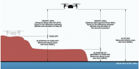
I think the following drawing can be a good base reference point to the discussion.
1677840323875.png
 
  • Wow
Reactions: LoudThunder
No dude you are completely wrong. You cannot fly lower than 500ft above ground level or structure. You are really confusing your rules or I’m guessing you have been taught wrong. Who did you do your training through?
 
  • Wow
Reactions: LoudThunder
CAR 157 states
Low flying
An aircraft must not fly over:
(a) any city, town or populous area at a height lower than 1,000 feet; or
(b) any other area at a height lower than 500 feet.


What is height and altitude in aviation?


Height: Vertical distance from the point of observation on the Earth's surface to the point being measured. Altitude: Vertical distance from mean sea level to the point being measured.

It is a pilot’s responsibility to know his height through the use of charts and accurate navigation
 
Last edited:
  • Wow
Reactions: LoudThunder
@Azarov , do you hold a RePL. You have mentioned elsewhere that you hold an AROC so I am assuming you do. You have also discussed documentation that you prepare for flights and this is consistent with a commercial operator. But, your lack of knowledge around this important information does concern me and I am concerned you have been taught wrong. There are still a handful of rogue trainers here in Australia and we are always working to eliminate poor training providers.
Would you be willing to PM me with more information about your training?
 
  • Wow
Reactions: LoudThunder
No dude you are completely wrong. You cannot fly lower than 500ft above ground level or structure. You are really confusing your rules or I’m guessing you have been taught wrong. Who did you do your training through?
Interesting. You're saying that I can legally fly my drone 400ft AGL in R405B restricted airspace at Macquarie lighthouse which is at elevation of 80m AMSL?
 
  • Wow
Reactions: LoudThunder
According to CASA CAR 157 the lowest level for an aircraft to fly in a non-populated area is 500 ft AMSL as far as I remember.
Which gives a 100ft gap between the drone and the plane to avoid collision.
Am I missing some latest changes in CASA regulations?
I was much too subtle for you.
FYI .. AMSL = above mean sea level.
If your interpretation was true ... no-one could fly a drone in Australia unless they were close to the coast.

Think about it ... how could you fly at Bathurst elevation = 650 metres AMSL
Or Toowoomba elevation = 690 metres AMSL
Or Ballarat elevation = 460 metres AMSL
 
  • Wow
Reactions: LoudThunder
Ok guys, I think you're right, 400ft AGL.

I was pressed by Sydney Harbour Trust not to fly above 110ft at Macquarie lighthouse, see their diagram below.
I was trying to argue but decided to take a mission rather then missing this unique chance continue arguing.

1677844289716.jpeg
 
  • Wow
Reactions: LoudThunder
I wonder, how are you planning to fly over the roof on the other side and the RC signal lost?
I am not quite sure what you are asking, perhaps you are even asking about the "Joke Photo of my Mini 2 at 15,000' , flying at almost 500 MPH…"

Also, I am in the USA that posting was from the FAA's Authorization to fly in Virginia, USA.

But if not, this authorization allows me to fly my drone everywhere within the 1/10 NM circle of the center of the homes as long as I do not exceed 75' AGL… This area is technically a no fly zone because of its proximity to an active Air Force Base, with I have this authorization and as long as I follow the rules as set forth by the FAA (check NOTAMS, call the ATC, etc…) I can fly all day long.

As for loss of signal??? I have sat on the front step of the local three story, brick high school and flown my drone all the way around the school (and it's a huge school…), using just the video feed to guide it (FPV) and I had no loss of signal. (Yeah, I know that once the drone went around the corner of the school and I could no longer see it, I was in the wrong; but it was the weekend, early n the morning and no one else was around…). So, with even this humongous brick structure between me and my drone, I always had Green signal strength and it never went Yellow…

Now, I have flown the drone in the woods and sometimes, the signal strength gets Yellow, when I get too many trees in the way…

I hope this answers your question.

LT Signing Off…
 
Interesting. You're saying that I can legally fly my drone 400ft AGL in R405B restricted airspace at Macquarie lighthouse which is at elevation of 80m AMSL?
R405B is surface to 1000 so without authorisation you can’t fly there at all

I don’t understand your hand drawn diagram. is this what you were getting approved?
 
Last edited:
  • Wow
Reactions: LoudThunder
In the U.S. the legal limit is 400' AGL unless you're within 400' diameter of a tower or structure (or cliff), in which case you can fly next to and up to 400' above that object. Find a 1000' tower and, assuming there are no other airspace restrictions, you can fly up to 1400' AGL as long as you stay with 400' of it.

I figured you knew about national parks, but I had to throw that in since the 400' question is the least of the worries.

The 400' above structures rule is for Part 107 rated pilots only. And it doesn't apply to terrain features.
 
  • Like
Reactions: LoudThunder

DJI Drone Deals

New Threads

Forum statistics

Threads
134,560
Messages
1,596,272
Members
163,062
Latest member
rstegner
Want to Remove this Ad? Simply login or create a free account