

I am using Airmap to tell me what the restrictions are around places I intend to fly.
However I still have a few question on the use of this app.
I am going to throw out a few understandings .. if any of it is wrong, someone please correct me.
First.. I fly for fun. Not a commercial flyer.
So if my circle is not green.. ie there are some advisories I assume that means I am not within 5 miles of an airport or heliport...Then there is nothing I need to do.
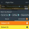
Most of the time my area has orange or yellow.. which implies I have heliports and schools in the circle.
These heliports have phone numbers listed and there are usually more than one heliports. .
1) Do I need to call all these heliports to notify them ?
2) Does the app electronically send notifications to them when you create your flight and submit ?
3) If this is not a restricted airspace requiring AUTHORIZATION.. once you submit your flight on the app, what happen ? Does the flight plan get sent off to the heliport for notification ? Do I need to wait for any kind of text to confirm that everything is cool ?
4) If there are restricted airspace requiring authorization.. I have seen youtube video of a guy submitting his flight via the app to get authorization and he got a text to confirm this..
But if this wasn't a situation where authorization is needed .. only notification.. Will there be any kind of textual confirmation coming ? Or can I just start flying ?
Again.. I am only interested in casually flying my mavic less than 150 feet most time ...
It seems like a lot of work if every time I get orange circles that I have to make phone calls to all these heliports.
And as far as schools are concerned.. I understand you are not supposed to fly OVER them... That's all.
Airmap just only inform you that they are in the area. Correct me if I am wrong on any of these points.
If someone who regularly uses Airmap can answer these, I'd appreciate your inputs.
Rather than quoting the FAA regulations.. I'd prefer to hear what people do when they actually take their drones out to their local park to fly for fun less than 200 ft AGL, do you yourselves call it in, every time ?
Seems like most youtube videos out there that talks about regulations.. never really address it from the view point of a recreational flyer.. more from commercial.
However I still have a few question on the use of this app.
I am going to throw out a few understandings .. if any of it is wrong, someone please correct me.
First.. I fly for fun. Not a commercial flyer.
So if my circle is not green.. ie there are some advisories I assume that means I am not within 5 miles of an airport or heliport...Then there is nothing I need to do.
Most of the time my area has orange or yellow.. which implies I have heliports and schools in the circle.
These heliports have phone numbers listed and there are usually more than one heliports. .
1) Do I need to call all these heliports to notify them ?
2) Does the app electronically send notifications to them when you create your flight and submit ?
3) If this is not a restricted airspace requiring AUTHORIZATION.. once you submit your flight on the app, what happen ? Does the flight plan get sent off to the heliport for notification ? Do I need to wait for any kind of text to confirm that everything is cool ?
4) If there are restricted airspace requiring authorization.. I have seen youtube video of a guy submitting his flight via the app to get authorization and he got a text to confirm this..
But if this wasn't a situation where authorization is needed .. only notification.. Will there be any kind of textual confirmation coming ? Or can I just start flying ?
Again.. I am only interested in casually flying my mavic less than 150 feet most time ...
It seems like a lot of work if every time I get orange circles that I have to make phone calls to all these heliports.
And as far as schools are concerned.. I understand you are not supposed to fly OVER them... That's all.
Airmap just only inform you that they are in the area. Correct me if I am wrong on any of these points.
If someone who regularly uses Airmap can answer these, I'd appreciate your inputs.
Rather than quoting the FAA regulations.. I'd prefer to hear what people do when they actually take their drones out to their local park to fly for fun less than 200 ft AGL, do you yourselves call it in, every time ?
Seems like most youtube videos out there that talks about regulations.. never really address it from the view point of a recreational flyer.. more from commercial.
Attachments
Last edited:


