DJI Mavic, Air and Mini Drones
Friendly, Helpful & Knowledgeable Community
Join Us Now

Allowable Height

photoshop67

Active Member
Joined
Feb 14, 2017
Messages
30
Reactions
8
Age
74
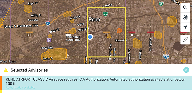
We are just 1500 feet outside of an Authorization Zone for a local airport. I have two questions.

Where do I look to find out:

1. How high am I allowed to fly in this area.

2. How low are airplanes allowed to fly in this area.
 
If you are in the US, you should be able to get all the flight information you need about how high you are allowed to fly your drone above the ground from a suitable app such as AirControl especially when you seek to obtain LAANC authorization using the app while in controlled airspace such as near an airport. In the event you are in uncontrolled airspace, you are allowed to fly no higher than 400 feet above the ground.

Please complete the TRUST test for further details and you should also know there is no official floor for how low aircraft can fly anywhere meaning it is possible you can always encounter manned aircraft in the same space with your drone so please give way and stay safe.
 
Last edited:
I think I found my allowable height on this site, but not 100% sure that it represents my limit, and I do not see a reference to how low an aircraft can fly.

FAA UAS Facility Map: Dupage
 
I think I found my allowable height on this site, but not 100% sure that it represents my limit, and I do not see a reference to how low an aircraft can fly.

FAA UAS Facility Map: Dupage
The controlled airspace for the Dupage Airport west of Chicago is shown here. EDIT: Unfortunately, the link doesn't maintain the specific location.


The altitudes shown within controlled airspace in that map are maximum values you may fly with LAANC authorization. Without LAANC authorization, you are not allowed to fly at all in that controlled airspace. Outside controlled airspace, flight up to 400' AGL is permitted.

There are cellphone apps that will allow you to check flight limitations at any location.

There are minimum altitudes for manned aircraft in some situations, but drone pilots should never count on manned aircraft being above a certain altitude. In all cases, drones are always required to give way to manned aircraft.
 
Last edited:
The controlled airspace for the Dupage Airport west of Chicago is shown here. EDIT: Unfortunately, the link doesn't maintain the specific location.


The altitudes shown within controlled airspace in that map are maximum values you may fly with LAANC authorization. Without LAANC authorization, you are not allowed to fly at all in that controlled airspace. Outside controlled airspace, flight up to 400' AGL is permitted.

There are cellphone apps that will allow you to check flight limitations at any location.

There are minimum altitudes for manned aircraft in some situations, but drone pilots should never count on manned aircraft being above a certain altitude. In all cases, drones are always required to give way to manned aircraft.
I thought that being registered with DJI, and using their products would be sufficient for recreational flying.

I do go to DJI Authorization Request site when flying in an Authorization Zone and then import that permission into my craft.
 
I thought that being registered with DJI, and using their products would be sufficient for recreational flying.

I do go to DJI Authorization Request site when flying in an Authorization Zone and then import that permission into my craft.

DJI's Geo Zone system is their own separate effort at improving safety. You have to comply with it to operated in certain areas, typically around airports. It doesn't replace or supplant a country's civil aviation authority regulations.

If you want to fly in controlled airspace in the U.S., as shown in the UAS Facility Maps, FAA regulations require you to get LAANC (Low Altitude Authorization and Notification Capability) authorization from the FAA. In controlled airspace. DJI requires you to submit your LAANC authorization number to unlock their GEO Zone system.

This page provides some background on LAANC.

 
I thought that being registered with DJI, and using their products would be sufficient for recreational flying.

I do go to DJI Authorization Request site when flying in an Authorization Zone and then import that permission into my craft.
The best way to get in trouble by flying where you're not supposed to is to follow what the DJI GEO Map tells you.

Please take your TRUST (FAA TRUST Online Portal for Recreational Drone Operators - Pilot Institute) and you'll learn more. For LAANC approval use AirControl. You can find that app in the Apple Story or Google Play.
 
  • Like
Reactions: mavic3usa and lmh
According to FAA Part 91 (which governs the operation of aircraft): "An altitude of 500 feet above the surface, except over open water or sparsely populated areas. In those cases, the aircraft may not be operated closer than 500 feet to any person, vessel, vehicle, or structure."
and:
"Over any congested area of a city, town, or settlement, or over any open air assembly of persons, an altitude of 1,000 feet above the highest obstacle within a horizontal radius of 2,000 feet of the aircraft.."
Except for the purposes of takeoff or landing.
The 500' minimum altitude in the first paragraph gave rise to the 400' maximum drone altitude as that provides a nominal 100' separation between manned aircraft and drones.
 
Don't forget though, the last part of that 91.119 says;
(d) Helicopters, powered parachutes, and weight-shift-control aircraft. If the operation is conducted without hazard to persons or property on the surface—
(1) A helicopter may be operated at less than the minimums prescribed in paragraph (b) or (c) of this section, provided each person operating the helicopter complies with any routes or altitudes specifically prescribed for helicopters by the FAA; and...

So, you need to be aware that aircraft could be below 500 feet and you must give way to them. Also, is the questioner is near an airport and unaware of traffic patterns, etc, they could also be below 500 and the drone could be a hazard.
 
  • Like
Reactions: Vic Moss
According to FAA Part 91 (which governs the operation of aircraft): "An altitude of 500 feet above the surface, except over open water or sparsely populated areas. In those cases, the aircraft may not be operated closer than 500 feet to any person, vessel, vehicle, or structure."
and:
"Over any congested area of a city, town, or settlement, or over any open air assembly of persons, an altitude of 1,000 feet above the highest obstacle within a horizontal radius of 2,000 feet of the aircraft.."
Except for the purposes of takeoff or landing.
The 500' minimum altitude in the first paragraph gave rise to the 400' maximum drone altitude as that provides a nominal 100' separation between manned aircraft and drones.
This is what I understood from reading about this a year ago. The 400 limit NOT being acceptable it seems around airports since the max height for drones is apparently that shown in the FAA UAS Facility Map. Since I typically fly near an airport, but outside of the Authorization zone by just a little but, my max height according to the FAA UAS Facility Map looks to be 300 feet. Interesting that the Fly app does not seem concerned with flight heights outside of the Authorization zone, but within the area marked out by the FAA UAS Map.
 
If you are in the US, you should be able to get all the flight information you need about how high you are allowed to fly your drone above the ground from a suitable app such as AirControl especially when you seek to obtain LAANC authorization using the app while in controlled airspace such as near an airport. In the event you are in uncontrolled airspace, you are allowed to fly no higher than 400 feet above the ground.

Please complete the TRUST test for further details and you should also know there is no official floor for how low aircraft can fly anywhere meaning it is possible you can always encounter manned aircraft in the same space with your drone so please give way and stay safe.
I have the Trust certificate.
 
  • Like
Reactions: mavic3usa
This is what I understood from reading about this a year ago. The 400 limit NOT being acceptable it seems around airports since the max height for drones is apparently that shown in the FAA UAS Facility Map. Since I typically fly near an airport, but outside of the Authorization zone by just a little but, my max height according to the FAA UAS Facility Map looks to be 300 feet.

The DJI authorization zones and the controlled airspace shown on the FAA UAS Facility Map are entirely different things. The FAA sets the legal altitude limits. If you fly within FAA-defined controlled airspace, you must abide by the maximum altitude limits and you must have LAANC authorization.

Install the Air Control app and examine the location you intend to fly to see the FAA altitude limit.
 
  • Like
Reactions: mavic3usa
I think I found my allowable height on this site, but not 100% sure that it represents my limit, and I do not see a reference to how low an aircraft can fly.

FAA UAS Facility Map: Dupage

Have you completed your TRUST certification yet? It's stupidly easy, takes about 10-20 minutes, and will answer these questions.

You seem intent on following the rules – and good for you, bud! – one of them is completing TRUST certification to legally fly a drone.

You can do it for free on many sites on line.
 
I thought that being registered with DJI, and using their products would be sufficient for recreational flying.

No.

Every flight you take before you complete your TRUST certificate is illegal.

How to manage flying in controlled airspace is covered in the materials you will learn getting your TRUST.
 
I have the Trust certificate.

How, then, do you have the false notion expressed in post #5? Or your seeming ignorance of LAANC, and the requirements to fly in controlled airspace?

this is all covered explicitly in the TRUST training materials, and quizzed as part of completing the certification process.

Perhaps it would be a good idea to go through it again, and then come back here with anything you didn't understand.
 
Lycus Tech Mavic Air 3 Case

DJI Drone Deals

New Threads

Forum statistics

Threads
132,620
Messages
1,575,458
Members
161,327
Latest member
kellmorrissey