Morning all!
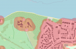
I've managed to create a map containing 50m distances to buildings in my local area, as well as highlighting local airports and runways. It doesn't include things like no fly zones etc (which you would always want to verify on the fly), but has the added benefit of being importable as an offline map on my Android phone so no matter where I am I at least know the location of nearby buildings and airports (and potentially other features).

Is this something that you might find useful? Its not a straightforward process but it should be easy to follow a tutorial written specifically for ths use case. Let me know and if theres a benefit I'll bung a step-by-step guide together.
Cheers!
Dan
I've managed to create a map containing 50m distances to buildings in my local area, as well as highlighting local airports and runways. It doesn't include things like no fly zones etc (which you would always want to verify on the fly), but has the added benefit of being importable as an offline map on my Android phone so no matter where I am I at least know the location of nearby buildings and airports (and potentially other features).

Is this something that you might find useful? Its not a straightforward process but it should be easy to follow a tutorial written specifically for ths use case. Let me know and if theres a benefit I'll bung a step-by-step guide together.
Cheers!
Dan


