DJI Mavic, Air and Mini Drones
Friendly, Helpful & Knowledgeable Community
Join Us Now

Best time of day for strongest GPS Signals?

Rchawks

Well-Known Member
Joined
Aug 11, 2019
Messages
1,809
Reactions
2,119
Age
64
Location
Saint Joseph Mo
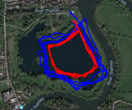
Is there such a thing? Or are there so many variables involved that time of day is regulated down the list.
 
interesting question. I just starting using UAV forecast for wind estimates and found sat info on same table.
 

Attachments

  • UAV forecast.png
    UAV forecast.png
    194.7 KB · Views: 32
There is no best time of day. It depends purely on the sky view and constellation geometry, which is not a regular function of time of day.
Constellation geometry, now thats fascinating. Thanks sar104
 
interesting question. I just starting using UAV forecast for wind estimates and found sat info on same table.
The UAV Forcast app is simply a reference. It’s not perfect, so it’s best to rely on your local area forcast and instinct. Just my experience. ;)
 
  • Like
Reactions: Thomas B
Solar flares can affect radio reception, including GPS. And while that is not normally an issue, it would still suggest night flying should experience less solar radiation disruption.
 
Solar flares can affect radio reception, including GPS. And while that is not normally an issue, it would still suggest night flying should experience less solar radiation disruption.

That might be consideration if solar disruption of GPS signals were actually an issue, but it almost never is.
 
  • Like
Reactions: Gindra
GPS sat's are not in Geosync' orbit @GregE ... GPS satellites fly in medium Earth orbit (MEO) at an altitude of approximately 20,200 km (12,550 miles). Each satellite circles the Earth twice a day.
 
Last edited:
There is a factor that affects the accuracy of GPS that is to do with how the satellites that are 'visible' to the GPS receiver, are spread across the sky. If you can imagine that you might have 8 sat's all within a 45-degree arc overhead, that is not going to give you as good a 3D location as 8 sat's visible across 180 degrees of sky. Same can be said if your GPS receiver is in a canyon (natural or Urban), where the visible arc of sky is reduced. These 'positional' influences are known as 'Dilution of Precision' ...

 
  • Like
Reactions: mereflyer and GregE
The overall spec for x y position information is a probability - the position will be within 16 feet of the “true” position 95% of the time. Generally, the results are much better, but that is the spec.
 
Some other, irrelevant information that is interesting is that there needs to be some compensation for the lower gravity and also the speed of the GPS satellite as both of these things change time itself. Without this compensation, GPS would be off by miles. That is how sensitive the system is.
 
  • Like
Reactions: FoxhallGH
Here is a link to planning your mission around the GNSS availability. Trimble GNSS Planning Tool. I recommend setting your elevation mask to 15° as anything below that can cause some discrepancies due to poor geometry and atmospheric refraction. Water and other reflective surfaces can cause degradation also. There are so many variables. I studied this extensively at the university and have used survey-grade GPS since the '90s. Another even more detailed tool is located at GNSS Mission Planning. Any spike in the DOP is not a good time to fly. you can see the correlation of high DOP to low SV availability and/or geometry. If you have any questions please feel free to ask.
 
  • Like
Reactions: GregE
That might be consideration if solar disruption of GPS signals were actually an issue, but it almost never is.
True. And, we are in the midst of Solar Minimum, an approximately 11-12 year period of decreased solar activity. We haven't had flares or coronal mass ejections for some time. Not even sunspots.

The Kp index reported on UAV forecast and other places, is a rating of the geomagnetic disturbance created by solar winds, flares and CMEs. The higher the rating, the more disturbance to radio transmissions. It this radio transmission idea that can possibly affect drones.

As far as "time of day" is concerned, the ionosphere contracts and "hardens" during nighttime hours. This hardening allows HAM operators to bounce their transmission signals off the bottom of the ionosphere and reach receivers way beyond the daytime limits imposed by the earths curvature. This has nothing to do with GPS of course, just an interesting aside (to geeks like me!).
 
The GPS satellites move around the earth as stated, so sometimes they are lower on the horizon than other times, this is what can affect a signal somewhat. With that said, there are 24 satellites up there that are operational with about another four or five just hanging out in the various tracks, ready to be switched on in case one of the active ones drops a signal for any reason. This way they always have 24 running at any given time, for best accuracy. Now there may be times when the military will shut off the signal for civilian use, due to some threat or what ever, but that is so rare that you really don't need to be concerned about that happening. You can track satellites to see just where they are positioned in the sky at any given time.
 
  • Like
Reactions: Gindra
What isn't so rare, especially in states like Nevada, is intentional blocking of GPS signals by the military testing their jamming equipment. The FAA sends Notams to pilots ahead of the planned GPS outages. This may be unlikely to affect most terrestrial GPS use, as the affected area is like an inverted cone, with distance (radius) increasing dramatically with altitude up into the flight levels. It is a pain in the hind end for small aircraft trying to use GPS to circumnavigate the often complex restricted airspace when the only ground features are lots of mountains and valleys that look similar - (NV is the most mountainous state in the lower 48).
 
Lycus Tech Mavic Air 3 Case

DJI Drone Deals

New Threads

Forum statistics

Threads
131,122
Messages
1,560,053
Members
160,097
Latest member
sedmonds