A couple of things.
If you're outside of the airspace, but still in a UASFM gird, you don't need permission to fly. As mentioned, it is a round peg, square hole situation. The only time you need to worry is if you are in the actual airspace. Any time airspace touches a square, that entire square shows an AGL limit, but it only applies to the area inside the airspace in that gird.
The ultimate authority on the airspace is the FAA, not AirMap, not Skyward, and not DJI.
Put your address in the search box at the FAA's ArcGIS site (
ArcGIS Web Application). That is the ultimate authority. Make sure you have all of the boxes below checked. You also need to check for NOTAMs and TFRs. Use
www.1800wxbrief.com for that.
If you are in an area that you are allowed to fly in, and the DJI App won't let you take off, go to
www.dji.com/flysafe and apply for a custom unlock. Once you have that, you can turn it on and off and fly at your house.
As far as why the grids are used instead of the actual airspace is for uniformity between airports. Each grid represents 1 minute of latitude by 1 minute of longitude. That system works pretty well, but not great. There is talk of reworking the grids to be 1/2 minute square. That should make things a little better.
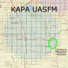
And the reason they don't use concentric circles is because the AGL is determined by flight paths, not distance from the airport. If the FAA used concentric circles, the AGL would either be too small for safety, or too large practical use. And in some UASFMs we have random 0AGL grids due to hospital helipads. See the KAPA UASFM below.


")


