You are using an out of date browser. It may not display this or other websites correctly.
You should upgrade or use an alternative browser.
You should upgrade or use an alternative browser.
Can someone clarify....
- Thread starter GrayFlame
- Start date
- Joined
- May 27, 2017
- Messages
- 14,458
- Reactions
- 19,469
- Location
- Los Alamos, NM
- Site
- www.mavicpilots.com
YesOk. So i can fly in areas like this as long as i basically use common sense and watch for manned aircraft?
So when exactly are you required to "Get approval" through LAANC or FAA drone zone? Will there be a message saying i need to get approval before flight? Im sorry if i sound dumb in this topic but im only a couple months into it and i want to make sure im not breaking any laws or rules per say. I dont want to be "that guy". Thanks guys look forward to learning more!!
- Joined
- May 27, 2017
- Messages
- 14,458
- Reactions
- 19,469
- Location
- Los Alamos, NM
- Site
- www.mavicpilots.com
LAANC approval is needed to fly in surface controlled airspace (B, C, D or E). It doesn't apply to special use airspace, where it is either already legal to fly (such as Alert areas) or completely forbidden (e.g. Prohibited areas).So when exactly are you required to "Get approval" through LAANC or FAA drone zone? Will there be a message saying i need to get approval before flight? Im sorry if i sound dumb in this topic but im only a couple months into it and i want to make sure im not breaking any laws or rules per say. I dont want to be "that guy". Thanks guys look forward to learning more!!
Man i really appreciate all this info! Thank you very much. This has eased my nerves so that i can now enjoy flying in my area and not work about breaking and laws. Where exactly can i bring up a map of all the different airspace like you mentioned.........B,C, D and so forth?LAANC approval is needed to fly in surface controlled airspace (B, C, D or E). It doesn't apply to special use airspace, where it is either already legal to fly (such as Alert areas) or completely forbidden (e.g. Prohibited areas).
Rich QR
Well-Known Member
I think the best source is to get a VFR sectional chart that covers your area. You can download them digitally from here: VFR Raster Charts You can also get printed paper sectional charts from Sporty's Pilot Shop, or if there's a nearby airport with a flight school, they'll have them there (and they shouldn't mind selling them to non-students).Man i really appreciate all this info! Thank you very much. This has eased my nerves so that i can now enjoy flying in my area and not work about breaking and laws. Where exactly can i bring up a map of all the different airspace like you mentioned.........B,C, D and so forth?
The downloaded sectionals are free. The paper sectionals cost about $9.00. Either way, new ones come out every couple of months, usually only with minor updates, but occasionally with updates that will affect you.
Read the legend of the sectional carefully, especially the box labelled "AIRPORT TRAFFIC SERVICE AND AIRSPACE INFORMATION". There's a lot of information on the charts, and it's not trivial to figure out what it all means, but it's not as complicated as it first seems. This is a fair bit of what's covered in a Part 107 license study course. If you're motivated to take such a course, do so, whether or not you intend to get your license and fly commercially. If you're not ready to take a full course, you can at least browse the free FAA study guide at https://www.faa.gov/regulations_pol...s/aviation/media/remote_pilot_study_guide.pdf It contains all the info on airspace types, and how to read sectional charts. Some of the paid courses may do a better job of presenting it in an easily digestible format, though.
If you have specific questions about the airspace of a particular area, try to find it on a sectional chart, and if needed, post a question here, describing nearby airports and landmarks so that we can find the same spot, and someone will be able to clarify what the map means.
- Joined
- May 27, 2017
- Messages
- 14,458
- Reactions
- 19,469
- Location
- Los Alamos, NM
- Site
- www.mavicpilots.com
Man i really appreciate all this info! Thank you very much. This has eased my nerves so that i can now enjoy flying in my area and not work about breaking and laws. Where exactly can i bring up a map of all the different airspace like you mentioned.........B,C, D and so forth?
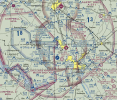
Or use a free website like SkyVector. The screenshot below shows that your location just NW of Cunningham is inside A-371 but in Class G airspace.

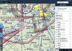
Not quite as easy as using ForeFlight (below), in which you can have it list the airspace properties, but certainly cheaper.

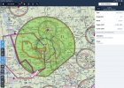
I like AirMap Web App which is better suited to sUAS than aeronautical charts. Scroll, zoom, and readily see the advisories, etc.
Similar threads
- Replies
- 53
- Views
- 2K
- Replies
- 3
- Views
- 802
- Replies
- 27
- Views
- 3K
DJI Drone Deals
1. Mini 2
2. Mini 3 Pro
3. Mini 4 Pro
4. Air 2s
5. Air 3
6. Avata 2
7. Mavic 3 Pro
8. Mavic 3 Classic
2. Mini 3 Pro
3. Mini 4 Pro
4. Air 2s
5. Air 3
6. Avata 2
7. Mavic 3 Pro
8. Mavic 3 Classic


![B46153BC-7A21-46D7-84B3-27705769FFC7[218].JPEG B46153BC-7A21-46D7-84B3-27705769FFC7[218].JPEG](https://mavicpilots.com/data/attachments/129/129052-d9feaa2942798f2c5055da4e777340b8.jpg)


