

My mistake with wording. By no-fly zone, I mean flight restriction.Buy the App called "Drone Pilot"
It has all the provincial parks shaded in blue. When you click on the park it will give you a message stating authorization is needed from the park superintendent. I have never had a problem getting permission when I did my video of how the parks changed through the seasons. Your asking Transport Canada to make them NFZ's when they are not. Don't ask for something that clearly will not be of benefit if that ever happens. Its not hard to figure out where provincial parks are.
View attachment 132800
Drone Pilot Canada
dronepilotcanada.com
You are using an out of date browser. It may not display this or other websites correctly.
You should upgrade or use an alternative browser.
You should upgrade or use an alternative browser.
Canada No-fly zones map https://nrc.canada.ca/en/drone-tool/
- Thread starter Kajtek
- Start date

It is not easy to find all areas with flight restrictions. And in my previous post, I explained that I made mistake call them no-fly zones. This app that you recommend is pricy but I would buy it without hesitation if it really is as good as you sayBuy the App called "Drone Pilot"
It has all the provincial parks shaded in blue. When you click on the park it will give you a message stating authorization is needed from the park superintendent. I have never had a problem getting permission when I did my video of how the parks changed through the seasons. Your asking Transport Canada to make them NFZ's when they are not. Don't ask for something that clearly will not be of benefit if that ever happens. Its not hard to figure out where provincial parks are.
View attachment 132800
Drone Pilot Canada
Could you post a screenshot of this area that is on my screenshot? There are two areas where drones are not allowed. If they are present on the map of the app then I will buy this app.
Attachments
Jagerbomb52
Well-Known Member
Nope neither one is marked on the map. Just says historical site. I suspect historical sites that don't have any Provincial or National Park status would be the same as Conservation Areas. They do not allow drones either but are not NFZ. Where I live the Conservation Areas are looked after by the Provincial Park maintenance crew. So if I would need to fly those areas I guess the park superintendent would be the guys to ask. Not sure as I have never researched this.It is not easy to find all areas with flight restrictions. And in my previous post, I explained that I made mistake call them no-fly zones. This app that you recommend is pricy but I would buy it without hesitation if it really is as good as you say
Could you post a screenshot of this area that is on my screenshot? There are two areas where drones are not allowed. If they are present on the map of the app then I will buy this app.
Last edited:
MrHawkeye
Member
Here I was about to wade in and be all lol not all provinces folks but reading into it I'm actually not aware of any province aside from Manitoba that hasn't taken a position against drones in provincial parks. Learned something today.
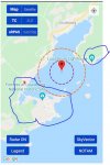
Here's a screenshot from the latest v2.7 of Drone Pilot Canada.Nope neither one is marked on the map. Just says historical site.
The circles are just 500m and 1km radius references from any point you click on the map.

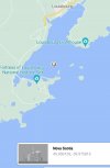
Thank you. This is the problem that I have. On this map, there is a provincial park where the Louisbourg Lighthouse is and there is a Historic Site where the Fortress is. I was flying my drone 1km out of the gate to the fortress on the route that is going through the Louisbourg city and passes the Fortress Peninsula. On my picture, I marked approximate (what I think) boundaries and the red spot where I was flying my drone thinking that I am out of the Fortress boundaries. Ranger stopped and told me that I was on the property of the Historic site and drones were not allowed. He was nice, I landed my drome but I was embarrassed. This is why I would like to have a map that clearly shows the boundaries of provincial parks and Historic sites where drones are not allowedHere's a screenshot from the latest v2.7 of Drone Pilot Canada.
The circles are just 500m and 1km radius references from any point you click on the map.
View attachment 132870
Attachments
I once considered flying my Phantom at Scarborough Bluffs park on Lake Ontario, just East of Toronto. But, I kid you not, there was a sign in the park prohibiting the flying of kites! Huh?I'm actually not aware of any province aside from Manitoba that hasn't taken a position against drones in provincial parks.
The park is 15km East of the Toronto Island Airport. There are aircraft flying low along the lakeshore on approach to that airport, staying below the greater control zone of Toronto International Airport. Is that maybe why kites aren't allowed there? Who knows?
Back then there weren't any signs explicitly prohibiting drones, but there were too many people around so I decided against flying there. It's been done many times by others since then. Search YouTube for "scarborough bluffs drone".

Jagerbomb52
Well-Known Member
Well I tried looking for the Provincial Park at the Lighthouse and close by but have found none. Are you sure it is listed as a Provincial Park? Anything I have found says Historical Site. Lots about the trails around there. They would still not allow drones since its a historical site. Have you got a name for this Provincial Park?
I'll send an email to Don, with a link to this topic thread, to see what he says.I would like to have a map that clearly shows the boundaries of provincial parks and Historic sites where drones are not allowed
His app is constantly being updated. I'm sure he appreciates any feedback.
Jagerbomb52
Well-Known Member
I can't say for sure but I did find one map that shows a black outline of where the fort is. That could be the boundary's of the historical site on that side. I found nothing where the light house is so the boundary's could be anywhere. There must be records someplace but probably would have to be local to find them.

dondroneson
Member
Interesting discussion! Sorry I'm late to the party, but thank you zbip for inviting me! Firstly, yes Drone Pilot Canada shows the boundaries of both National and Provincial Parks, and a quick summary of their drone policies...which vary by province. The Fortress of Louisbourg is a National Historic Site, but neither a national nor provincial park. That said, there are a ZILLION places that have defined their own rules for activities ON their property, and this place may well have declared those. But other than National Parks, none of these places have any jurisdiction over their airspace, so yes you can fly OVER them. Note that the right to fly over them does NOT give you the right to harass people or wildlife, nor to infringe on privacy.
Drone Pilot Canada is updated regularly with new features, and the aerodrome/airspace data is refreshed every 56 days, following the CFS/DAH data updates. All features are documented in a simple user guide available on www.DronePilotCanada.com, and there are tutorials showing everything from simply getting started to very detailed feature walkthroughs here: https://youtube.com/playlist?list=PLOooCCedWECU9jYxkHyaqtvCkrAyhYpB1 Drone Pilot Canada is available on both iOS and Android, and has data synchronization capabilities between the platforms.
And to our American friends, while the SFOC process is technically the way to get permission to fly a drone over 250g in Canada, at present, Transport Canada is not accepting applications for recreational flying....
Arkhira
Active Member
Interesting discussion! Sorry I'm late to the party, but thank you zbip for inviting me! Firstly, yes Drone Pilot Canada shows the boundaries of both National and Provincial Parks, and a quick summary of their drone policies...which vary by province. The Fortress of Louisbourg is a National Historic Site, but neither a national nor provincial park. That said, there are a ZILLION places that have defined their own rules for activities ON their property, and this place may well have declared those. But other than National Parks, none of these places have any jurisdiction over their airspace, so yes you can fly OVER them. Note that the right to fly over them does NOT give you the right to harass people or wildlife, nor to infringe on privacy.
Drone Pilot Canada is updated regularly with new features, and the aerodrome/airspace data is refreshed every 56 days, following the CFS/DAH data updates. All features are documented in a simple user guide available on www.DronePilotCanada.com, and there are tutorials showing everything from simply getting started to very detailed feature walkthroughs here: https://youtube.com/playlist?list=PLOooCCedWECU9jYxkHyaqtvCkrAyhYpB1 Drone Pilot Canada is available on both iOS and Android, and has data synchronization capabilities between the platforms.
And to our American friends, while the SFOC process is technically the way to get permission to fly a drone over 250g in Canada, at present, Transport Canada is not accepting applications for recreational flying....
Hi Don,
I discovered your channel less than a week ago and watched through most of videos a few times. Got my Mini 2 and passed the basic cert in under a week. I have been eyeing your app for when I am in areas not well known or more complex such as Nova Scotia. How does the roadmap look for it? I assume there is no end in sight? It is a shame that the Nav Canada app lacks a lot of information.
Just thought I would chime in Nav Canada is pretty iffy, shows the prison no fly, Abbotsford airport no fly, nothing about the floatplane operation. And they are low very low, they take off mostly to the east. It is not a huge operation but it is still there. There are no local bans which is nice.

dondroneson
Member
Wow, Arkhira! If you've watched most of my videos, your eyes must hurt!! LOL. We have complete coverage of Nova Scotia from both a national park and provincial park perspective. We worked directly with the park people to ensure we were accurately portraying the various flavours (eg wilderness conservation areas) and the associated policies. It IS pretty complex in NS!! Drone Pilot Canada continues to evolve both from a feature and data perspective. You might be interested in watching the recent "Meet the Developer" video:Hi Don,
I discovered your channel less than a week ago and watched through most of videos a few times. Got my Mini 2 and passed the basic cert in under a week. I have been eyeing your app for when I am in areas not well known or more complex such as Nova Scotia. How does the roadmap look for it? I assume there is no end in sight? It is a shame that the Nav Canada app lacks a lot of information.
dondroneson
Member
The float plan dock also does not show on Drone Pilot Canada (no surprise...we base our map on exactly the same data!). This merely means it is neither registered nor certified. That is totally normal and one of the hazards of flying near water in Canada...float planes don't need an airport to land or take off. This is why the 'keep out of the way of manned aircraft" rule exists. BTW, I don't see the NOTAM for the Abbotsford Airshow showing on the above map, but it may have gone up just after you did your screenshot. Drone Pilot Canada is showing this (and it even shows as a DJI unlock requirement...can't say that I've seen one of these temporary DJI authorization zones before! (Drone Pilot Canada shows DJI zones...).Just thought I would chime in Nav Canada is pretty iffy, shows the prison no fly, Abbotsford airport no fly, nothing about the floatplane operation. And they are low very low, they take off mostly to the east. It is not a huge operation but it is still there. There are no local bans which is nice.
View attachment 132876
@dondroneson seeing we are on the subject, does your product operate offline ? Download to device prior to trip and work without cell or Wi-fi. Cell is pretty spotty in a lot BC and having an off line reference would be handy.
Location can be picked up via GPS, so that part is "simple" for me.
Location can be picked up via GPS, so that part is "simple" for me.
dondroneson
Member
Yes it does operate "off line" (ie, without internet access). There are some limitations; here is the page from the Users Guide (which is available for free from www.DronePilotCanada.com):@dondroneson seeing we are on the subject, does your product operate offline ? Download to device prior to trip and work without cell or Wi-fi. Cell is pretty spotty in a lot BC and having an off line reference would be handy.
Location can be picked up via GPS, so that part is "simple" for me.

Robert Prior
Well-Known Member
I disagree with you here. What we have works well, and it's not like you can easily get into a provincial park and not realize it — most parks (other than Alberta, IIRC) have entrance gates and require payment.I encourage all Canadian users to e-mail [email protected] and cc to [email protected] and request that they mark all no-fly zones on their map at Drone site selection tool - National Research Council Canada Now they have also a mobile app. . Right now there are a lot of no-fly zones that are not marked, like Provincial Parks for example. It would be useful for planning to have a map with all no-fly zones. I wrote to them and asked them to add all no-fly zones and their answer was that I could contact provincial parks for permission, which was not my request or question. Maybe if there will be many requests, they will do it. With so many restrictions and their expectation that we follow the rules we deserve a good map with no-fly zones.
What about municipal parks? Conservation areas? There are lots of smaller authorities that have banned drones. But like Agustine said upthread, what they have banned is operating a drone from their land, not flying a drone over it, because they don't have that authority.
Robert Prior
Well-Known Member
Yes, it does. I rely on that feature while on the road a lot, because my old iPhone 4 often doesn't get much bandwidth for data!@dondroneson seeing we are on the subject, does your product operate offline ? Download to device prior to trip and work without cell or Wi-fi. Cell is pretty spotty in a lot BC and having an off line reference would be handy.
Location can be picked up via GPS, so that part is "simple" for me.
Even if you don't have a map displaying* it still displays your location and any nearby flight zones like airports and heliports. Very useful for ensuring that you're not near an airport you didn't know about.
My usual practice when on a road trip is to scroll to the area I plan on flying while I'm at home with Wifi, so that when I arrive the map is loaded for me.
*Because you flew across the country and stupidly forgot to connect to Wifi after you arrived).
Robert Prior
Well-Known Member
There was a park in Toronto that started to be used for kite-fighting competitions. Strong string, often with added glass to cut other kite strings, and people were getting cut on abandoned string left behind by the competitors (not to mention the risks of low-flying fighting kites slicing someone).I kid you not, there was a sign in the park prohibiting the flying of kites! Huh?
Don't know if the Bluffs is where that happened or not. It was a couple of decades ago and I wasn't paying much attention.
I've flown off the Bluffs a few times. Didn't see any signs prohibiting drones (and I checked). I walk down to the lake, though, and fly from there over the water, not off the top of the Bluffs, so we may be talking about different parks.
Similar threads
- Replies
- 0
- Views
- 548
- Replies
- 15
- Views
- 5K
- Replies
- 0
- Views
- 2K


DJI Drone Deals
New Threads
-
DJI RC PLUS - MODS FIRMWARE TO BE ABLE TO RUN WITH MAVIC PRO 3, AIR 2S
- Started by pmcworldwide
- Replies: 2
-
-
 Air 3 Newbys & Flat Rock Lookouts - NSW Australia 🇦🇺
- Started by Squidinc
- Replies: 1
-
-
Forum statistics
