

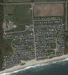
Hello everyone. Checking in from southern Rhode Island. I'm not new to drones, but am new to the Mavic 3 & RC Pro. I finally upgraded from my Phantom 1 Pro as she was a dinosaur. Wished I waited a bit longer as I would have bought the Pro version, oh well. I mostly use it for recreational photography, but I would also like to utilize it for my business. I was hoping it could be used for mapping our 50+ acre property. Both to visually document 1500ft of beach erosion, and to possibly keep track of the 377 seasonal cottages and alterations and changes made to them. Any information or advice regarding these two areas of concern would be greatly appreciated. TIA

Checking In From Rhode Island
- Thread starter TBird78
- Start date


")


")

Similar threads


DJI Drone Deals
New Threads
-
 Mini 3 Creag Riabhach Wind Farm, Altnaharra, Sutherland
- Started by AlbionDrones
- Replies: 0
-
-
-
-
Forum statistics
