I was just flying behind my house - a place I fly often. I suddenly got an alarm and saw the message “Warning Area. Fly with caution” - or something like that. I decided to come home. I went to the bottom left of the screen and enlarged the map that shows location of drone & controller (There we’re trees blocking my view) I started to follow the line back & the drone was very slowly responsive -if at all. I realize now I should have either hit RTH or just gone up but I thought I was flying above the trees. Anyhow, I slowly followed the line & then heard a crash in the trees and screen said signal lost. I used “find my drone” and found it at the base of a tree with one of the front foot antennae partially cracked. (Glad I have coverage) I went into profile in DJI FLY and can see my track, but: 1) How do I find out more information to try to understand what went wrong? And, 2) How do I share all of that here to get help from all of you? Thank you all in advance. Now I have to figure out how to file a claim with DJI.
You are using an out of date browser. It may not display this or other websites correctly.
You should upgrade or use an alternative browser.
You should upgrade or use an alternative browser.
Cray help needed
- Thread starter marshvet
- Start date
For the best help to find out what exactly happened, go to the Mavic Crash and Fly Away Assistance Topic HERE
Once there check out the Top "Sticky Thread" - it will show you how to retrieve the log data. Then post a new thread there about what happened, there are experts here that will be able to tell you exactly what went wrong. Good Luck.

Once there check out the Top "Sticky Thread" - it will show you how to retrieve the log data. Then post a new thread there about what happened, there are experts here that will be able to tell you exactly what went wrong. Good Luck.

Oman
Well-Known Member
Go to DJI Flight Log Viewer | Phantom Help1) How do I find out more information to try to understand what went wrong? And, 2) How do I share all of that here to get help from all of you?
Follow the instructions there to upload your flight record from your phone or tablet.
That will give you a detailed report on the flight data.
Come back and post a link to the report it provides.
Or just post the text file
It was set at 301' but I was not smart enough to try it. Hindsight is 20:20!What was your RTH height set at?
I went there and tried to follow but I have the RC Pro and the screen they say should show up when I "swipe down" did not appear.Go to DJI Flight Log Viewer | Phantom Help
Follow the instructions there to upload your flight record from your phone or tablet.
That will give you a detailed report on the flight data.
Come back and post a link to the report it provides.
Or just post the text file
I finally figured out that if I go in to the RC Pro and follow: Files, Internal Storage, Android, Data, DJIgov5, Files, Flight record - I get a listing of the flight records by date. If I select the one in question, it tries to open it and the arrow just keeps on circling. If I select it and hit the button that shows how to share, it will not share via Bluetooth. So, then I select Firefox to email it but I cannot figure out how to include it in the email. Any help is appreciated. Thanks!!
I was able to connect my RC PRO to my computer and do as above. But when I try to open it, it is gibbertish. I will try to share it here and see if any of you can meake heads or tails of it.I finally figured out that if I go in to the RC Pro and follow: Files, Internal Storage, Android, Data, DJIgov5, Files, Flight record - I get a listing of the flight records by date. If I select the one in question, it tries to open it and the arrow just keeps on circling. If I select it and hit the button that shows how to share, it will not share via Bluetooth. So, then I select Firefox to email it but I cannot figure out how to include it in the email. Any help is appreciated. Thanks!!
Attachments
I was just flying behind my house - a place I fly often. I suddenly got an alarm and saw the message “Warning Area. Fly with caution” - or something like that. I decided to come home. I went to the bottom left of the screen and enlarged the map that shows location of drone & controller (There we’re trees blocking my view) I started to follow the line back & the drone was very slowly responsive -if at all. I realize now I should have either hit RTH or just gone up but I thought I was flying above the trees. Anyhow, I slowly followed the line & then heard a crash in the trees and screen said signal lost. I used “find my drone” and found it at the base of a tree with one of the front foot antennae partially cracked. (Glad I have coverage) I went into profile in DJI FLY and can see my track, but: 1) How do I find out more information to try to understand what went wrong? And, 2) How do I share all of that here to get help from all of you? Thank you all in advance. Now I have to figure out how to file a claim with DJI.
Did you notice that altitude displayed on the flight back? Was the video feed to your phone/tablet screen not working?
I did not notice the altitude at the time. The video feed was there. I was getting the incessant beeping and the warning and since I could not see the drone through the trees, I immediately went to that map in the lower left corner to follow the flight back to me. At that point, though, as I tried to follow it, the drone seemed very unresponsive to commands. Instead of being smart and just going up or hitting RTH, I continued to try to follow that path and then crash.Did you notice that altitude displayed on the flight back? Was the video feed to your phone/tablet screen not working?
Another option to RTH is to climb. Usually, the signal between the drone and controller is be better at greater altitude. Greater altitude will also keep you out of the trees on the way home. Monitoring the video feed with the camera tilted down 45 degrees or so is good for seeing obstacles ahead and below. I find that it's helpful to have the map view open but not filling the screen, so that I can still see the video feed.I did not notice the altitude at the time. The video feed was there. I was getting the incessant beeping and the warning and since I could not see the drone through the trees, I immediately went to that map in the lower left corner to follow the flight back to me. At that point, though, as I tried to follow it, the drone seemed very unresponsive to commands. Instead of being smart and just going up or hitting RTH, I continued to try to follow that path and then crash.
The unresponsive performance you described is another matter. I suspect you'll be hearing from the forum members who are so helpful and generous with their time in analyzing problems.
- Joined
- May 25, 2017
- Messages
- 8,476
- Reactions
- 7,966
- Age
- 63
Will be an interesting analysis, in case missed above the txt is in post #9.
The gibberish is decipherable in phantomhelp or airdata.
I’m away and on phone, so difficult to save, upload etc.
The warning alone might not be known, some sort of temporary NFZ ?
Unresponsive ? Maybe OA wouldn’t allow you to move into trees ?
RTH would have gone to safe altitude if set correctly, or increased altitude to avoid them if too low (not foolproof in fine branches).
Here's a link to the PhantomHelp site using your uploaded txt log file.I was able to connect my RC PRO to my computer and do as above. But when I try to open it, it is gibberish. I will try to share it here and see if any of you can make heads or tails of it.
www.phantomhelp.com/LogViewer/21BK890LHV5JT6N0QZVL
Basically, you lowered the altitude of your drone and backed it into the trees. It's a prime example of why it's important to keep the drone within visual line of sight. Why didn't you just walk out into the field and fly from there, rather than flying from your driveway with all those trees in the way?
Also, you really should take some time to familiarize yourself with DJI's Geo Zone system, what it means, and how it affects where you can/can't fly your drone. See: www.dji.com/flysafe/geo-map
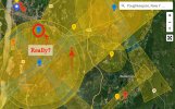
Your location lies within a Warning Zone,
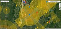
Last edited:
That's a RC hobby flying site. Just happens to be located on a church's property.Really?
I was curious what that other blue marker is, just North of the Poughkeepsie Airport.
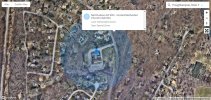
View attachment 148607
It's a church! Really? Eh? You actually need to get authorization these days to fly over a church?!? How crazy is that?
View attachment 148608
On their website, under Directions, they list two flying fields. One is the Red Wing Field, located here:That's a RC hobby flying site. Just happens to be located on a church's property.
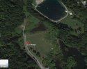
The other is Wallkill Field, conveniently(?) located directly adjacent to a prison, here:
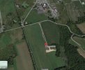
The church is listed as their "Location of regular meetings." But if you read any of their recent meeting minutes, it seems they rarely ever meet at the church.

The church doesn't look like a suitable flying field, at least not when compared to the other two fields. Neither of the two model flying fields are marked as Authorization Zones on DJI's Geo zone map, but the prison certainly is a red Restricted Zone.
Why would/should any church be marked as an Authorization Zone? It's bizarre.
Similar threads
DJI Drone Deals
New Threads
-
-
-
Last Week's Most Popular Topics (January 10, 2026)
- Started by msinger
- Replies: 0
-
Mavic 4 bought in Japan, currently in US, and needs warranty repair. What are my options?
- Started by Theoriginalgregtoo
- Replies: 9
-


