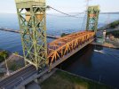
Yes, the bridge is the Burlington Canal Lift Bridge, a Government of Canada operated bridge that connects the cities of Burlington and Hamilton across the Burlington Canal, on the western tip of Lake Ontario, in Ontario, Canada.
A bridge has existed here since 1830. The current bridge was built in 1962. It only operates during the shipping season (which means it is closed during winter), and allows bulk transports into Hamilton to deliver materials for the several steel producers located there. It also raises to allow sailboat and other larger motor vessels in and out of the bay.
The canalside (including the two piers) on the east side is under the regulatory authority of the Hamilton Conservation Authority. The west side is the Halton Conservation Authority, and there is a large federal government building housing a Coast Guard establishment and Environment Canada offices. The federal government does not prohibit drone use from its parking lot, but both conservation authorities do. The airspace is Class G, but within a water aerodrome, so pilots are cautioned to keep watch for occasional seaplane traffic (I have never seen one land or take off).
I could probably fly from the Government of Canada building parking lot, which would give me a wider angle shot of the bridge, it would be framed by the taller Burlington Skyway (a double-span highway bridge about 80 m away from the lift bridge over which the QEW highway travels). The other option is from a vessel, but if I launched from the piers I would technically be trespassing on the conservation authority property, since neither one allows drone us without permission and payment of photography fees.


