You are using an out of date browser. It may not display this or other websites correctly.
You should upgrade or use an alternative browser.
You should upgrade or use an alternative browser.
From Canberra,Australia
- Thread starter Sime
- Start date
Glenh
Well-Known Member
Sime, not my problem but if you are flying 4km then you are flying Beyond Visual Line of Sight (Contrary to CASA regulations). Also, you seem to be flying over a highly restricted area. Not my problem but are you aware that you are breaking Aeronautical laws? Just saying.Yes, it’s 4km from my house
PakNheat380
Well-Known Member
twickers14
Well-Known Member
A warm welcome from the UK. Cold and windy here with. Dose of rain too. Perfect flying conditions NOT! Hope you enjoying your summer.
Suzygs1000
Well-Known Member
Putting up posts like this will earn you the ire of some of us ...I love flying 2.5 Km’s away and taking closeups of these metal frames on top of hills. There’s something cool about have such control over something far away, I wish these were around when I was a kid.
I’m sure I’ll sleep at night. But thanks for pointing it out.Putting up posts like this will earn you the ire of some of us ...
But please explain your issue, flying my drone in an area completely devoid of any population ………………
Last edited:
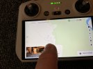
See the location I’m pointing at, and the lack of the dji map mentioning any restrictions in that area, that’s exactly where that tracking station is at. It’s not a restricted flying zone.Also, you seem to be flying over a highly restricted area
Attachments
- Joined
- Oct 12, 2016
- Messages
- 30,371
- Reactions
- 34,325
- Location
- Harrisburg, PA (US)
- Site
- mavichelp.com
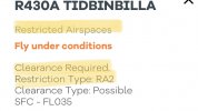
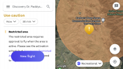
Actually yes I do. The site is permanently active 24x7. As one of NASA’s Deep Space Network it is one of the three active earth stations transmitting and receiving to all NASA’s spacecraft within and external to the solar system including orbiting and surface explorers and the International Space Station.Try instead and use a proper map that clearly shows you are flying in Restricted Airspace.
View attachment 159546
The maps you are required to use, and approved by CASA, clearly show this is a restricted area.

- Joined
- May 25, 2017
- Messages
- 8,476
- Reactions
- 7,966
- Age
- 63
..
Hmm, well this is a good place for drone pilots to learn from others.
There are numerous tools (maps and NOTAM type services) that can often vary between them for restrictions.
In general, the CASA approved apps are the best for more rec pilots to use, and the occasional check of the DJI Flysafe Geo Map is good to check if flying somewhere requiring some distance to travel, so you don't get surprised with an unexpected NFZ.
CASA also covers the general rules to fly, including VLOS, the OP has been flying for a lot of years, and would expect he'd know these (?).
But as many here will admit, flying BVLOS is not always strictly adhered to, but should be where any chance of manned aircraft is possible.
I know the areas where the OP is flying for the trig point pics, have walked in there through Namadgi area and while it is remote, it's close enough for choppers, park and other such ops etc to be going on at any time, and flying too far away you simply lose any chance of situational awareness to know and avoid.
I'm not going to lecture anyone here, but perhaps touching on this can bring about a learning process that leads to safer flights.
A helicopter was flaying in that exact area today, probably lower than I fly around there. It happens, but it’s rare. There’s never ever and other aircraft. Not making excuses, but you can hear them coming a mile away. If it happens to be while I’m flying even on the opposite side of the mountain that the station is on, as soon as I was to hear a chopper, I’d drop the drone to as low as I can instantly, I would make zero attempts to fly it back.
And this will be an attempt to explain my ignorance here, I was always under the assumption the the DJI maps told you where you can and can’t fly, for example, the airport and the parliamentary triangle has a very clear no go zone, so I’m assuming the drone won’t even approach the area if forced, I don’t know?
And sure, I’ve flown a lot, but I’m not a hobbyist per say, I don’t delve into the nitty gritty of it all, maps etc, I simply know that there’s restrictEd areas, like mention above, and rules of engagement in regards to flying over private property , crowds etc. so please don’t mistake me for an expert.
the picture I posted in this thread where I take a pic on top of the hill where those geo pole things are, is the type of flying I do, away from the suburbs and but all around the hills and the Murrumbidgee river.
‘Sure the drone is out of my site, and sure its not legal, but don’t have a crack at me before you look in the mirror.
Unfortunately not. DJI couldn’t possibly cover every restricted area around the world. What they can do is identify the major airports but it is not their responsibility. Most, if not all, countries have their own airspace regulators, with CASA being the body that regulates Australian airspace. CASA have worked with several software companies to provide accurate airspace maps that include all forms of restricted airspace including the obvious major airfields and most of the ‘uncontrolled’ airfields, sensitive government sites, prisons, military bases etc. Restrictions vary from No Flight Zones through to Fly with Caution. CASA approved apps cover these areas and clearly mark them on the maps and indicate what type of restriction applies.And this will be an attempt to explain my ignorance here, I was always under the assumption the the DJI maps told you where you can and can’t fly…
DJI do identify some, but not all, such sites and will have a Geo Zone restriction system that will prevent take-off or flight in such areas. Entering a Geo Zone can stop your drone when it enters such an area. Unfortunately there are cases where the Geo Zone restrictions are incorrect. Depending on restriction level you can request, online, to lift the restriction for a period of time.
I have never, and will never, fly BVLOS. As a pilot I understand the reason for the regulations and encourage others to do so to prevent further restrictions being applied to those that care about this hobby, pastime and profession. You only need to look at countries like France to see where this could lead.‘Sure the drone is out of my site, and sure its not legal, but don’t have a crack at me before you look in the mirror.
- Joined
- May 25, 2017
- Messages
- 8,476
- Reactions
- 7,966
- Age
- 63
DJI couldn’t possibly cover every restricted area around the world. What they can do is identify the major airports but it is not their responsibility.
Trouble is, the DJI Flysafe Geo Map doesn't just restrict flight near the major controlled airports, but more of an issue with minor uncontrolled airports in regional areas.
DJI often put NFZs around them, so you can't even spin your props, when CASA apps say all ok to fly with caution, with the usual clause 'land if you become aware of manned aircraft in the vicinity'.
For the OP, the CASA apps are here . . .
https://www.casa.gov.au/knowyourdrone/drone-safety-apps
I find OpenSky and AirMap are mostly what I check (often on the website format for ease pre trip), and OK2Fly is fine too.
There are others there I haven't bothered to check out, some are more orientated to RePL holders or for commercial work.
Back to your intro, this is a good place to learn, and mostly it will be done in a nice manner.
Sometimes people get a bit more 'emotional' in response to flights that are outside rules for whatever country is concerned, many have a keen interest in their hobby or indeed their work depends on the ease they can fly their drones within the framework GOVCO puts forward.
It’s a typical hobbyist forum mentality. Some approach people in a way that will make me listen to what you want to tell me, while others will just go for the throat. At the end of the day, I joined up to have a good read, if I get unfriendly pushback, I’ll just log off and carry on flying how I do.
The vast majority want to fly with as little restriction as possible but within the guidelines and regulations that we currently have. None of us want to see further restrictions applied but it’s likely inevitable due to the action of the reckless (I’m not referring to you in any way), the selfish and those just unaware.It’s a typical hobbyist forum mentality. Some approach people in a way that will make me listen to what you want to tell me, while others will just go for the throat. At the end of the day, I joined up to have a good read, if I get unfriendly pushback, I’ll just log off and carry on flying how I do.
As a forum I’m sure the majority of us want to offer advice to those with less experience, to make people aware of regulations for the country and regions in which they fly and encourage, for the benefit of all of us, to follow those regulations.
Like all forums there will be those who react differently and become abusive even when you are offering friendly advice. The forum has rules against this and the admins will step-in where required.
If a flight is knowingly breaking regulations it’s best to not publicise it. Just saying.
You could also just click the ignore button!
If a flight is knowingly breaking regulations it’s best to not publicise it. Just saying.
All I will say, regulations aside, in that area, apart from a random helicopter that may breeze by (once or twice yearly), there’s nothing out there, and a tiny Mavic cursing around well out of anyone’s sight, not heard nor seen, would cause any attention to anyone. Even the lads at the station would have zero clue the little bugger is flying around a few km away. Because if a Mavic was indeed a threat to the activity of the station, there’s no way that helicopters would be allowed in the area, plus on the other side of that mountain is a city blasting out everything under the sun.
Similar threads
- Replies
- 18
- Views
- 446
- Replies
- 16
- Views
- 860
- Replies
- 13
- Views
- 9K


