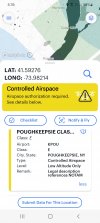
It looks like the facilities map calls all extensions E2 but as you can see from the facilities map there are no authorization boxes in the extensions indicating that no authorization is required.
Even if this airspace didn’t participate in LAANC but required authorization there would be authorization boxes which is not the case here. Furthermore, the vfr chart clearly indicates the extensions by the blue dashed line segragating the airspace. The charts are what we are suppose to go off of and the facilities map is just there for reference.
Part 107.41 reads
“No person may operate a small unmanned aircraft in Class B, Class C, or Class D airspace or within the lateral boundaries of the surface area of Class E airspace designated for an airport unless that person has prior authorization from Air Traffic Control (ATC).”
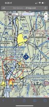
The dashed blue line indicates a segregation of the airspace, therefore, the airspace in the extensions are not “
designated for an airport” and therefore do not require authorization under part 107.
The FAA put together this very helpful slide to explain Class E airspace types and when authorization is needed.
@sar104 feel free to make any corrections or comments. We’d appreciate your input